Report on Fogo (Cabo Verde) — March 1995
Bulletin of the Global Volcanism Network, vol. 20, no. 3 (March 1995)
Managing Editor: Richard Wunderman.
Fogo (Cabo Verde) New eruption on 2 April generates lava flows within the caldera
Please cite this report as:
Global Volcanism Program, 1995. Report on Fogo (Cabo Verde) (Wunderman, R., ed.). Bulletin of the Global Volcanism Network, 20:3. Smithsonian Institution. https://doi.org/10.5479/si.GVP.BGVN199503-384010
Fogo
Cabo Verde
14.95°N, 24.35°W; summit elev. 2829 m
All times are local (unless otherwise noted)
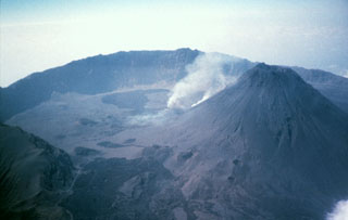
A fissure eruption that began the night of 2-3 April produced lava flows from the base of the Pico cone, located within the 8-km-diameter Cha Caldera (figure 1). This cone, also called Fogo Peak, has a crater ~500 m in diameter and 180 m deep. Caldera residents felt weak intermittent earthquakes as early as 25 March. After 0100 on 2 April the earthquakes increased in frequency, and felt events occurred at 0700 and 1500. At about 2015 residents felt a stronger earthquake that caused dishes to fall from cupboard shelves and may have opened a 200-m-long crack on the flanks of the cone.
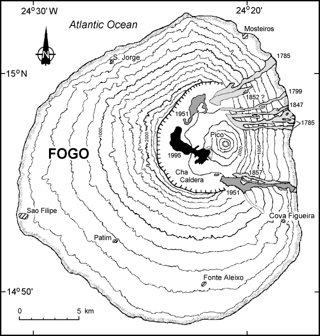 |
Figure 1. Topographic map of Fogo Island showing historical lava flows (shaded), current lava flows through 11 April (solid), and selected towns (hatched). Modified from Neumann van Padang and others (1967). |
Residents in Sao Filipe, ~15 km WSW of the vent, noticed a red glow around 2300 on the night of 2 April, probably the beginning of the eruption. Other residents reported that eruptive vents on the flank of Pico opened at 0006 on 3 April. Initially there was a burst or jetting of gas followed by ejection of large blocks. This Strombolian activity was followed by a "curtain of fire" that fed a lava flow, which cut off the main road to Portela village by 0200 (figure 2). By 0500 on 3 April, fine dark ash had begun to fall in areas close to the volcano. Around the same time, an eruption cloud to a height of 2,500 m was formed. Witnesses told reporters that the volcano was "spewing out smoke and flames." The head of the Cape Verde Red Cross stated that high flames could be seen and that "a pall of black smoke was hanging over the island."
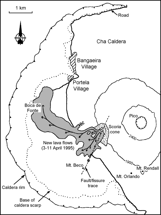 |
Figure 2. Map of Fogo caldera showing lava flows from the current eruption. Courtesy of João Gaspar, Universidade dos Açores. |
During the night of 2-3 April, several residents evacuated to the N coast. Once ashfall began, more caldera residents and some people in the eastern villages of Corvo, Achada Grande, Relva, Tintiera, Cova Matinho, Cova Figueira, and Estância Roque also evacuated to the coastal towns of Mosteiros (~9 km N of the summit) or Sao Filipe. Police officials reported that all of the ~1,300 people living within the caldera had managed to get out on foot and had been accounted for by noon on 3 April.
Under the supervision of the National Defense Minister, a Crisis Cabinet was created by the Cape Verde Government. About 60 Cape Verde Army soldiers were sent to the island and an emergency communications system was installed. Food and medicine were provided, and evacuation centers (schools, private institutions, and tent camps) were established to hold up to 5,600 people. Official reports indicated that almost 1,000 persons were sheltered in the Army camps at Sao Filipe, Patim, Achada Furna, and Mosteiros. During the first days of the eruption local authorities, Cape Verde soldiers, and volunteers, helped caldera residents save their belongings. Nobody was killed, and only 20 people needed medical assistance during the evacuation, including children with respiratory problems. Although numbers are uncertain, as many as 5,000 people may have been displaced during this eruption. As of 16 April, Portela residents continued to remove belongings by foot.
Around noon on 3 April some teachers who had driven from Sao Filipe to Mosteiros told geologist Veronica Carvalho Martins (U.S. Embassy in Cape Verde) of sandy ashfall along the road on the E side of the island just below the caldera; they also reported sounds "like an old stove." During a flight W of the caldera soon afterwards, Martins observed a high mushroom-shaped ash column rising from the caldera. Martins later saw a long fissure vent with lava fountains feeding an already well-developed flow that was moving W across a road towards the caldera wall and curving N. A vent SE of the fissure exhibited continuous strong ejection of brownish pyroclastic material, while to the NW a smaller vent was intermittently ejecting similar material.
João Gaspar (Universidade dos Açores) and colleagues from Cape Verde (ISE and IICT) reported that on 3 April a thick cloud of dark ash and vapor 2,500-5,000 m high could be seen from Santiago Island, ~60 km ENE. Early that morning three small vents were observed inside the caldera along the SW part of a N30°E fissure that crossed the main road within the caldera (figure 2). Fine dark ash and small pahoehoe lavas were produced, and large plastic bombs (1-4 m in diameter) were projected distances of 500 m. That afternoon the fissure reached 2 km in length, and four new vents opened in its NE section. Activity increased during the night of 3-4 April with the emission of more lava flows, but decreased the following morning. One Cape Verde official said that the lava was moving at a speed of 60 m/hour. Gaspar reported that explosive activity was centered at the NE vents, but strong fumarolic activity continued along the main fissure. Lava fountains reached ~ 400 m high and a cloud of dark ash and gases rose 2,000 m. A scoria cone with a crater open to the SW formed and produced aa lava flows with thicknesses of 3-10 m measured at different fronts.
Effusive activity remained intense on 4 April, but ejection of pyroclastic fragments had decreased significantly. Television pictures showed a lava "stream" coming from the fissure and, in the morning, a mantle of aa lava covering the central part of the caldera. Portuguese television and other press coverage on the evening of 5 April indicated that activity had decreased.
In the following days the lava flow reached the settlement of Boca de Fonte near the caldera wall ~2 km W of the eruption center, and by 9 April it had destroyed at least 5 houses (possibly 10), the main water reservoir, and several square kilometers of fertile land used to grow coffee, wine grapes, fruits, maize, tapioca, and beans. Reluctant farmers with cattle in the caldera were ordered to leave their homes or face arrest on 8 April. A TSF Radio correspondent reported on 9 April that the lava flow moving into Boca de Fonte was advancing at a rate of 10-14 m/hour, twice as fast as the day before. However, the flow slowed to 4-5 m/hour on the 10th. Weak tremor had been felt on the caldera floor since the start of the eruption. On 10 April the seismicity increased, and earthquakes with Mercalli intensities of III-IV occurred, probably due to obstruction of the main vent, where lava fountaining stopped briefly.
Richard Moore and Frank Trusdell (U.S. Geological Survey) arrived on 10 April to assess the volcanic hazards and advise the Government of Cape Verde. With the help of Martins, they installed a seismograph ~1 km S of the erupting vent. The seismograph recorded continuous tremor, indicative of the ongoing eruption, as well as microearthquakes (M
Gaspar noted that on 11 April two main lava rivers had velocities of 5-6 m/s near the vent. One lobe moved towards the W and fed the flow-front moving towards Portela and Bangaeira villages. The other more active lobe was directed SW into the Cova Tina depression. The USGS team observed relatively low-volume eruptions of gas-rich spatter slowly building a cone, and lava cascading rapidly down the W flank of Pico being directed W and SW by high levees. The N flow-front, near Portela, stagnated during 10-11 April. At 1830 on 11 April, advancing flows were confined to the S part of the caldera, where two small lobes were moving W at a rate of ~15-20 m/hour, travelling S of the flows erupted the previous week.
During the morning of 12 April eruptive activity consisted of Strombolian gas-rich spatter ejection; volumetric output remained relatively low. At 1549 activity changed to Hawaiian-type fire fountains that typically rose 100-120 m above the vent, slowly building a scoria cone 100 m high. A new lava flow that started on 12 April overrode the first flow, which had stagnated ~1 km SW of Portela. This flow quickly traveled 3 km from the vent in the general direction of Portela, but remained entirely on top of the first flow. All other lava flows were inactive at 1900 on 12 April. Preliminary estimates of erupted volume through 12 April ranged from 50 to 75 x 106 m3 of lava.
Although volumetric output remained low, Hawaiian-type fire fountains continued on 13 April and a flow confined to a 3-m-wide channel cascaded down the W flank of the new cone. That channel continued to feed a sluggish aa flow moving W then N. The cinder and spatter cone reached a height of 120 m. The overriding lava flow only moved N another 46 m; most of the additional lava was expended covering the first flow. The added mass on top of the first flow also caused it to spread laterally.
Activity on 14 April continued unabated, increasing the height of the new cone to 130 m. The E lobe of the second flow reactivated and moved 470 m N during 13-14 April. At 1900 on 14 April the second flow was within 235 m of the distal end of the first flow, and lateral spreading was occurring at the flow margins. At this time the distal portion of the first lobe showed signs of renewed movement, induced by pressure from the overriding aa flow. The thick aa flow continued to spread slowly W the next day; maximum lateral spreading S of Boca de Fonte was ~3 m. The new E lobe of the second flow advanced an additional 6 m and stopped. At 1700 on 15 April the most active part of the overriding flow was on its NW side. Much of the lava production apparently went towards thickening the central part of the flow, estimated to be 16 m thick. At 1800 on 15 April spatter fountains were ~100 m high and cinder was falling as far as 2 km S of the vent.
Activity remained generally constant on 16 April, with fire fountains typically rising 100-120 m; the scoria cone stood 140 m tall. Estimates of lava-channel dimensions and speeds through 16 April yielded an erupted lava volume of 2.5-8 x 10⁶ m3/day. The flow-front became remobilized at 1535 on 16 April, and by 1700 had moved 38 m beyond and NE of the distal end of the first flow. At that time the lava front was ~534 m from the nearest house in Portela. A lava temperature of 1,056°C was measured with a thermocouple in a spiny aa breakout near the terminus of the flow. From a few hundred meters away, USGS geologists watched the roof of a small house burn; it was buried soon thereafter. There was also considerable lateral spreading of the flow S of Boca de Fonte on 16 April. In this area, the flow-front monitor lines showed westward movement of 19-26.5 m. At 1800 the flow was still active and 41-72 m E of the Portela access road. Thickness at the margins of the active flows ranged from 1 to 20 m. The greater thicknesses are a strong indication that a breakout of spiny pahoehoe or aa can be expected, advancing the flow.
Fogo Island (476 km2), with a population of ~33,000, consists of a single massive volcano with an 8-km-wide caldera breached to the E; the W rim rises 700 m above the caldera floor. The central cone in the caldera, the highest point in the Cape Verde Islands, was apparently almost continuously active from the time of Portuguese settlement in 1500 A.D. until around 1760. Later historical lava flows reached the E coast. The last eruption was during June-August 1951 from caldera vents S and NW of the central cone. That eruption, also preceded by earthquakes, began with ejection of pyroclastic material that formed Mt. Rendall and Mt. Orlando (figure 2).
Reference. Neumann van Padang, M., Richards, A.F., Machado, F., Bravo, T., Baker, P.E., and LeMaitre, R.W., 1967, Catalogue of active volcanoes of the world including solfatara fields, part XXI, Atlantic Ocean: Rome, IAVCEI, 128 p.
Geological Summary. The island of Fogo consists of a single massive stratovolcano that is the most prominent of the Cape Verde Islands. The roughly circular 25-km-wide island is truncated by a large 9-km-wide caldera that is breached to the east and has a headwall 1 km high. The caldera is located asymmetrically NE of the center of the island and was formed as a result of massive lateral collapse of the older Monte Armarelo edifice. A very youthful steep-sided central cone, Pico, rises more than 1 km above the caldera floor to about 100 m above the rim. Pico, which is capped by a 500-m-wide, 150-m-deep summit crater, was apparently in almost continuous activity from the time of Portuguese settlement in 1500 CE until around 1760. Later lava flows, some from vents on the caldera floor, reached the eastern coast below the breached caldera.
Information Contacts: J. Gaspar and N. Wallenstein, Universidad dos Açores; A. Mota Gomes, Instituto Superior de Educação de Cabo Verde (ISE), Cape Verde; F. Costa and E. Correia, Centro de Geografia do Instituto de Investigação Cientifica de Tropical (IICT), [Portugal]; R. Moore, USGS; F. Trusdell, USGS Hawaiian Volcano Observatory; V. Carvalho Martins, U.S. Embassy, Cape Verde; UNDHA; Reuters; UPI; LUSA News Agency, RTP Internacional Television, Channel 1 Television, and TSF Radio, Lisbon.