Report on Unzendake (Japan) — April 1995

Bulletin of the Global Volcanism Network, vol. 20, no. 4 (April 1995)
Managing Editor: Richard Wunderman.
Unzendake (Japan) No lava dome growth, small rockfalls, rare tremors
Please cite this report as:
Global Volcanism Program, 1995. Report on Unzendake (Japan) (Wunderman, R., ed.). Bulletin of the Global Volcanism Network, 20:4. Smithsonian Institution. https://doi.org/10.5479/si.GVP.BGVN199504-282100
Unzendake
Japan
32.761°N, 130.299°E; summit elev. 1483 m
All times are local (unless otherwise noted)
No lava dome growth was revealed by theodolite surveys, helicopter inspections, or fieldwork during March and April. Rare rockfalls in March, 1-2/week, traveled 5m3. However, little lava was supplied after mid-February (figure 79). Theodolite survey results indicated that the endogenous dome started to shrink a little (1-2 m maximum) in April, compared with the data from February.
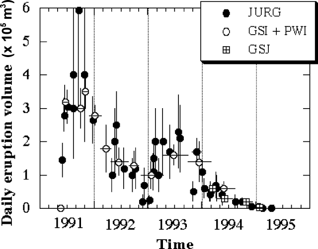 |
Figure 79. Daily eruption volume at Unzen, May 1991-April 1995, showing two distinct pulses of magma-supply. No effusion of lava has been observed since mid-February 1995. The total volume of magma erupted during this 4-year period was ~0.20 km3. Eruption volumes were estimated by Geological Party, Joint University Research Group (JURG), using photographs from daily helicopter inspections and theodolite surveys. Only aerial photographs were used by the Geographical Survey Institute (GSI), the Public Works Research Institute (PWRI), and the Geological Survey of Japan (GSJ) to calculate the volume changes. Courtesy of Setsuya Nakada. |
Volcanic gas emission decreased in April, such that no fume was observed from distant sites. Scientists from the Shimabara Earthquake and Volcano Observatory (SEVO), Kyushu University, installed mirrors for EDM and GPS stations near the top of the endogenous dome during April fieldwork. A sample from the dike on the top of the endogenous dome, which extruded at the end of 1994 and is the latest juvenile material, had a composition similar to lobe-13 samples collected in August 1994 (~65 wt.% SiO2); the specific gravity was ~2.46.
Only 15 microearthquakes beneath the dome and 10 tremor events were detected in March at the Japan Meteorological Agency seismograph 3.6 km SW of the dome. The same station detected 29 earthquakes and 18 tremor events in April. No pyroclastic flows were detected in March or April, but tiltmeters recorded upward movement of the summit on 9 and 24 March. SEVO noted small tremors on 8 and 15 April that were associated with minor tiltmeter changes; epicenters were several hundred meters W of the dome.
Geological Summary. The massive Unzendake volcanic complex comprises much of the Shimabara Peninsula east of the city of Nagasaki. An E-W graben, 30-40 km long, extends across the peninsula. Three large stratovolcanoes with complex structures, Kinugasa on the north, Fugen-dake at the east-center, and Kusenbu on the south, form topographic highs on the broad peninsula. Fugendake and Mayuyama volcanoes in the east-central portion of the andesitic-to-dacitic volcanic complex have been active during the Holocene. The Mayuyama lava dome complex, located along the eastern coast west of Shimabara City, formed about 4000 years ago and was the source of a devastating 1792 CE debris avalanche and tsunami. Historical eruptive activity has been restricted to the summit and flanks of Fugendake. The latest activity during 1990-95 formed a lava dome at the summit, accompanied by pyroclastic flows that caused fatalities and damaged populated areas near Shimabara City.
Information Contacts: Setsuya Nakada, Volcano Research Center - Earthquake Research Institute, University of Tokyo, Yayoi 1-1-1, Bunkyo-ku, Tokyo 113, Japan; Volcanological Division, Seismological and Volcanological Department, Japan Meteorological Agency (JMA), 1-3-4 Ote-machi, Chiyoda-ku, Tokyo 100 Japan.