Report on Pacaya (Guatemala) — May 1995

Bulletin of the Global Volcanism Network, vol. 20, no. 5 (May 1995)
Managing Editor: Edward Venzke.
Pacaya (Guatemala) Eruption on 1 June produces ashfall and lava flows
Please cite this report as:
Global Volcanism Program, 1995. Report on Pacaya (Guatemala) (Venzke, E., ed.). Bulletin of the Global Volcanism Network, 20:5. Smithsonian Institution. https://doi.org/10.5479/si.GVP.BGVN199505-342110
Pacaya
Guatemala
14.382°N, 90.601°W; summit elev. 2569 m
All times are local (unless otherwise noted)
Pacaya erupted between 0630 and 0700 on 1 June, sending up a 6-km-high plume. Hot ash burned vegetation and damaged radio-antenna equipment near the summit. A thin layer of ash extended a few kilometers from the vent, with ashfall reported 2.5 km N in San Francisco de Sales and 3.5 km W in El Patrocinio (figure 15). A plume visible at 0715 on GOES-8 satellite images was moving SE at ~19 km/hr, prompting a NOAA Volcano Hazard Alert at 1000. Analysis based on comparison of wind shear data and observed translation of the plume suggested that the plume rose to ~9 km altitude. Eddie Sanchez noted that venting ash destroyed the 1984 spatter cone (SEAN 10:03), called "El Hornito," located roughly midway between the N caldera rim (Cerro Chino) and the previously active MacKenney cone (figure 16). In place of El Hornito was a small crater venting lava, a substantial amount of which flowed S.
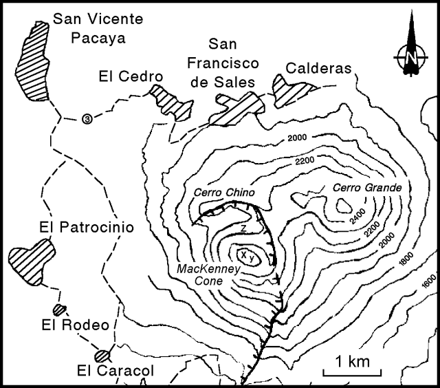 |
Figure 15. Sketch map of Pacaya and some nearby towns. Hachured arcuate line indicates the caldera rim. Letter "x" refers to MacKenney crater, "y" to the pre-1965 cone, and "z" to the 1984 spatter cone (El Hornito). Contour interval 100 m; contours around MacKenney cone are approximate. |
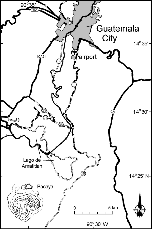 |
Figure 16. Location map showing Pacaya volcano, Guatemala City, the international airport, major roads, and other features. Contour lines are only shown around Pacaya (see figure 15). |
Otoniel Matias reported that on 10 June a small newly constructed spatter cone had collapsed. A news report described two strong explosions in the early afternoon and a thick column of smoke. Matias said that on 14 June more lava erupted, but compared to earlier phases there was less airborne ash and venting gases, and the plume reached only 150-200 m above the crater floor. In accord with this observation, SAB failed to image a plume at 0845 on 14 June; they estimate that a plume must have a height of >3,000 m for them to detect it. Matias went on to say that the 14 June eruption continued vigorously for two hours without pause. Lava continued to escape as of 16 June, and one or more lava flows had moved S for a distance of ~600 m.
Pacaya sits 30 km S of the center of Guatemala City (figure 15), with its population of >1.5 million. An eruption in 1989 produced a 4.5-km-tall eruption column that enlarged the MacKenney crater. Lava flows followed in 1990-91. Strong eruptive activity in June-August 1991 destroyed part of the MacKenney cone and damaged villages to the W. The volcano's olivine basaltic lavas have often flowed out of the collapsed SSW sector, traveling away from most of the nearby inhabited areas. The international airport (La Aurora) lies ~23 km from the crater and airplanes commonly fly over the volcano (figure 17).
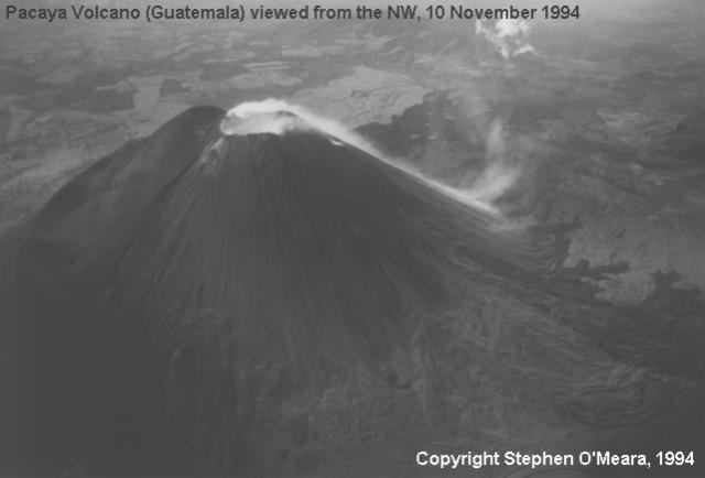 |
Figure 17. Aerial photograph of Pacaya viewed from the NW, 10 November 1994. Vapor rising from the MacKenney summit crater can be seen flowing down the S flank. Courtesy of Stephen O'Meara. |
Geological Summary. Eruptions from Pacaya are frequently visible from Guatemala City, the nation's capital. This complex basaltic volcano was constructed just outside the southern topographic rim of the 14 x 16 km Pleistocene Amatitlán caldera. A cluster of dacitic lava domes occupies the southern caldera floor. The post-caldera Pacaya massif includes the older Pacaya Viejo and Cerro Grande stratovolcanoes and the currently active Mackenney stratovolcano. Collapse of Pacaya Viejo between 600 and 1,500 years ago produced a debris-avalanche deposit that extends 25 km onto the Pacific coastal plain and left an arcuate scarp inside which the modern Pacaya volcano (Mackenney cone) grew. The NW-flank Cerro Chino crater was last active in the 19th century. During the past several decades, activity has consisted of frequent Strombolian eruptions with intermittent lava flow extrusion that has partially filled in the caldera moat and covered the flanks of Mackenney cone, punctuated by occasional larger explosive eruptions that partially destroy the summit.
Information Contacts: Eddie Sanchez and Otoniel Matias, Seccion Vulcanologia, INSIVUMEH, 7A Avenida 14-57, Zona 13, Guatemala City, Guatemala; Grace Swanson, Synoptic Analysis Branch - Room 401, NOAA/NESDIS, 5200 Auth Road, Camp Springs, MD 20746, USA.