Report on Fogo (Cabo Verde) — May 1995
Bulletin of the Global Volcanism Network, vol. 20, no. 5 (May 1995)
Managing Editor: Edward Venzke.
Fogo (Cabo Verde) Increased explosive activity; intense fumarolic emissions
Please cite this report as:
Global Volcanism Program, 1995. Report on Fogo (Cabo Verde) (Venzke, E., ed.). Bulletin of the Global Volcanism Network, 20:5. Smithsonian Institution. https://doi.org/10.5479/si.GVP.BGVN199505-384010
Fogo
Cabo Verde
14.95°N, 24.35°W; summit elev. 2829 m
All times are local (unless otherwise noted)
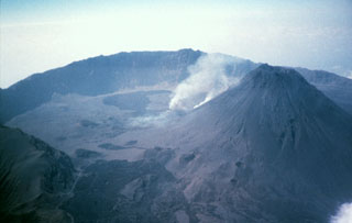
Eruptive activity that began at Fogo on 2 April generated lava flows throughout the month (BGVN 20:03 and 20:04). Approximately 1,300 people evacuated from the Cha Caldera following fire fountaining from a fissure on the SW flank of the Pico cone. Lava flows covered the small settlement of Boca de Fonte (figure 3) by 9 April, and were ~500 m from Portela village a week later.
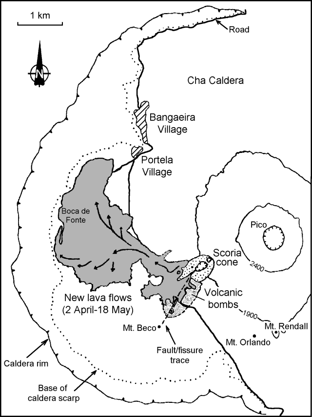 |
Figure 3. Map of Fogo (Cha Caldera) showing lava flows from the current eruption as of 18 May 1995. Courtesy of João Gaspar, Universidade dos Açores. |
Cape Verde scientists reported on 19 April that all of the flow-fronts had stopped, explosive activity had decreased, and emission of pyroclastic material was intermittent. By that time a small pit formed near the W flank of the scoria cone and sent pahoehoe lava W on top of the first aa flows. West of Monte Saia these new lava flows spread laterally and overrode the N and S margins of the earlier aa flows. On 10 May three more houses were covered by flows S of Boca de Fonte. Fumarolic activity from late April through early May remained intense along the main NE-SW fault. Inhalation of volcanic gases caused throat and eye irritations, headaches, and other complaints.
Following a request by the Cape Verde government, volcanologists from Azores University arrived at Fogo on 11 May to assess public health problems related to the eruption. Until 14 May pahoehoe and toothpaste lava flows continued advancing S of Boca de Fonte and towards Portela village, while gases rose continuously from the main vents. On 14 May at 1600 the activity increased and an ash cloud rose 500 m. Measurements made the next day at the end of a lava tube 2 km W of the main vent showed lava velocities of 2 m/minute. Ropy pahoehoe lavas formed at this stage. The lava flow-front 10 m away from the lava tube had a velocity of 2 m/hour. Starting at 1900, and continuing for at least 5 hours, explosions in the scoria cone crater ejected blocks to heights of 30 m; most fell near the crater rim.
Several profiles were made of the caldera on 16 May to evaluate CO2soil degassing using colorimetric tubes fixed in a 1-m-long probe. Values obtained 70 cm below the ground surface were always less than 2%. Ground temperatures changed from 67 to 115°C inside the SW craters where some explosions took place in the beginning of the eruption. Sulfur deposits could be observed in this section of the main fissure, but fumarolic activity was already very weak.
On the morning of 17 May dense clouds of gas and dust were released from the scoria cone while all the lava fronts appeared to be stationary. Through the afternoon explosive activity increased and strong explosions gave rise to discontinuous projections of spatter that reached 50 m high. Due to the explosions some large blocks of the crater wall collapsed and clouds of orange and red dust rose ~100 m. Streams of gases flowed down the SW slope of the scoria cone and reached the caldera wall on 18 May. People in the caldera felt nose and throat irritations more than 2 km from the main vents, making it impossible to approach without a gas mask. A strong sulfur smell was reported as far as Patim village, 8 km SW. On this day atmospheric samples were collected near the scoria cone. Chemical analysis of water from springs at Mosteiros (~9 km N) and wells in Sao Filipe (~15 km WSW) showed no contamination of the reservoirs by magmatic components.
Since the beginning of the eruption, lava flows have covered ~4.3 km2 of productive land, and preliminary data indicate an erupted volume of 22-35 x 106 m3. Boca de Fonte (population 56) was completely destroyed, and flow-fronts were 300 m from Portela as of 18 May. About 1,000 persons remain in shelters at Army camps in Sao Filipe, Patim, Achada Furna, and Mosteiros. During this eruption nobody was killed, but several needed medical assistance, mainly for respiratory problems due to inhalation of volcanic gas and dust.
Geological Summary. The island of Fogo consists of a single massive stratovolcano that is the most prominent of the Cape Verde Islands. The roughly circular 25-km-wide island is truncated by a large 9-km-wide caldera that is breached to the east and has a headwall 1 km high. The caldera is located asymmetrically NE of the center of the island and was formed as a result of massive lateral collapse of the older Monte Armarelo edifice. A very youthful steep-sided central cone, Pico, rises more than 1 km above the caldera floor to about 100 m above the rim. Pico, which is capped by a 500-m-wide, 150-m-deep summit crater, was apparently in almost continuous activity from the time of Portuguese settlement in 1500 CE until around 1760. Later lava flows, some from vents on the caldera floor, reached the eastern coast below the breached caldera.
Information Contacts: J.L. Gaspar, T. Ferreira, R. Coutinho, and G. Queiroz, Departamento Geociências, Universidad dos Açores, rue da Mae de Deus 58, 9500 Ponta Delgada, Açores, Portugal; A. Mota Gomes, Instituto Superior de Educação de Cabo Verde (ISE), Cape Verde.