Report on Lateiki (Tonga) — June 1995
Bulletin of the Global Volcanism Network, vol. 20, no. 6 (June 1995)
Managing Editor: Richard Wunderman.
Lateiki (Tonga) Eruption builds new island
Please cite this report as:
Global Volcanism Program, 1995. Report on Lateiki (Tonga) (Wunderman, R., ed.). Bulletin of the Global Volcanism Network, 20:6. Smithsonian Institution. https://doi.org/10.5479/si.GVP.BGVN199506-243070
Lateiki
Tonga
19.18°S, 174.87°W; summit elev. 43 m
All times are local (unless otherwise noted)
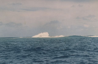
On 6 June the Hydrographic Office in Tonga notified the New Zealand Hydrographic Office that an eruption was in progress at Metis Shoal (figure 3). The NZ Hydrographic Office then issued a Long Range Navigation Warning to all shipping. The ship Obtfriesland reported the shoal in eruption while passing on 9 June at 1050. At least five volcanic ash aircraft advisories were issued by the Wellington Volcanic Ash Advisory Center on 12-13 June. The notices stated that the eruption began early on 12 June, apparently the time of the first plume report by an aircraft. Ash was reported up to 18-24 km. Drift directions of the plume changed in each notice, with estimated speeds of 28-46 km/hour.
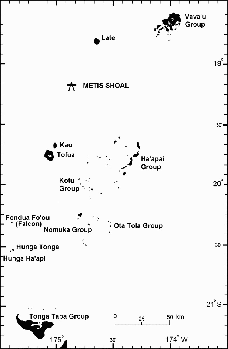 |
Figure 3. Map of the Tonga Islands, showing the island groups and location of Metis Shoal, which re-emerged as an island in June 1995. |
An island breached the surface ~12 June, but the growth of a lava dome above sea level was first observed on 14 June. A video taken on 14 June by a local tour operator (Allan Bowe), ~400-500 m away from the new island, was widely distributed by television news organizations. The video narrator noted that the water around the boat was discolored green. Based on the video and photographs, Brad Scott estimated that the dome was ~30 m high with a diameter of 150-180 m. The volume of the lava dome was estimated at ~1 x 10⁶ m3, giving a daily extrusion rate of ~1 x 10⁵ m3.
Ash-laden eruptions seen on the video discharged from two sources. The first was directed NW, apparently from the dome wall. The second generated stronger explosions vertically from the dome center to heights of 300-500 m. The NNE face of the dome was steaming vigorously from what appeared to be parallel vertical sources, probably fractures in the advancing flow front. The steam plume, originating from the N and S sides of the dome, was rising 500-800 m before being blown downwind for several kilometers.
By 20 June the lava dome was 240 x 280 m in size (67,200 m2) and ~54 m above sea level; the next day it was an estimated 200-500 m across and 50-80 m high. The volume of the dome was estimated at ~2.8 x 10⁶ m3, three times that on 14 June. The daily extrusion rate during 14-21 June was ~4 x 10⁶ m3, a 4-fold increase over the 6-14 June period.
During 20-21 June a white steam plume rose as high as 1-2 km, and occasional small explosions produced ash columns to ~500 m. The active vent was in the SE corner of the island. On the evening of 20 June, the growing NE front of the dome was incandescent, and some observers reported that the summit was pulsing 3-5 m vertically. A small lobe was extruded onto the top of the dome and the NE front of the dome was active. Phreatic explosions occurred at the flow front. The dome changed overnight on 20-21 June, moving downward and NE. The steep-sided lava dome split and subsided between 21 and 25 June. Another aviation volcanic ash advisory on 21 June noted a report of ash below 24 km in the vicinity of the volcano drifting SE at ~18-19 km/hour.
On 23 June the Tongan government asked the New Zealand government for advice on the eruption. As a result, Brad Scott (IGNS) joined a Royal New Zealand Air Force maritime patrol flight on 25 June. He reported that by 25 June the elliptical dome, ~300 x 250 m, elongate NNE, and ~50 m high, had stopped growing.Trending NW was a raised platform ~150 x 80 m, and 2-3 m above sea level. The lobe formerly on top of the dome had been displaced ~40-50 m NE and was lower than the highest point, which then stood on the S side. Blue fume emissions from a depression in the central part of the dome indicated a high SO2 content. A circular lobe of lava to the NE overlay a strongly ribbed flow front. Zones of discolored water (yellow-brown) extending outward from the volcano apparently represented submarine fumarolic discharge.
Scott traveled on a tugboat near the island on 28 June. Steam emissions had decreased appreciably since 21 June, but the dome profile appeared unchanged since the 25th, indicating a significant decline in the eruption rate. Assuming a diameter of 280 m and a height of 43 m on 28 June, the erupted volume was calculated to be ~3 x 10⁶ m3. No pumice has been observed, in contrast with past eruptions. The 1967 and 1979 events erupted dacitic pumice and formed low-angle tuff cones, which were soon eroded away. The current lava dome appeared solid in late June, and may resist erosion for some time.
Two other eruption locations reported by aircraft were investigated, but nothing was found; those sites were apparently the aircraft locations at the time of the observations. The Tongan government was advised to place a restricted access zone around the island, and was briefed about acid rain/fume, explosive outbursts, dome collapse, and the formation of further shoals.
Metis Shoal is located in the Tonga Islands about halfway between Kao and Late, ~50 km NNE of Kao (figure 3). Eight previous episodes of activity are known since 1851; new islands were created on at least three (1858, 1967, and 1979), and possibly five, of those occasions. The 1967-68 island appeared around 11 December 1967, and had submerged again by 19 February 1968 (Melson and others, 1970). In 1979, large pumice rafts were first seen in May between Tonga and Fiji. Metis was seen in strong eruption in June, with ash emission in July, and fumarolic activity in August. The island, named Late Iki by the Tongan government, disappeared in October 1979 (SEAN 04:05-04:08, 04:10, and 04:12; see Woodhall, 1979, for more details).
References. Melson, W.G., Jarosewich, E., and Lundquist, C.A., 1970, Volcanic eruption at Metis Shoal, Tonga, 1967-1968: description and petrology: Smithsonian Institution Press, Smithsonian Contributions to the Earth Sciences, no. 4, 18 p.
Woodhall, D., 1979, Cruise of the R.V. Balikula to investigate recent volcanic activity in Tonga, July 11-18, 1979: Fiji Ministry of Lands & Mineral Resources, Mineral Resources Division Report 14, 13 p.
Geological Summary. Lateiki, previously known as Metis Shoal, is a submarine volcano midway between the islands of Kao and Late that has produced a series of ephemeral islands since the first confirmed activity in the mid-19th century. An island, perhaps not in eruption, was reported in 1781 and subsequently eroded away. During periods of inactivity following 20th-century eruptions, waves have been observed to break on rocky reefs or sandy banks with depths of 10 m or less. Dacitic tuff cones formed during the eruptions in 1967 and 1979 were soon eroded beneath the ocean surface. An eruption in 1995 produced an island with a diameter of 280 m and a height of 43 m following growth of a lava dome above the surface.
Information Contacts: Brad Scott, Volcano Surveillance Manager, Institute of Geological & Nuclear Sciences, New Zealand; Bureau of Meteorology, Northern Territory Regional Office, POB 735, Darwin NT 0801, Australia.