Report on Soufriere Hills (United Kingdom) — July 1995

Bulletin of the Global Volcanism Network, vol. 20, no. 7 (July 1995)
Managing Editor: Richard Wunderman.
Soufriere Hills (United Kingdom) Steam and ash emissions from two vents in the summit crater
Please cite this report as:
Global Volcanism Program, 1995. Report on Soufriere Hills (United Kingdom) (Wunderman, R., ed.). Bulletin of the Global Volcanism Network, 20:7. Smithsonian Institution. https://doi.org/10.5479/si.GVP.BGVN199507-360050
Soufriere Hills
United Kingdom
16.72°N, 62.18°W; summit elev. 915 m
All times are local (unless otherwise noted)
Soufriere Hills volcano (figures 3 & 4) began erupting on 18 July from a fissure vent (Vent 1) within the summit crater (20:6). The initial small phreatic eruption spread minor ash around the island. The next day the airport on Montserrat issued a NOTAM after a reconnaissance flight at 0745 reported flying through volcanic ash. Seismicity and minor phreatic explosions continued in the following days (20:6).
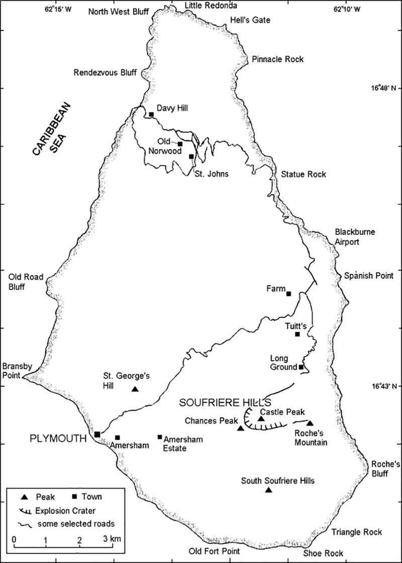 |
Figure 3. Map of Montserrat showing selected towns and features. |
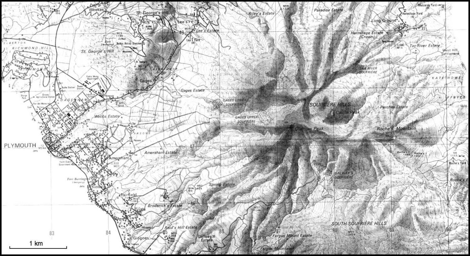 |
Figure 4. Shaded topographic map of Soufriere Hills volcano and the city of Plymouth. The summit is located on the SW crater rim at Chances Peak. Modified from the "Tourist Map of Montserrat" and reprinted with the permission of Lands & Survey Department, Plymouth, Montserrat. |
Another NOTAM on 26 July renewed the warning to aircraft and reported sporadic ash emissions. A second vent formed on 28 July (figure 5), and a third on 20 August. Gas samples taken in late July from fumaroles at Tar River and Galway's were unchanged from 1989. Samples of ash showed no juvenile components through at least 30 July. Seismicity in late July remained at about the same level as previously. A distinct odor of hydrogen sulfide (H2S) was detected in Plymouth . . . during late July, but sulfur dioxide (SO2) was not detected until 30 July.
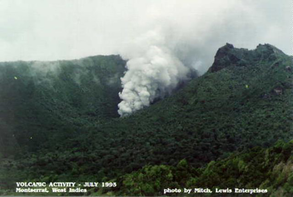 |
Figure 5. Photograph showing Vent 2 within the summit crater of Soufriere Hills volcano, 28 July 1995. View is to the WSW; the S wall of English's Crater is left of the vent. Castle Peak, to the right of the vent, is the youngest dome of the volcano. Courtesy of Mitch Lewis Enterprises and Tom Casadevall, USGS. |
Monitoring efforts. Monitoring of the eruptive activity and scientific advice to the Government of Montserrat are being provided by an international team of volcanologists. The first response to the crisis was provided by the Seismic Research Unit (SRU) at the University of the West Indies in Trinidad, which had maintained a seismic network on the island. Their team was later supplemented, at the request of Montserrat, by scientists from the U.S. Geological Survey (USGS), the Guadeloupe Volcano Observatory, and the United Kingdom. French scientists arrived on 25 July to sample gases. The USGS arrived on 26-27 July with additional seismometers, tiltmeters, and a correlation spectrometer (COSPEC).
The USGS team set up a seismic data analysis system to automatically locate earthquakes in near real-time, and made improvements to the existing seismic network. By 30 July, volcanologists were monitoring 10 channels of component signals from eight seismic stations; another station was added soon after. New telemetered tiltmeters at Spring Estate (2.5 km SW of the vents), Amersham (3.7 km WSW), and near Long Ground (2 km NE), were operational by 2 August.
Formation of Vent 2 on 28 July. A volcano-tectonic (VT) earthquake swarm that began at 0854 on 28 July lasted for >2 hours; instruments detected ~ 50 events of M >1. Coincident with this seismicity, a new vent opened SW of Castle Peak (Vent 2), along-strike with the fissure vent that had been intermittently active since 18 July. Vigorous jetting from the new vent at 1814 on 29 July, associated with ~ 22 minutes of tremor and earthquakes, occurred during heavy rainfall and was accompanied by a small mudflow. Following this episode, Vent 2 was estimated to be 1-2 m in diameter and was jetting steam and a small amount of fine ash ~ 100 m high with a loud roaring sound. During an overflight on 30 July Vent 1 was producing only wisps of steam, while Vent 2 continued to jet a large amount of steam and fine ash.
Because of increased steam emissions, on 28 July local authorities ordered an evacuation of the Long Ground area (figure 4). The evacuees returned to their homes the next morning. Two episodes of increased seismicity on 29-30 July caused no observable changes at the vent area. Small (mostly M
Low-level activity in early August. During 1-3 August there were fewer high-frequency, VT earthquakes, plus some long-period (LP) earthquakes. Preliminary locations for the LP events were at depths of 5-6 km, slightly deeper than the VT events. Emergent "cigar-shaped" signals, that probably correspond to vigorous steam venting, occurred a few times each day. Heavy rainfall on 3 August triggered a small, non-destructive mudflow during the night in a stream valley that runs through Plymouth. Normal infiltration of rain water may have been reduced by the relatively impermeable layer of fine ash that had accumulated on the upper slopes of the volcano.
Following 12 hours of unusually low seismicity, vigorous steam and ash emission began at 0852 on 4 August. This phreatic eruption lasted ~10 minutes, producing a dark, ash-laden column visible from most of the island. Seismicity associated with the eruption included several LP events. An aerial inspection revealed that the eruption had enlarged Vent 1 to ~10 m across and 10 m deep.
Concern was heightened after the phreatic eruption on 4 August and the increasing seismicity. As a precautionary measure, the elderly and infirm from the villages of Long Ground, Bramble Village, Bethel, Farms, and Trants were resettled on the N part of the island on 6 August. Aged and infirm in areas from Harris to Gages and N and S of the immediate area around Fort Ghaut in Plymouth, were also relocated to the N. Able-bodied residents of Long Ground were advised to move to shelters at night. Further restrictions may have been enforced during the next week.
Vent 2 was full of water on 5 August, apparently ground water forced from the volcano, and muddy water flowed from it through the Hot River drainage. On 6 August a large steam plume with minor ash rose from the vent area. By 7 August Vent 2 had grown ~ 20 m to the NW, in the direction of the 18 July fissure, the muddy water was gone, and jetting of steam and varying amounts of fine ash continued. The abscence of water emissions from the vent area after 7 August suggested that the volcano may have been "drying out," possibly due to increased heatflow.
Eighteen locatable earthquakes (M
Ground tilt recorded at Long Ground appeared to reverse on 5 August from steady deflation (down toward the vent area) since the station was installed, to apparent inflation (up toward the vent area). Vigorous venting on 6 August caused several microradians of tilt at two tiltmeters. Tiltmeters recorded small tilt events through 7 August, some of which seemed to correlate with periods of strong seismicity. However, there was no consistent pattern, suggesting that any deformation was relatively minor. A small tilt event occurred coincident with the 6-7 August seismic swarm.
Earthquakes declined on 9 August, but tremor caused by steam venting continued. At about 0715-0745 there was a relatively large steam venting episode. Vigorous steaming continued from Vent 2 on 10 August, but tremor intensity decreased and the number of small VT earthquakes increased to 1-2/hour. Most of the earthquakes were centered 2-5 km beneath the vent area. Seismicity was slightly lower during 10-11 August, with seven VT earthquakes, two individual low-frequency events, and three of four periods of continuous tremor lasting ~2 hours. On 10 August tilt appeared stable as measured by titlmeters and along a short leveling line near Broderick's Estate, ~3 km SW of the vent area, that was last measured ~10 years ago.
Reactivation of Vent 1. Vent 1 reactivated on 11 August and seemed to be emitting steam on the 12th. Steady steam emissions continued from both vents through 13 August. Seismicity was slightly lower on 11-12 August, with five small VT earthquakes and two periods of continuous tremor (~2 hours total). Increased gas venting around 1621 on 12 August triggered a swarm of VT events that continued into the next afternoon. The swarm consisted of >134 earthquakes, of which 38 were felt, the largest at around 0221 on 13 August (M ~3.5). Epicenters clustered 2-6 km beneath St. George's Hill (3 km WNW of the summit).
A mudflow from Vent 2 along the Hot River early on 12 August blocked the road for ~1 km between Tar River and Perche's Estates. Steady steam output from Vent 2 continued throughout 14 August. Steam emissions from Vent 1 were intermittent and occasionally changed composition. On 14-15 August there were three VT earthquakes, three B-type events, two low-frequency events, and five degassing episodes followed by tremor.
After three days of consistently lower activity (as of 11 August), daytime occupancy was recommended for able-bodied residents of the evacuated villages. However, the sick and bedridden were to remain at shelters. The reactivation of Vent 1 caused additional evacuations during 12-14 August from the previously mentioned villages, but able-bodied residents returned again on 15 August.
The seismographs recorded sustained low-frequency tremor from noon on 16 August through noon the next day. Degassing from Vent 2 continued at nominal to vigorous rates with occasional increases in acoustic intensity and changes in color of the output. Six of the 13 locatable VT earthquakes on 16-17 August were beneath Soufriere Hills; the others, including one felt strongly in Plymouth at 0143, were scattered within 4 km NE to NW of St. George's Hill. Vent 2 exhibited loud roars and intense venting coincident with heavy rainfall. The morning of 18 August was very overcast and inspection of the vents was not possible, but tremor continued, and there were six locatable VT earthquakes. During 18-19 August there was continuous low-frequency tremor and moderate emissions from Vent 2. Vent 1 was obscured for most of the period, but venting noise was generally low. Several low-amplitude extremely short-duration VT earthquakes on the Gages seismograph were buried within the background tremor signal, locatable events were generally 2-3 km beneath Soufriere Hills.
Tiltmeter observations remained within background noise level between 7 and 19 August. COSPEC measurements of SO2 flux taken from a helicopter after 30 July averaged 300 metric tons/day (t/d) until the morning of 6 August (table 1). After reaching a high of ~1,200 t/d on 6 August, values decreased and stabilized below an average of 200 t/d through 18 August.
Table 1. Summary of SO2 measurements at Soufriere Hills determined by COSPEC, 30 July-18 August 1995. Courtesy of the USGS.
| Date | COSPEC SO2 (t/d) | Comments |
| 30 Jul-03 Aug 1995 | 200-600 (average 300) | First flight on 30 July. Determined that the only plausible source is a degassing magma body. |
| 04 Aug 1995 | ~550 | Measurements spanned an episode of vigorous venting. |
| 06 Aug 1995 | ~1,200 | Morning measurement. |
| 06 Aug 1995 | ~250-300 | Later in the day. |
| 07-09 Aug 1995 | ~200 | -- |
| 10 Aug 1995 | ~245 ± 25 | -- |
| 11 Aug 1995 | ~190 ± 30 | -- |
| 12 Aug 1995 | -- | Wind not adequate for measurement |
| 14 Aug 1995 | ~150 ± 20 | -- |
| 16 Aug 1995 | ~163 ± 25 | -- |
| 17 Aug 1995 | ~111 ± 35 | -- |
| 18 Aug 1995 | ~180 ± 30 | -- |
An ash explosion on the morning of 20 August formed a third vent in the summit crater and prompted evacuations of up to 5,000 people. The observatory location was moved as a result, delaying the daily reports. Because this occurred near our deadline, details will be provided next month.
Geological Summary. The complex, dominantly andesitic Soufrière Hills volcano occupies the southern half of the island of Montserrat. The summit area consists primarily of a series of lava domes emplaced along an ESE-trending zone. The volcano is flanked by Pleistocene complexes to the north and south. English's Crater, a 1-km-wide crater breached widely to the east by edifice collapse, was formed about 2000 years ago as a result of the youngest of several collapse events producing submarine debris-avalanche deposits. Block-and-ash flow and surge deposits associated with dome growth predominate in flank deposits, including those from an eruption that likely preceded the 1632 CE settlement of the island, allowing cultivation on recently devegetated land to near the summit. Non-eruptive seismic swarms occurred at 30-year intervals in the 20th century, but no historical eruptions were recorded until 1995. Long-term small-to-moderate ash eruptions beginning in that year were later accompanied by lava-dome growth and pyroclastic flows that forced evacuation of the southern half of the island and ultimately destroyed the capital city of Plymouth, causing major social and economic disruption.
Information Contacts: VDAP, USGS; Seismic Research Unit, UWI; Montserrat EOC.