Report on Kanaga (United States) — August 1995
Bulletin of the Global Volcanism Network, vol. 20, no. 8 (August 1995)
Managing Editor: Richard Wunderman.
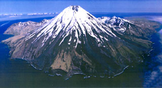
Kanaga (United States) Minor steaming from the summit area
Please cite this report as:
Global Volcanism Program, 1995. Report on Kanaga (United States) (Wunderman, R., ed.). Bulletin of the Global Volcanism Network, 20:8. Smithsonian Institution. https://doi.org/10.5479/si.GVP.BGVN199508-311110
Kanaga
United States
51.923°N, 177.168°W; summit elev. 1307 m
All times are local (unless otherwise noted)
Clouds obscured the volcano during much of the second half of July, preventing ground and satellite observations. Observers on Adak got a brief view on 14 July and reported light steaming from the summit. On 20 July an AVO geologist on Adak viewed Kanaga for several hours. As has been reported intermittently by U.S. Fish and Wildlife Service (FWS) observers since last fall, fumaroles high on the E and SE flank steamed vigorously and a hazy plume of steam and possibly volcanic gas emanated from the summit crater and drifted a few kilometers downwind. In contrast to other mountain peaks of similar elevation, most of Kanaga was dark and snow-free. One snow patch just below the summit was mantled by debris. It is not known if material mantling the cone is the result of possible activity in late June or merely wind-reworking of material deposited during the extended 1994 eruption. Clouds again obscured Kanaga through the first half of August, but FWS personnel on Adak observed minor steaming from the summit crater during 12-25 August.
Geological Summary. Symmetrical Kanaga stratovolcano is situated within the Kanaton caldera at the northern tip of Kanaga Island. The caldera rim forms a 760-m-high arcuate ridge south and east of Kanaga; a lake occupies part of the SE caldera floor. The volume of subaerial dacitic tuff is smaller than would typically be associated with caldera collapse, and deposits of a massive submarine debris avalanche associated with edifice collapse extend nearly 30 km to the NNW. Several fresh lava flows from historical or late prehistorical time descend the flanks of Kanaga, in some cases to the sea. Historical eruptions, most of which are poorly documented, have been recorded since 1763. Kanaga is also noted petrologically for ultramafic inclusions within an outcrop of alkaline basalt SW of the volcano. Fumarolic activity occurs in a circular, 200-m-wide, 60-m-deep summit crater and produces vapor plumes sometimes seen on clear days from Adak, 50 km to the east.
Information Contacts: Alaska Volcano Observatory (AVO), a cooperative program of a) U.S. Geological Survey, 4200 University Drive, Anchorage, AK 99508-4667 USA, b) Geophysical Institute, University of Alaska, PO Box 757320, Fairbanks, AK 99775-7320, USA, and c) Alaska Division of Geological & Geophysical Surveys, 794 University Ave., Suite 200, Fairbanks, AK 99709, USA.