Report on Ruapehu (New Zealand) — September 1995

Bulletin of the Global Volcanism Network, vol. 20, no. 9 (September 1995)
Managing Editor: Richard Wunderman.
Ruapehu (New Zealand) Large eruptions produce lahars and send plumes to over 10 km altitude
Please cite this report as:
Global Volcanism Program, 1995. Report on Ruapehu (New Zealand) (Wunderman, R., ed.). Bulletin of the Global Volcanism Network, 20:9. Smithsonian Institution. https://doi.org/10.5479/si.GVP.BGVN199509-241100
Ruapehu
New Zealand
39.28°S, 175.57°E; summit elev. 2797 m
All times are local (unless otherwise noted)
Following noteworthy "vent clearing" eruptions at Ruapehu (figure 17) on 29 June and 3 July, and phreatic eruptions in September, a series of larger eruptions began on 23 September. During the next week Ruapehu discharged plumes that were frequently reported by aviation sources to have reached at least 10 km. The following was compiled from Institute of Geological & Nuclear Sciences (IGNS) reports and aviation notices.
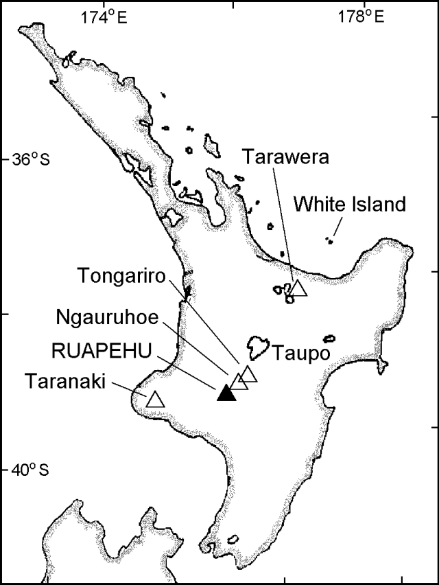 |
Figure 17. Index map of North Island, New Zealand, showing the location of Ruapehu and other volcanic centers. |
Precursory activity and minor eruptions. Many of Ruapehu's frequent small eruptions have been linked to high temperature in the crater lake. Unusually high lake temperatures (as well as other measured changes) also preceded the recent activity. During 1985-95 the surface temperature of Ruapehu's crater lake peaked at >40°C seven times; two of those peaks were in 1995. The early 1995 peak reached 55°C, the highest surface lake temperature recorded in 13 years (BGVN 20:01 and 20:05). The second 1995 peak reached roughly 44°C, the third highest seen in the 1985-95 interval. Key observations, including those from crater lake inspections carried out during visits from 25 May through 23 September (table 7) suggested a build-up in activity.
Table 7. Summary of key observations at Ruapehu, 25 May-23 September 1995. Prior to the larger eruptions observers reported that the lake was generally gray in color, often with sulfur slicks on its shore or surface; the lake began discharging water at Outlet sometime between 4 and 18 July. Courtesy of IGNS (IGNS Immediate Report (25 May-15 Aug 1995); IGNS Science Alert Bulletin (18-21 Sep 1995); Aviation report (23 Sep 1995).
| Date | Crater Lake Data | Other Observations |
| 25 May 1995 | 45.9°C at Outlet; ~0.7 m below overflow. | One very small eruption observed. |
| 16 Jun 1995 | 38.0°C at Outlet; ~1.5 m below overflow. | No evidence of recent eruptions. |
| 26 Jun 1995 | Very strong tremor for a few hours at one station. | -- |
| 29 Jun 1995 | Last ARGOS transmission. | Volcanic earthquake (M 3.2) correlated with an eruption. |
| 03 Jul 1995 | -- | Volcanic earthquake (M 2.4) correlated with an eruption. |
| 04 Jul 1995 | 33.0°C at Outlet; 0.5 m below overflow. | Intense steaming in the lake center. Two very small eruptions observed; evidence of larger eruptions that probably occurred on 29 June and 3 July. Small deformation. |
| 18 Jul 1995 | 31.0°C at Outlet. Discharge of 50 l/s. | Evidence for recent minor eruptions but no observed activity. |
| 15 Aug 1995 | 29.0°C at Outlet. Discharge of 5-10 l/s. | No evidence of recent activity; small deformation. |
| 18 Sep 1995 | Moderate vent-clearing explosive eruption at 0805 from within the lake. | Caused a flood, a lahar, and a small mudflow down the flanks; accompanying volcanic earthquake (ML 3.6). The lahar was the largest down the Whangahu river since 1975. |
| 20 Sep 1995 | 48°C at Outlet. Very large overflow. | New scoria bombs found; 15 small phreatic eruptions witnessed. |
| 20 Sep 1995 | -- | Eruption similar to 18 September, only smaller; accompanying volcanic earthquake (ML 3.2). |
| 20-21 Sep 1995 | Lake water chemistry indicates increased magma-water interaction. | Geodetic data show increased crater diameter. |
| 23 Sep 1995 | Major eruption began; column top reached over 10 km altitude. | -- |
A hydrophone and related acoustical detection components in the crater lake registered unusually high noise levels during late May, consistent with seismic activity. A moderate noise burst took place on 13 June, and relative quiet prevailed through 29 June. These data were communicated via the satellite-relayed ARGOS data system at 2-hour intervals; the last transmission (0800 on 29 June) came just prior to a M 3.2 volcanic earthquake and eruption that destroyed the ARGOS equipment.
Seismicity was at background levels from 15 May until just prior to the 29 June earthquake. The earthquake began at 0802 as a small 2-Hz signal followed by a 1-Hz signal. The main part of the earthquake, which also contained 2-Hz signal, started at 0821, and peaked between 0822 and 0824. After the main part of the earthquake, more signals centered around 1 and 2 Hz prevailed. The 2-Hz signals are common to both volcanic earthquakes and tremor at Ruapehu, suggesting that both may excite the same resonator.
Ruapehu's tremor typically has a dominant frequency of ~2 Hz and occurs almost constantly, often with no clear surface volcanic expression. Although not recorded at all stations, during 1995 and possibly longer, tremor has contained a previously unrecognized dominant frequency of 7 Hz with a consistent amplitude of 1 µm/s. During April, May, and late June, intervals of strong 2-Hz tremor dominated the seismic records. Very strong tremor took place for a few hours on 26 June. Tremor declined thereafter and remained low from early July through much of August.
Lake water increased in Cl and especially Mg ions closer to the eruption. The Mg/Cl ratio rose from values around 0.035 in early 1995 (BGVN 20:05), to the most recently reported value of 0.072 on 15 August (table 8); there was a further increase of unstated magnitude on 20-21 September (table 7). Prior to the eruption, the rise in Mg was thought to represent leaching from unweathered andesites. The increase in Cl, which reached greater levels than seen in at least 9 years, was thought to result from both large-scale evaporation and HCl input. The rise in Mg/Cl ratio represented the largest shifts seen since the large 1971 and 1975 eruptions. Shifts in the concentrations of K, Fe, and SO4 from samples collected on 18 July suggested increased input of SO2 into the vent-lake system rather than a water-rock equilibrium process in the vent. Although provisional, results for SO4 on 18 July suggested a 4.5% increase--the highest ever recorded for the lake.
Table 8. Ruapehu Crater Lake water analyses and temperatures at Outlet, 25 May-4 July 1995. Courtesy of IGNS.
| Date | Mg (ppm) | Cl (ppm) | Mg/Cl | Outlet Temp (°C) |
| 25 May 1995 | 385 | 7603 | 0.051 | 46 |
| 16 Jun 1995 | 427 | 7797 | 0.055 | 38 |
| 04 Jul 1995 | 514 | 7976 | 0.064 | 33 |
| 18 Jul 1995 | 551 | 8014 | 0.069 | -- |
| 15 Aug 1995 | 584 | 8154 | 0.072 | -- |
Deformation surveys on 4 July and 15 August confirmed only small measurable changes. This result suggested little or no magmatic movement in the upper part of the vent, in contrast with much of the other data in the same time interval. The limited deformation may have been a consequence of an open vent that allowed a small amount of magma to escape without measurable deformation. Measurable changes were apparently evident later (20-21 September, table 7).
Larger eruptions in late September. Ruapehu produced a series of larger eruptions during 23-30 September and later, continuing into October. Preliminary estimates suggested the eruption plumes reached 8-12 km heights as reported by aviation sources (table 7 and figure 18). The aviation reports and occasional satellite imagery typically noted plumes possibly extending as far as ~270 km from the summit (from an episode of eruptive bursts that were thought to have been more dense and ash-rich beginning at 1600 on 24 September). This particular series of bursts only initially reached low levels, but ash was said to have been lifted higher by induced cumulus convection, ultimately reaching a reported altitude of ~12 km. On subsequent days, the plume's typical maximum lateral extent was given as roughly 60 km.
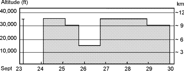 |
Figure 18. Histogram summarizing the height of column tops for Ruapehu eruptions, based on available aviation reports and IGNS Science Alert Bulletins. Courtesy of Nick Heffter, NOAA. |
For the 24-hour interval ending on 24 September (exact times undisclosed) observers at Ruapehu noted both small- and medium-sized steam-rich ash-bearing explosions, the largest of which had plumes that rose from 500 to over 1,500 m. On 24 September medium-sized explosions yielded a distinctive, though modest seismic signature and lesser explosions were not detectible. Near midnight on 24 September the number of volcanic earthquakes rose significantly; strong tremor roughly doubled in intensity compared to that morning; reflected seismic waves from numerous explosions yielded a confused signal.
Reports for 25 September (at 0900, 1700, and a summary the next day) noted that an eruption column had developed from many moderate-sized eruptions. With its top at 8-10 km altitude, the plume was blown into the E quadrant for several tens of kilometers, dropping ash 18 km E (Desert road; total accumulation, 1 mm), 30 km E (the Kaimanawa mountains), and 120 km E (traces at the coast). The ash deposited at Desert Road contained mainly particles of 10-250 µm size; 30-60% of the particles were juvenile. Significant amounts of ash had accumulated in the vent area but large blocks had been ejected less than ~1 km from the vent. Outlet was dry, but based on later observations, the inner crater still contained a lake.
At 0900 on 25 September a lahar flowed down the Whangaehu valley. The valley forms a key drainage that descends ESE from the crater, ultimately curving S and W to encircle Ruapehu's S flank; downstream parts of the Whangaehu Valley cross the Auckland-Wellington rail line near Tangiwai. Later the lahar declined in size, but it was noted as still continuing and sediment-laden at 1630, having eroded a stream bank upstream of the Tangiwai bridge. Another lahar flowed W of the crater down Mangaturuturu Valley.
At 1700 on 25 September, the volcanism during the previous 30 hours was described as episodic, punctuated by two cycles of increasing then decreasing intensity. Based on seismic data, the second cycle was not quite as vigorous as the first. In the night and morning of 25-26 September minor amounts of ash continued to fall over the volcano's E quadrant. Low-to-moderate tremor continued until at least 1700. Occasional explosions were large enough to be recorded seismically but were smaller than those in the morning of the previous day. Although during much of the day visual observations were hampered by cloud cover, at 0600-0700 on 26 September observers saw the plume drifting ESE. The plume was fed by numerous weak explosions and observers noted that minor amounts of ash fell throughout the night. Observers also noted that lahars flowing down the Whangaehu Valley were smaller than on the previous day. A very small lahar, deposited during an earlier event, was noted in the SE-flank Wahionoa Valley.
A SO2 flux measurement at 1600 on 26 September indicated an output of 2,600 +- 400 metric tons/day. Such high fluxes confirmed significant magmatic involvement in the eruption. Although cloud cover limited the visibility on much of 26 September, the low seismic activity during the day suggested explosions of modest size. From about 2300 through early the next morning tremor amplitude fluctuated, increasing up to moderate levels. After 0400 tremor coexisted with many volcanic earthquakes.
Visual observations made after sunrise on 27 September correlated tremor and earthquake increases to moderately vigorous eruptive activity. During this period (0600-0700) the earthquakes reached a size equivalent to those on 25 September. By about 0930 on 27 September, however, the earthquakes stopped and the eruption's size dropped. Earthquakes then remained undetected until at least 1700.
Aerial observers on 27 and 28 September saw that Crater Lake had been greatly reduced in size; although indistinct, the steaming surface had clearly dropped by tens of meters. They also saw a previously concealed terrace formed during the 1945 eruption and recognized a new small lahar deposit in a drainage on the NW flank (in the Whakapapaiti Valley). On 27 September observers reported no water in the upper Whangaehu Valley and viewers the next day stated that downstream at the Tangiwai bridge the water level had returned to normal.
During the 24 hours ending at 0930 on 28 September, moderate levels of seismicity prevailed, and three larger volcanic earthquakes took place in the 0215-0340 interval. These earthquakes may have been associated with discrete explosions. Other volcanic earthquakes at 0736 and 0839 were linked to mild puffs of ash-bearing steam rising from the crater.
Ruapehu's alert status was raised to Level 4 (table 9) on 25 September. As late as early October, there had been no reports of death or injury caused by the eruption. Because of potential hazard to aircraft, aviation and meteorological workers have carefully monitored the eruption, producing forecasts of the plume's transport and dispersal ("VAFTAD" modeling program, see BGVN 19:06) as well as the actual visible observations that have confirmed the height of the plume's top (figure 18).
Table 9. Scientific Volcano Alert Level system for New Zealand volcanoes. Note that the frequently active cone volcanoes of New Zealand (White, Ngāuruhoe, and Ruapehu) require definitions different from all other volcanic systems. Because of this, Alert Levels 1-4 are split into two parts: one for the frequently active cones and the other for reawakening systems. Courtesy of the IGNS.
| Alert Level | Phenomena Observed | Scientific Interpretation (Volc Status) |
| 0 | Typical background surface activity; seismicity, deformation, and heat flow at low levels. | Usual dormant, intra-eruption or quiescent state. |
| 1 | Departure from typical background surface activity. Minor phreatic activity. | Apparent seismic, geodetic, thermal, or other unrest indicators. Signs of volcano unrest. No significant eruption threat. |
| 2 | Increase from a low level of activity, accompanied by changes to monitored indicators. Significant change in level or style of ongoing eruptive activity. | Increase in seismicity, deformation, heat flow and/or other unrest indicators. Indications of intrusive processes. Local eruption threat. |
| 3 | Increased vigour of ongoing activity and monitored indicators. Significant local eruption in progress. | Commencement of minor eruptions at reawakening vent(s). Relatively high and increasing trends shown by unrest indicators. Increasing intrusive trends indicate real possibility of hazardous eruptions. |
| 4 | Significant change to ongoing activity and monitored indicators. Hazardous local eruption in progress. | Establishment of magmatic activity at reawakening vent(s), with acceleration of unrest indicators. Large-scale eruption now appears imminent. |
| 5 | Hazardous large volcanic eruption in progress. Destruction within the Permanent Danger (red) Zone. | Significant risk over wider areas. |
The late September eruption was widely covered in the news. According to Reuters (25 September), "A conservative Australian politician is linking nuclear testing by China and France to a string of earthquakes around the Pacific and volcanic eruptions in Montserrat and New Zealand's Mount Ruapehu." Although this connection was discounted by earth scientists, the accusation did reverberate in the media and parliaments world wide.
Geological Summary. Ruapehu, one of New Zealand's most active volcanoes, is a complex stratovolcano constructed during at least four cone-building episodes dating back to about 200,000 years ago. The dominantly andesitic 110 km3 volcanic massif is elongated in a NNE-SSW direction and surrounded by another 100 km3 ring plain of volcaniclastic debris, including the NW-flank Murimoto debris-avalanche deposit. A series of subplinian eruptions took place between about 22,600 and 10,000 years ago, but pyroclastic flows have been infrequent. The broad summait area and flank contain at least six vents active during the Holocene. Frequent mild-to-moderate explosive eruptions have been recorded from the Te Wai a-Moe (Crater Lake) vent, and tephra characteristics suggest that the crater lake may have formed as recently as 3,000 years ago. Lahars resulting from phreatic eruptions at the summit crater lake are a hazard to a ski area on the upper flanks and lower river valleys.
Information Contacts: C.J.N. Wilson, B.J. Scott, P.M. Otway, and I.A. Nairn, Institute of Geological & Nuclear Sciences (IGNS), Private Bag 2000, Wairakei, New Zealand; Bureau of Meteorology, Northern Territory Regional Office, POB 735, Darwin NT 0801, Australia; J. Heffter, National Oceanic and Atmospheric Administration (NOAA), Air Resources Laboratory SSMC3, Room 3151, 1315 East West Hwy., Silver Spring, MD 20910 USA; Synoptic Analysis Branch, NOAA/NESDIS, Room 401, 5200 Auth Road, Camp Springs, MD 20746, USA.