Report on Ruby (United States) — October 1995
Bulletin of the Global Volcanism Network, vol. 20, no. 10 (October 1995)
Managing Editor: Richard Wunderman.
Ruby (United States) Submarine eruption
Please cite this report as:
Global Volcanism Program, 1995. Report on Ruby (United States) (Wunderman, R., ed.). Bulletin of the Global Volcanism Network, 20:10. Smithsonian Institution. https://doi.org/10.5479/si.GVP.BGVN199510-284202
Ruby
United States
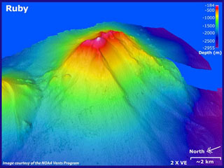
15.605°N, 145.572°E; summit elev. -174 m
All times are local (unless otherwise noted)
Ruby is a prominent, active submarine volcano in the Mariana Arc (2,300 km S of Tokyo) located NW of the Island of Saipan (figure 1). Although signs of an eruption were first noted by fishermen about 11 October, initial attempts to confirm their early observations failed. On 23 October fishermen reported that they could hear submarine explosions in that vicinity. A vessel from the Wildlife and Emergency Management Office of the Commonwealth of the Northern Mariana Islands confirmed these reports. An Associated Press news report stated that early on 25 October observers had seen dead fish and bubbles, and had smelled a sulfurous odor. On 27 October the Pacific Daily News reported the eruption site as 15°36'22"N, 145°34'33"E (15.6061°N, 145.5758°E). This spot clearly lies on the edifice identified by Bloomer and others (1989, p. 215) as Ruby....
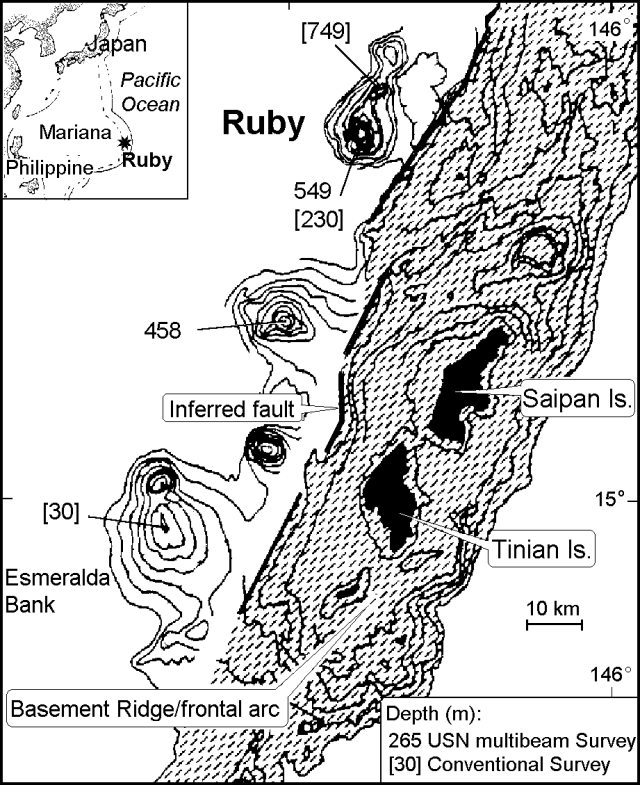 |
Figure 1. Index map and bathymetric map (depths in meters) showing seamounts near Saipan Island, including the known active centers Esmeralda Bank and Ruby (after Bloomer and others, 1989). |
Prior to the eruption, published estimates of the summit elevation suggested a 230-m depth, a refinement an earlier estimate of 549 m (Bloomer and others, 1989, p. 215). On 6 October 1995, the Pacific Daily News report stated the summit was measured at 185-m depth. This newly reported depth remains unconfirmed. According to Mike Blackford, on 23 October a marine depth finder reportedly measured a depth of ~60 m. Although this could be a reflection off the eruptive plume, in the absence of any discussion of instrument type and calibration, this depth remains equivocal.
According to Koyanagi and others (1993), the two seismic stations nearest the eruption were on Saipan (~50 km SE of Ruby) and Pagan islands (~130 km N of Saipan), both too distant to detect subtle seismic effects. Despite the lack of a nearby seismic station, tremor appeared on seismic records at the time of the eruption and the next day. Given the temporal coincidence between the eruption and the tremor, the two were probably associated.
A fish recovered at the eruption site was found to have small particles of ash in its gills and HVO researchers planned to analyze this ash. News of the eruption caused concern about a possible local tsunami and on 25 October, the Commonwealth of the Northern Mariana Islands issued an alert.
Evidence for Ruby's active status came from 1966 hydrophone data, followed later by dredging of extremely fresh volcanic rocks bearing plagioclase, clinopyroxene, and olivine (Bloomer and others, 1989).
References. Bloomer, S.H., Stern, R.J., and Smoot, N.C., 1989, Physical volcanology of the submarine Mariana and Volcano arcs: Bull. Volcanol., no. 51, p. 210-234.
Koyanagi, R., Kojima, G., Chong, F., and Chong, R., 1993, Seismic monitoring of earthquakes and volcanoes in the Northern Mariana Islands: 1993 summary report: Prepared for the Office of the Governor, Commonwealth of the Northern Mariana Islands, Capitol Hill, Saipan MP 96950 (revised 21 February 1993), 34 p.
Geological Summary. Ruby is a basaltic submarine volcano that rises to within about 200 m of the ocean surface near the southern end of the Mariana arc NW of Saipan. An eruption was detected in 1966 by sonar signals (Norris and Johnson, 1969). Submarine explosions were heard in 1995, accompanied by a fish kill, sulfurous odors, bubbling water, and the detection of volcanic tremor.
Information Contacts: Robert J. Stern, Center for Lithospheric Studies, University of Texas at Dallas, Box 830688, Dallas, TX 75083-0688 USA; Robert Koyanagi, USGS Hawaiian Volcano Observatory, Hawaii Volcanoes National Park, HI 96718, USA; Ramon C. Chong, Commonwealth of the Northern Mariana Islands (CNMI), Disaster Control Office, Capitol Hill, Saipan, MP 96950 USA; Mike Blackford, Pacific Tsunami Warning Center, 91-270 Fort Weaver Road, Ewa Beach HI 96706, USA; Associated Press; Pacific Daily News.