Report on Yellowstone (United States) — October 1995
Bulletin of the Global Volcanism Network, vol. 20, no. 10 (October 1995)
Managing Editor: Richard Wunderman.
Yellowstone (United States) New mud volcano, minor mud flow, and associated thermal features
Please cite this report as:
Global Volcanism Program, 1995. Report on Yellowstone (United States) (Wunderman, R., ed.). Bulletin of the Global Volcanism Network, 20:10. Smithsonian Institution. https://doi.org/10.5479/si.GVP.BGVN199510-325010
Yellowstone
United States
44.43°N, 110.67°W; summit elev. 2805 m
All times are local (unless otherwise noted)
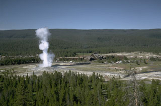
On the SW flank of Sour Creek resurgent dome W of Astringent Creek in the 0.6 Ma Yellowstone caldera, is an extensive, unnamed acid sulfate hydrothermal system (figures 2 and 3). Surface expression of the ~3 km2 thermal area consists of discontinuous high temperature altered ground, turbid springs, pools, seeps, fumaroles, mud pots, a large gas- and sulfur-rich acid lake, and numerous sublimated sulfur mound deposits interspersed among low-temperature forest-covered ground.
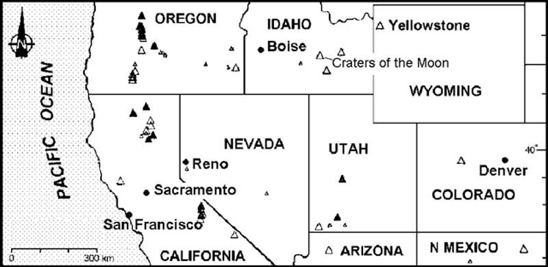 |
Figure 2. Index map of the western United States showing the location of Yellowstone Caldera. |
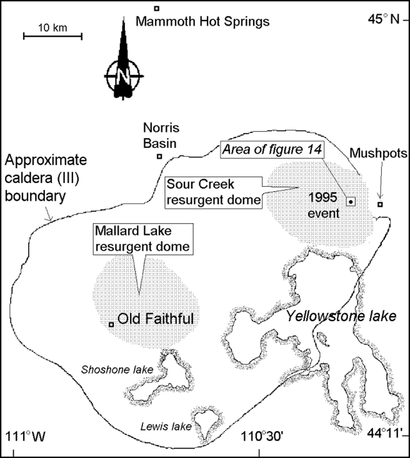 |
Figure 3. Sketch map of Yellowstone Caldera indicating the location of the recent thermal features described in this and an earlier report. |
During early 1990, a significant rise in temperature in the upper NW end of the hydrothermal system began killing old-growth pine trees. Within a year, a new super-heated fumarole emerged, blanketing the downed trees and roots with a layer of hydrothermally altered coarse sand from a directed blast to the N.
The temperature and volume of dry steam venting from the deep "shaft-like" vent steadily increased over the next three years, with the temperature reaching a maximum of 104.3°C on 8 October 1994, ~11°C higher than the local boiling point. The dynamic activity of the fumarole and surrounding hot ground was only monitored about twice a year over the three years following its 1990 inception due to its remote location and restricted access.
A similar progression was previously seen during 1985 in an area ~4.5 km to the E. This area, the upper E margin of the Mushpots thermal area, sits on the W flanks of Pelican Cone (BGVN 17:03). The progression went from new hot ground and dying mature forests, to the vigorous breakout of a dry, super-heated fumarole with progressively hotter temperatures over time, followed by sudden emergence of a large and violent mud volcano. Both the 1985 and recent thermal features had similar fluid compositions.
During 1992-94 the unnamed thermal area W of Astringent Creek developed a series of seven large craters that evolved as the Mushpots thermal area did in 1985. The craters were progressively younger towards the SW, ending at the site of the current new hot ground and fumarole (figure 4). In December 1993, National Park Service research geologist R. Hutchinson predicted that the newest superheated fumarole would soon evolve into a large mud volcano.
 |
Figure 4. Sketch map (scale approximate) showing the surface expression of an unnamed thermal area W of Astringent Creek in Yellowstone Caldera. Coordinates for map's center are at about 44°38'06"N, 110°16'44"W. Courtesy of R. Hutchinson. |
As a part of routine monitoring, the thermal area W of Astringent Creek was inspected on 7 June 1995. The former 104.3°C fumarole was replaced by a large vigorous mud pot with ejecta extensively scattered around it. In addition, two new smaller roaring fumaroles at or slightly above boiling point, three new moderate-sized churning caldrons (pits containing hot, agitated aqueous fluids), numerous smaller muddy pools, collapse pits, and frying-pan springs (audibly degassing springs) were apparent then. Extensive areas of unstable quicksand-like saturated ground made up of scalding mud were found under the fallen trees. Some regions were heavily encrusted with sulfate minerals or sulfur crystals; others were covered by baked organic matter on the pine forest's floor.
Extending NW from the largest parasitic churning caldron, below the new mud volcano crater, was a spectacular white kaoline clay mud flow (figure 4, dark shading and arrow showing flow direction). It spread rapidly to reach an average width of 13.8 m in the first 55 meters of its length in dead forest grove and eventually terminated 114 m from its source on the open, acid thermal-basin floor.
The relative freshness of the ejected mud and incorporated semi-coarse sandy material indicated that the super-heated fumarole transformed into the powerful mud volcano between mid-April and mid-May. The distribution of large mud bombs suggested that their trajectories reached 20-30 m above the crater rim. Ejecta were seen along the following compass bearings with the stated maximum distances from the crater: N, 13.6 m; E, 30.2 m; S, 25.4 m; and W, 12.1 m.
When visited on both 7 June and 9 September, the mud volcano still continued to throw mud 0.5-1.5 m high from dozens of points around the crater floor. The mud volcano crater was 13.5-m long, 11.3-m wide, and 3.9-4.9 m deep. A conservative estimate of the crater volume was 315 m3. The total area covered by the ejecta and crater was ~2,100 m2. In the SW quarter of the crater a large, slightly elevated projection was visible with an arcuate line of dry, white, probably super-heated fumarole vents.
The largest parasitic caldron had numerous points of ebullition in its irregularly shaped pool (maximum dimensions of 10.8 x 7.9 m), with a water level 0.7-1.4 m below the former forest floor. The churning water was near boiling, opaque, light tan in color, and partially covered with brown organic-rich foam derived from cooked plant material.
Each of the caldrons were interpreted as being parasitic to the mud volcano crater because they appeared to have evolved shortly after the initial fumarole collapse and then subsequently drained much of its fluids. This relationship seems to have rapidly lowered the crater floor, preventing the accumulation of a thick ejecta cone on the crater rim.
The mud volcano crater, parasitic features, vents, and the associated hot ground remain extremely dangerous and unstable. Additional alterations in the creation of new or enlarged springs, and perhaps even another mud volcano crater are anticipated. With respect to geologic hazards, the acid sulfate thermal area should be checked again in the near future. Photographs were taken on 7 June.
The Yellowstone Plateau volcanic field developed through three volcanic cycles spanning two million years and included some of the world's largest known eruptions. Eruption of the > 2,500 km3 Huckleberry Ridge Tuff ~2.1 million years ago (Ma) created a caldera more than 75 km long. The Mesa Falls Tuff erupted around 1.3 Ma, forming the 25-km-wide Island Park Caldera at the first caldera's W end. A 0.6 Ma eruption deposited the 1,000 km3 Lava Creek Tuff and associated caldera collapse created the rest of the present 45 x 75 km caldera (figure 3). Resurgent doming then occurred; voluminous (1,000 km3) intercaldera rhyolitic lava flows were erupted between 150,000 and 70,000 years ago. Phreatic eruptions produced local tephra layers during the early Holocene. Distinctive geysers, mud pots, hot springs, and other hydrothermal features within Yellowstone caldera helped lead to the establishment of the National Park in 1872.
Geological Summary. The Yellowstone Plateau volcanic field developed through three volcanic cycles spanning two million years that included some of the world's largest known eruptions. Eruption of the over 2,450 km3 Huckleberry Ridge Tuff about 2.1 million years ago created the more than 75-km-long Island Park caldera. The second cycle concluded with the eruption of the Mesa Falls Tuff around 1.3 million years ago, forming the 16-km-wide Henrys Fork caldera at the western end of the first caldera. Activity subsequently shifted to the present Yellowstone Plateau and culminated 640,000 years ago with the eruption of the over 1,000 km3 Lava Creek Tuff and the formation of the present 45 x 85 km caldera. Resurgent doming subsequently occurred at both the NE and SW sides of the caldera and voluminous (1000 km3) intracaldera rhyolitic lava flows were erupted between 150,000 and 70,000 years ago. No magmatic eruptions have occurred since the late Pleistocene, but large hydrothermal events took place near Yellowstone Lake during the Holocene. Yellowstone is presently the site of one of the world's largest hydrothermal systems, including Earth's largest concentration of geysers.
Information Contacts: Roderick A. Hutchinson, National Park Service, P.O. Box 168, Yellowstone National Park, Wyoming 82190, USA.