Report on Rabaul (Papua New Guinea) — December 1995

Bulletin of the Global Volcanism Network, vol. 20, no. 11 (December 1995)
Managing Editor: Richard Wunderman.
Rabaul (Papua New Guinea) Small ash-bearing emissions from Tavurvur
Please cite this report as:
Global Volcanism Program, 1995. Report on Rabaul (Papua New Guinea) (Wunderman, R., ed.). Bulletin of the Global Volcanism Network, 20:11. Smithsonian Institution. https://doi.org/10.5479/si.GVP.BGVN199512-252140
Rabaul
Papua New Guinea
4.2459°S, 152.1937°E; summit elev. 688 m
All times are local (unless otherwise noted)
Throughout most of November 1995 the two recently active centers remained quiet, with Tavurvur emitting only steam and Vulcan not emitting any visible vapor (figure 24). Then on 28 November, Tavurvur suddenly began erupting, creating a parasitic crater. Vulcan continued to remain quiet throughout December.
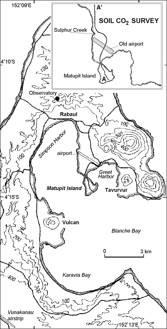 |
Figure 24. Index map of Rabaul and detail of soil CO2 transect. Elevation contours given in meters; base map after Johnson (1995). |
The volume of Tavurvur's faint blue vapor emissions seemed to increase in the weeks prior to 28 November. On the morning of the eruption an impressive white steam cloud stood several hundred meters above Tavurvur's summit. The new eruption, which was preceded by weak roaring sounds, started at about 1020, and initially consisted of forceful emissions of gas and dark ash at 2-6 minute intervals. Those emissions lacked explosion sounds; they rose 400-800 m above the crater rim and blew over a broad arc between the SE and SW, resulting in fine ashfall both onshore and over the sea. No ashfall reached Kokopo, 25 km SE. The next day, 29 November, two intervals of stronger emission took place (at 1200-1300 and 1415-1430), sending columns ~1 km above the summit.
An aerial inspection on 30 November revealed a new crater on the 1994-95 crater's SSE rim. Although the 1994-95 crater displayed no new activity, fumaroles were particularly active along its E walls. An old explosion crater along the base of Tavurvur's S flank, in which 6 people were killed in 1990 by inhalation of carbon dioxide, was releasing weak-to-moderate emissions of white vapor from its N to E walls. Directly downslope and immediately offshore of this explosion crater a spring had become considerably more active since the 1994 eruption; during the 30 November aerial inspection it was prominent, giving off a strong stream of rusty brown water. During November and December, ground deformation remained low.
Tavurvur discharged dark ash clouds in December, typically at 3-6 minute intervals, that rose 400-1,000 m above the summit. On 2 December two ash clouds rose to 1.5-2 km. The second brought intense lightning causing minor damage to home appliances in Rabaul Town (figure 24). On 5 December, a particularly loud explosion, heard 30-40 km away, accompanied the discharge of an ash cloud that rose to 1.2 km. Additional loud explosions accompanied dense ash clouds that rose to 1-1.2 km; these took place during December as follows: 11th (1 time), 13th (1), 14th (4), 18th (1), 23rd (1), 24th (1), and 29th (2). Moderate-sized clouds blew SE, and very fine ash occasionally fell both in Kokopo and, due to shifting winds, in Rabaul Town. On December nights, observers saw incandescent fragments and during the second half of the month they heard occasional deep roaring noises.
Seismicity. November seismicity generally remained low, but was punctuated by 11 high- and 42 low-frequency events. Eight of the high-frequency events were located. Five occurred within the caldera's seismically active elliptical fault zone, in the NE (1 event), W (1), and S (3) quadrants. Although one of the extra-caldera events was centered S of the caldera, two events were located immediately to the caldera's NE, an area where the bulk of the high-frequency earthquakes have occurred in the past few months. One of these two events, ML 3.0 on 24 November, produced a felt intensity of MM III at Rabaul Town.
Of the 42 low-frequency earthquakes during November, 17 came from around Tavurvur volcano. Two of these occurred in late October, and 9 others in November prior to the 28 November eruption. The last time such events appeared was during the eruptive activity in March 1995. The other 25 low-frequency earthquakes not centered around Tavurvur were more difficult to locate accurately due to emergent waveforms and fewer stations outside the caldera. Many may have originated immediately N of the caldera. On 10 November a low-frequency earthquake centered 7-8 km outside of the caldera was strong enough to trigger aftershocks.
During December, seismic instruments detected 30 high-frequency earthquakes, 684 low-frequency earthquakes, and 488 explosion events. Instruments also recorded occasional discontinuous non-harmonic tremors. About 70% of the high frequency earthquakes occurred during 4-6 December. The five located events had epicenters in either the S part of the caldera's seismically active zone (the largest one, M 2.7), NE of the caldera (two events), or within the caldera. All of the seismic explosions and most low-frequency earthquakes originated at Tavurvur; the 20 exceptions originated farther NW and took place at the end of the month.
Fumarole and soil sampling. During 21-27 November, rainwater, water from hot springs, and gases from subaerial and submarine fumaroles were sampled at 13 sites (table 3). Compared to Vulcan, fumaroles at Tavurur displayed relatively high temperature, low pH, and high conductivity. Hot springs sampled near the shore of Greet Harbor were slightly acidic and comparatively conductive. All samples were more acid than those assessed prior to the 1994 eruption episode.
Table 3. Summary of fumarole and hot spring sampling at Rabaul Caldera, 21-27 November 1995. Courtesy of RVO.
| Location | Number of samples/type | Temp (deg C) | pH | Electrical conductivity (mS/cm) |
| Tavurvur | 3/fumarole | 202-98.9 | 1.21-3.53 | 0.327-10.4 |
| Vulcan | 1/fumarole | 99.8 | 5.28 | 0.0758 |
| Rabalanakaia | 1/fumarole | 99.3 | 3.20 | 0.444 |
| Vulcan | 1/hot spring | 99.2 | 5.98 | 73.3 |
| Greet Harbor shore | 4/hot spring | 62.6-84.8 | 5.89-6.66 | 52.9-53.8 |
| Sulphur Creek | 1/hot spring | N.D. | 6.21 | 4.29 |
| Rabaul | 1/rainwater | N.D. | 6.06 | N.D. |
A soil CO2 survey E of Simpson Harbor (figure 24) showed that CO2 concentrations varied widely, 0.4-20% (figure 25). As reported by Mori and McKee in 1987, the CO2 concentrations peaked along the seismically active fault zone (near the old airport), some distance from either Tavurvur or Vulcan. Other anomalously high concentrations were seen at the Matupit causeway and Sulphur Creek. Low concentrations were seen at other places, including Matupit Island.
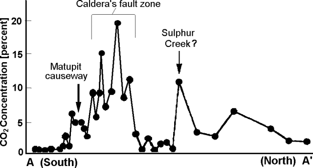 |
Figure 25. Soil CO2 concentrations at Rabaul Caldera along transect A-A'. Courtesy of RVO. |
Isotopic analysis of six selected samples along the profile found that 13C ranged from -29.8 to -18.4 per mil suggesting chiefly biogenic contributions. A mixing process with a minor contribution of volcanogenic CO2 might also account for the wide range of ratios seen. High soil CO2 levels could be related to the effects of a higher thermal gradient along active fractures and faults.
Geological Summary. The low-lying Rabaul caldera on the tip of the Gazelle Peninsula at the NE end of New Britain forms a broad sheltered harbor utilized by what was the island's largest city prior to a major eruption in 1994. The outer flanks of the asymmetrical shield volcano are formed by thick pyroclastic-flow deposits. The 8 x 14 km caldera is widely breached on the east, where its floor is flooded by Blanche Bay and was formed about 1,400 years ago. An earlier caldera-forming eruption about 7,100 years ago is thought to have originated from Tavui caldera, offshore to the north. Three small stratovolcanoes lie outside the N and NE caldera rims. Post-caldera eruptions built basaltic-to-dacitic pyroclastic cones on the caldera floor near the NE and W caldera walls. Several of these, including Vulcan cone, which was formed during a large eruption in 1878, have produced major explosive activity during historical time. A powerful explosive eruption in 1994 occurred simultaneously from Vulcan and Tavurvur volcanoes and forced the temporary abandonment of Rabaul city.
Information Contacts: Ben Talai, H. Patia, D. Lolok, and C. McKee, RVO; N. M. Perez and H. Wakita; University of Tokyo, Earth Chemistry, Bunkyo-ku, Tokyo 113 Japan.