Report on Fogo (Cabo Verde) — December 1995
Bulletin of the Global Volcanism Network, vol. 20, no. 11 (December 1995)
Managing Editor: Richard Wunderman.
Fogo (Cabo Verde) Eruption of 2 April through 28 May covered over 6 square kilometers of land
Please cite this report as:
Global Volcanism Program, 1995. Report on Fogo (Cabo Verde) (Wunderman, R., ed.). Bulletin of the Global Volcanism Network, 20:11. Smithsonian Institution. https://doi.org/10.5479/si.GVP.BGVN199512-384010
Fogo
Cabo Verde
14.95°N, 24.35°W; summit elev. 2829 m
All times are local (unless otherwise noted)
The eruption that began on 2 April (BGVN 20:04 and 20:05) ended on or about 28 May, according to V. Martins. New lava flows covered ~6.3 km2 of land. The total volume of lava extruded was ~60-100 x 106 m3, assuming lava flow thicknesses of ~9-15 m; the known range was from 1 to >20 m. Based on six major-element XRF analyses, the lava flow erupted during the first night (3 April) was determined to be a differentiated kaersutite-bearing phonotephrite (IUGS system), whereas later lava flows and spatter were more primitive tephrite basanite.
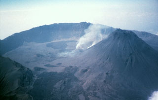
Fogo Island consists of a single massive volcano with an 8-km-wide caldera breached to the E. The central cone was apparently almost continuously active from the time of Portuguese settlement in 1500 A.D. until around 1760. The June-August 1951 eruption from caldera vents S and NW of the central cone began with ejection of pyroclastic material.
Geological Summary. The island of Fogo consists of a single massive stratovolcano that is the most prominent of the Cape Verde Islands. The roughly circular 25-km-wide island is truncated by a large 9-km-wide caldera that is breached to the east and has a headwall 1 km high. The caldera is located asymmetrically NE of the center of the island and was formed as a result of massive lateral collapse of the older Monte Armarelo edifice. A very youthful steep-sided central cone, Pico, rises more than 1 km above the caldera floor to about 100 m above the rim. Pico, which is capped by a 500-m-wide, 150-m-deep summit crater, was apparently in almost continuous activity from the time of Portuguese settlement in 1500 CE until around 1760. Later lava flows, some from vents on the caldera floor, reached the eastern coast below the breached caldera.
Information Contacts: Richard Moore, U.S. Geological Survey, Mail Stop 903, Federal Center Box 25046, Denver, CO 80225 USA; Frank Trusdell, U.S. Geological Survey, Hawaiian Volcano Observatory, Hawaii National Park, HI 96718, USA; Veronica Carvalho Martins, U.S. Embassy, Rua Hoji Ya Henda 81, C.P. 201, Praia, Cape Verde; Arrigo Querido, INGRH Servicos Estudos Hidrologicos, C.P. 367, Praia, Cape Verde.