Report on Karangetang (Indonesia) — January 1996

Bulletin of the Global Volcanism Network, vol. 21, no. 1 (January 1996)
Managing Editor: Richard Wunderman.
Karangetang (Indonesia) Small ash plumes, incandescent ejecta, and increased seismicity
Please cite this report as:
Global Volcanism Program, 1996. Report on Karangetang (Indonesia) (Wunderman, R., ed.). Bulletin of the Global Volcanism Network, 21:1. Smithsonian Institution. https://doi.org/10.5479/si.GVP.BGVN199601-267020
Karangetang
Indonesia
2.781°N, 125.407°E; summit elev. 1797 m
All times are local (unless otherwise noted)
On 9 and 16 November "thunderclaps" were heard from the summit. A gray plume 500 m high was observed, and incandescent ejecta rose 10-50 m above the summit at night. On 17 December thunderclaps were heard again and ejecta rose 100 m above the summit. Seismicity increased from 26 October until the end of 1995. Daily counts of deep volcanic (A-type) earthquakes fluctuated up to 116 (figure 3).
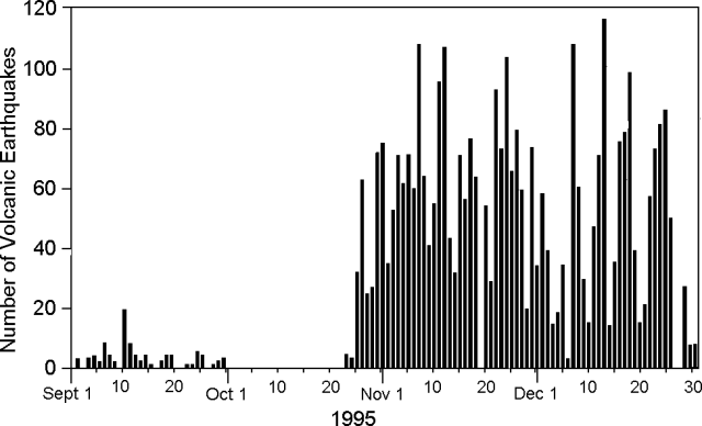 |
Figure 3. A-type seismicity at Karangetang, September-December 1995. Courtesy of VSI. |
Geological Summary. Karangetang (Api Siau) volcano lies at the northern end of the island of Siau, about 125 km NNE of the NE-most point of Sulawesi. The stratovolcano contains five summit craters along a N-S line. It is one of Indonesia's most active volcanoes, with more than 40 eruptions recorded since 1675 and many additional small eruptions that were not documented (Neumann van Padang, 1951). Twentieth-century eruptions have included frequent explosive activity sometimes accompanied by pyroclastic flows and lahars. Lava dome growth has occurred in the summit craters; collapse of lava flow fronts have produced pyroclastic flows.
Information Contacts: Wimpy S. Tjetjep (Director), Volcanological Survey of Indonesia (VSI), Jalan Diponegoro 57, Bandung, Indonesia.