Report on Hokkaido-Komagatake (Japan) — February 1996
Bulletin of the Global Volcanism Network, vol. 21, no. 2 (February 1996)
Managing Editor: Richard Wunderman.
Hokkaido-Komagatake (Japan) Tremor and extension precede early March phreatic eruption
Please cite this report as:
Global Volcanism Program, 1996. Report on Hokkaido-Komagatake (Japan) (Wunderman, R., ed.). Bulletin of the Global Volcanism Network, 21:2. Smithsonian Institution. https://doi.org/10.5479/si.GVP.BGVN199602-285020
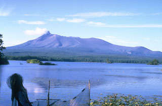
Hokkaido-Komagatake
Japan
42.063°N, 140.677°E; summit elev. 1131 m
All times are local (unless otherwise noted)
In the early evening of 5 March, >=6 minutes of large amplitude volcanic tremor registered and during the night an eruption began. The monthly record of earthquakes from 1966 until the eruption showed little in the way of a diagnostic rise prior to the eruption (figure 1). The above mentioned tremor was detected at the local Japan Meteorological Agency (JMA) seismic station (4.1 km WSW from the crater). Tremor was also noted by Usu Volcano Observatory (UVO), which maintains five seismic stations. On 5 March UVO recorded 5 minutes of premonitory tremor and an abnormally high number (> 10) of small volcanic earthquakes. Prior to the heightened seismicity, UVO researchers found continuous extension of Komaga-take's 1929 crater area begining in 1989, and their leveling survey in November 1995 showed a reversal from subsidence to uplift.
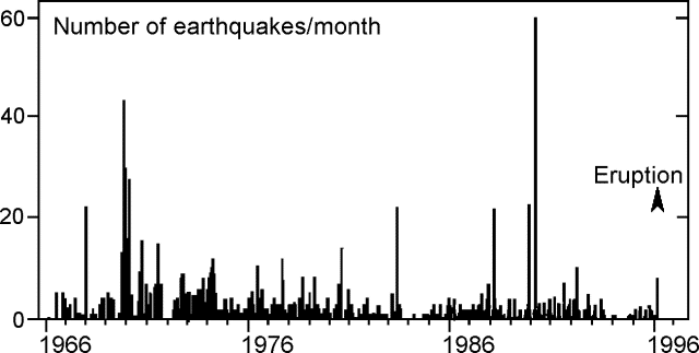 |
Figure 1. Monthly number of earthquakes of Komaga-take recorded at JMA's local seismic station in the years 1966-96. An eruption took place in early March 1996. Courtesy of JMA. |
On the morning of 6 March JMA reported that a white plume rose to 150 m above the summit and ashfall was visible for >10 km from the summit on the SSE flank. According to Tad Ui, who made observations from a helicopter during the morning of 6 March, steam-dominated eruption clouds rose from inside the craters of the 1929 eruption and also from new, 100-m-long, N-S trending fissures S of the craters. He estimated the cloud height at around 400 m. Ashfall covered new snow; no mudflows were observed. Videos taken around this time by the press and local residents showed violent, gray, ash-laden clouds jetting from newly formed fissures.
On 8 March, a white-colored plume was 900 m above the summit. By 12 March, eruptive activity declined. Post-eruption seismicity was weak: tremor was not observed from 5 March to as late as 10 March, and after 6 March small earthquakes occurred several times a day.
An aviation notice on 7 March stated that the top of the ash cloud was at ~1,500-m altitude (~300 m above the summit) and drifting SE; a notice the next day reported ash to ~1,700 m altitude drifting W. Notices were again issued on 13 and 19 March for ash clouds to ~1,300-m altitude.
Ui and other scientists from Hokkaido University will analyze new products; preliminary analysis suggested that the initially erupted tephra contained little fresh glass, and other magmatic materials appeared absent. The mass of tephra erupted in this event was estimated at ~25,000 tons.
Residents evacuated the night of 5 March were permitted to return on 8 March. Small phreatic eruptions of the kind witnessed beginning on 5 March 1996 could be precursors to larger explosions. Phreatic eruptions were observed during June 1919, and in June 1929, prior to larger events.
Geological Summary. Much of the truncated Hokkaido-Komagatake andesitic volcano on the Oshima Peninsula of southern Hokkaido is Pleistocene in age. The sharp-topped summit lies at the western side of a large breached crater that formed as a result of edifice collapse in 1640 CE. Hummocky debris avalanche material occurs at the base of the volcano on three sides. Two late-Pleistocene and two Holocene Plinian eruptions occurred prior to the first historical eruption in 1640, which began a period of more frequent explosive activity. The 1640 eruption, one of the largest in Japan during historical time, deposited ash as far away as central Honshu and produced a debris avalanche that reached the sea. The resulting tsunami caused 700 fatalities. Three Plinian eruptions have occurred since 1640; in 1694, 1856, and 1929.
Information Contacts: Tadahide Ui, Hokkaido University, Grad School Sci., Kita-ku, Sapporo 060 Japan; Usu Volcano Observatory (UVO), Faculty of Science, Hokkaido University, Sohbetsu-cho, Usu-gun, Hokkaido 052-01 Japan; Volcanological Division, Seismological and Volcanological Dept, Japan Meteorological Agency (JMA), 1-3-4 Ote-machi, Chiyoda-ku, Tokyo 100 Japan; Setsuya Nakada, Volcano Research Center, Earthquake Research Institute, University of Tokyo, Yayoi 1-1-1, Bunkyo-ku, Tokyo 113, Japan (URL: http://www.eri.u-tokyo.ac.jp/VRC/index_E.html); Bureau of Meteorology, Darwin, Australia.