Report on Soufriere Hills (United Kingdom) — February 1996

Bulletin of the Global Volcanism Network, vol. 21, no. 2 (February 1996)
Managing Editor: Richard Wunderman.
Soufriere Hills (United Kingdom) Increasingly rapid dome growth
Please cite this report as:
Global Volcanism Program, 1996. Report on Soufriere Hills (United Kingdom) (Wunderman, R., ed.). Bulletin of the Global Volcanism Network, 21:2. Smithsonian Institution. https://doi.org/10.5479/si.GVP.BGVN199602-360050
Soufriere Hills
United Kingdom
16.72°N, 62.18°W; summit elev. 915 m
All times are local (unless otherwise noted)
As reported in Montserrat Volcano Observatory (MVO) Scientific Reports, during February the growing dome became higher than Castle Peak and was visible on the volcano's W margins. Based on qualitative estimates, during the third week of February and early March the dome's growth probably reached the highest rates seen since extrusion began around 16 November 1995 (BGVN 20:11/12).
Dome growth and visible observations. As the dome enlarged, the focus of its growth migrated. During 1-7 February the dome's N side grew upward, and the S side grew outward. The dome's N side first became visible from the volcano's W margins beginning on 31 January. Under clear conditions on 2 February it was confirmed that this side of the dome had grown higher than Castle Peak. On 4 February this side of the dome reached a height equal to adjacent parts of the crater wall; talus from the dome's N side filled the adjacent moat and began piling up against the crater wall.
Although low cloud cover generally hampered visibility during the week of 8-14 February, observations around 9 February indicated slowed growth on the N and S coupled with a shift in the focus of activity to the dome's W side. On 11 February a spine was seen in the dome's central sector; its height then was equal to the dome's N side. That day, talus made contact with the crater wall around much of the dome. On 12 February a late morning helicopter flight allowed observers to see a small pyroclastic flow created as debris from the central dome avalanched S. Later in the week, growth took place on the dome's SE side and, in the form of two new protrusions, on the dome's W side.
A second consecutive week of low cloud cover occurred, 15-21 February, and by the end of this interval it was learned that the dome's SE side included a large whaleback-shaped lobe. This new lobe grew to reach the size of the southern whaleback, a lobe emplaced around 19 January (figure 8). The new lobe (not shown on figure 8) was the source of comparatively few rockfalls, and therefore was considered to be relatively massive and coherent. In contrast, frequent rockfalls fell down off the dome's central region and NW side and by the end of the week this area became the focus of growth. The moat's W margin, at the base of Gage's wall (figure 8), received considerable debris. Previously, this area had been the last part of the moat's W margin without appreciable debris.
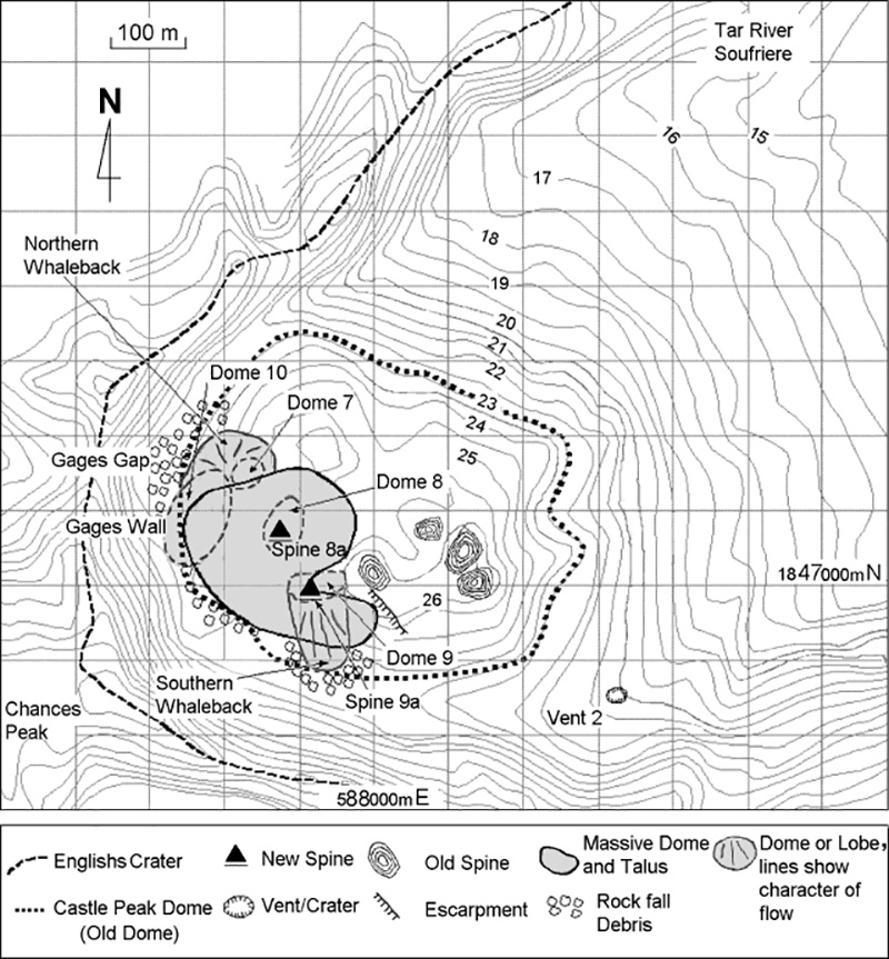 |
Figure 8. Soufriere Hills dome map for 25 December 1995 through 31 January 1996. Contour interval is 50 feet; values shown are in hundreds of feet (100 feet = 30.48 m). Although contours are unavailable for areas on the new dome, during February it had reached higher than the old Castle Peak dome and was visible through Gages Gap on from the W slope. Courtesy of MVO. |
During the week of 22-28 February, the dome growth rate, which was estimated qualitatively, may have been the highest since extrusion began. High steam and gas fluxes also prevailed. Although the resulting plumes thwarted aerial photo-documentation, the dome grew in both vertical and horizontal directions. Semi-continuous rockfalls from specific zones indicated growth in a pattern similar to the previous week. Specifically, most 22-28 February rockfalls came from the dome's central region, as well as its NW, and to a lesser extent, SE sides. A gas sampling visit on 27 February revealed extensive gas escaping from areas on and surrounding the dome, but the primary vent identified was still the 18 July one (see map, BGVN 20:11/12). At this vent escaping gases were 720°C and red-hot rock was seen ~2 m below the surface.
During the week of 29 February-6 March rockfalls from the new dome were abundant, especially from the SW and NW sides; qualitative estimates suggested the highest rate of growth yet seen. Similar to the previous several months, during February and March ash clouds were produced by rock avalanches. A large avalanche on 1 February detached from the dome's S side resulting in a small convective cloud that deposited fine-grained ash on Chances Peak.
Higher than normal amounts of acidic aerosols were noted in the upper Gages valley and through the first 3 weeks of February. During the last week of February, however, the plume rose higher so there was typically less volcanic fog near the ground. During the first week the largest steam emissions came from the dome's top central region. As a result, brown acid burns on vegetation reached as far as Plymouth and Richmond Hill (~5 km W) and some residents suffered irritations.
Rain water sampled during 1-8 February in the Gages valley had a pH of 2.5 and contained sulfates, <3 mg/l; fluorides, 1.5 mg/l; and chlorides, 106 mg/l. The pH has ranged from 2.5 to 3.5 in weekly rainwater tests made beneath the plume on the volcano's W flanks (Upper Amersham). In contrast, the local source springs used for drinking water, also on the W flank, had consistently shown little or no geochemical perturbation. During February it was reported that gases from both the dome and three fumaroles (soufrieres) around the volcano appeared to have changed little during the course of the increased activity.
Results obtained on 27-28 February suggested that neither the Castle Peak nor Gages Wall reflectors showed any greater movement than the reflectors farther from the area of dome extrusion. This was taken to indicate a lack of local deformation at these two sites on the edifice.
Seismicity. During the first week of February, tremor was rare. The chief exceptions were a 4-hour interval of low-amplitude tremor and an 18-hour interval of low- to moderate-amplitude tremor. Throughout much of February, and particularly between the 8th and 14th, intermittent episodes of low- to moderate-amplitude tremor were recorded. Increased tremor amplitude was seen on 17, 19, and 20 February; another episode that started on the 25th lasted ~12 hours.
Small (M 0.0-0.5) hybrid events fluctuated in amplitude but occurred often during February. In a particularly intense episode between 23 January and 6 February, they took place 5-6 times/minute. These hybrid events generally took place less frequently, particularly in late February.
Early in February, long-period earthquakes of M <=2.5 were located. During the most intense interval they took place at a rate of 34/day. Late in February, instrumental locations were obtained for many of the larger (M 1.0-1.8) long-period earthquakes. They all occurred <=3 km beneath the volcano. In addition to thedaily seismic events diagnostic of rockfalls, on 7 February a 10-minute-long signal was received exclusively at Gages station. This signal was probably caused by a mudflow down a nearby drainage (Gages Ghaut).
Geological Summary. The complex, dominantly andesitic Soufrière Hills volcano occupies the southern half of the island of Montserrat. The summit area consists primarily of a series of lava domes emplaced along an ESE-trending zone. The volcano is flanked by Pleistocene complexes to the north and south. English's Crater, a 1-km-wide crater breached widely to the east by edifice collapse, was formed about 2000 years ago as a result of the youngest of several collapse events producing submarine debris-avalanche deposits. Block-and-ash flow and surge deposits associated with dome growth predominate in flank deposits, including those from an eruption that likely preceded the 1632 CE settlement of the island, allowing cultivation on recently devegetated land to near the summit. Non-eruptive seismic swarms occurred at 30-year intervals in the 20th century, but no historical eruptions were recorded until 1995. Long-term small-to-moderate ash eruptions beginning in that year were later accompanied by lava-dome growth and pyroclastic flows that forced evacuation of the southern half of the island and ultimately destroyed the capital city of Plymouth, causing major social and economic disruption.
Information Contacts: Montserrat Volcano Observatory (MVO), c/o Chief Minister's Office, PO Box 292, Plymouth, Montserrat.