Report on Ruapehu (New Zealand) — April 1996

Bulletin of the Global Volcanism Network, vol. 21, no. 4 (April 1996)
Managing Editor: Richard Wunderman.
Ruapehu (New Zealand) Landslides and lahars in the aftermath of the 23 September eruption
Please cite this report as:
Global Volcanism Program, 1996. Report on Ruapehu (New Zealand) (Wunderman, R., ed.). Bulletin of the Global Volcanism Network, 21:4. Smithsonian Institution. https://doi.org/10.5479/si.GVP.BGVN199604-241100
Ruapehu
New Zealand
39.28°S, 175.57°E; summit elev. 2797 m
All times are local (unless otherwise noted)
After a vent-clearing blast on 29 June 1995, Ruapehu began a series of larger eruptions on 23 September 1995 (BGVN 20:09 and 20:10; Ruapehu Surveillance Group, 1996). Since then considerable effort has gone into the repair of survey stations and monitoring equipment. During the interval 26 February-23 April 1996 volcanic activity generally remained low; however, observers noted mass wasting both in and outside the crater, and within the rising crater lake at the summit they saw new fumaroles and the emergence and later submergence of small islets.
Since last reported in early February, both shallow, high-frequency earthquakes (around 20-60/day increasing after about 25 February) and 7-Hz tremor continued at the Dome station (N of the crater, figure 21). Tremor amplitude averaged around 2 µm/sec. Earthquakes during late February were generally very small, high-frequency ones close to Crater Lake. These events were accompanied by strong surface waves suggesting sources in the upper few hundred meters and their nature requires an origin that involved rock shearing. Their increase in late February was consistent with suspected extrusion of lava in late March.
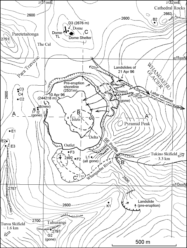 |
Figure 21. Topographic map of Ruapehu's Crater Lake and vicinity showing landslides and associated scarps (arrows and hachured lines) in addition to lahars, lake shore lines and the three profiles on figure 22. Courtesy of IGNS. |
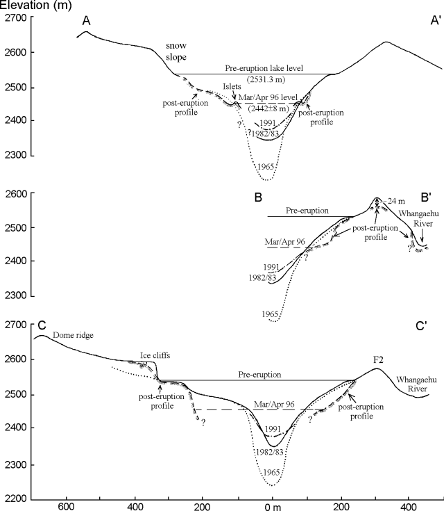 |
Figure 22. Topographic profiles of Ruapehu's crater for areas shown on figure 21. The most recent profiles were constructed from photos taken on 10 April 1996; at that time the bathymetry of the new lake was still unknown and the islets' composition was ambiguous. Courtesy of IGNS. |
The suspected extrusion was first noted as a 6 x 4 m islet within Crater Lake on 21 March photos. Clear weather and a lack of steam on 10 April allowed better photographs. These pictures revealed two new, even smaller islets nearby and another larger one, interpreted as landslide debris, on the opposite side of the lake (profile A-A', figure 22). As of early May, the make-up of these islets remained ambiguous.
The 10 April photo opportunity enabled workers to plot three profiles across the crater (figures 21 and 22). The profiles show the surface of Crater Lake as well as the surrounding crater walls. These profiles were used to make preliminary estimates of the refilling rate for Crater Lake. By assuming similar factors to the 1945-50 interval the lake may completely refill in about 4 years. Post-eruption morphological changes included those on the crater floor and a roughly 24-m drop at the SE crater rim (profile B-B').
After heavy rains and landslides a large secondary lahar was triggered on the NE flank, down the Wahangaehu Glacier and River, about mid-day on 21 April (figure 21). Within the crater, mass wasting raised the lake by ~5 m, covering the islets. About 10 minutes before the lahar was seen at Tukino a M 2.0 seismic signal came from the summit that was unlike any in the past several years. It lasted for ~4 minutes and consisted of two main phases followed by a long coda. This signal was termed a landslide earthquake after researchers concluded that it came from the landslide that generated the lahar.
Figure 21 shows the scarps and landslide paths in the immediate vicinity of the crater, the largest on the NE crater wall was ~40-50 m wide. On the NE, directly outside the crater and immediately E of where station J had been, one failure was ~30-m wide. The material involved in the latter failure consisted mainly of 1995 ejecta. It went well beyond the area shown on figure 21, traveling down the Whangaehu Glacier along a well-developed lahar-cut channel. It then flowed down over the glacier surface, by-passing a sub-glacial tunnel carved by earlier lahars. The lahar entered the Whangaehu River at the glacier's toe. Another landslide on the SE sector (figure 21) apparently began prior to the 1995 eruption but became active again in late February 1995.
Reference. Ruapehu Surveillance Group, 1996, Volcanic eruption at a New Zealand ski resort prompts reevaluation of hazards: Eos, Transactions, American Geophysical Union, v. 77, no. 20, 14 May 1996, p. 189-191.
Geological Summary. Ruapehu, one of New Zealand's most active volcanoes, is a complex stratovolcano constructed during at least four cone-building episodes dating back to about 200,000 years ago. The dominantly andesitic 110 km3 volcanic massif is elongated in a NNE-SSW direction and surrounded by another 100 km3 ring plain of volcaniclastic debris, including the NW-flank Murimoto debris-avalanche deposit. A series of subplinian eruptions took place between about 22,600 and 10,000 years ago, but pyroclastic flows have been infrequent. The broad summait area and flank contain at least six vents active during the Holocene. Frequent mild-to-moderate explosive eruptions have been recorded from the Te Wai a-Moe (Crater Lake) vent, and tephra characteristics suggest that the crater lake may have formed as recently as 3,000 years ago. Lahars resulting from phreatic eruptions at the summit crater lake are a hazard to a ski area on the upper flanks and lower river valleys.
Information Contacts: P.M. Otway, S. Sherburn, and I.A. Nairn Institute of Geological & Nuclear Sciences (IGNS), Private Bag 2000, Wairakei, New Zealand