Report on Telica (Nicaragua) — April 1996
Bulletin of the Global Volcanism Network, vol. 21, no. 4 (April 1996)
Managing Editor: Richard Wunderman.
Telica (Nicaragua) Low-level degassing and sulfur deposits observed in crater
Please cite this report as:
Global Volcanism Program, 1996. Report on Telica (Nicaragua) (Wunderman, R., ed.). Bulletin of the Global Volcanism Network, 21:4. Smithsonian Institution. https://doi.org/10.5479/si.GVP.BGVN199604-344040
Telica
Nicaragua
12.606°N, 86.84°W; summit elev. 1036 m
All times are local (unless otherwise noted)
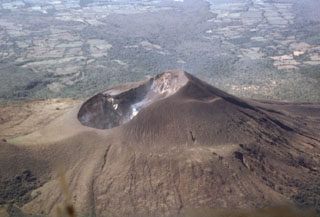
Telica was visited on 17 March by a joint team from the Open University, the Universite de Montreal, Reading University, and the Instituto Nicaraguense de Estudios Territoriales (INETER). Low-temperature sulfur deposits were noted in many places within the crater. Low-level degassing was observed, particularly on the W side of the crater. Sulfur-rich gases appeared to be concentrated at the bottom, while more H2O-rich gases were being emitted at higher levels in the crater. Gas pressures were generally low, but there was a distinct gas column. SO2 flux measured by COSPEC on 17 March averaged 41 ± 20 t/d, based on nine measurements. Microgravity measurements showed no appreciable changes since the last survey in 1994.
An eruption on 31 July 1994 produced a gas-and-ash column to ~800 m above the summit; detectable ash fell as far as 17 km from the summit (BGVN 19:07). Phreatic explosions continued until 12 August 1994 when seismicity began decreasing (BGVN 19:09).
Geological Summary. Telica, one of Nicaragua's most active volcanoes, has erupted frequently since the beginning of the Spanish era. This volcano group consists of several interlocking cones and vents with a general NW alignment. Sixteenth-century eruptions were reported at symmetrical Santa Clara volcano at the SW end of the group. However, its eroded and breached crater has been covered by forests throughout historical time, and these eruptions may have originated from Telica, whose upper slopes in contrast are unvegetated. The steep-sided cone of Telica is truncated by a 700-m-wide double crater; the southern crater, the source of recent eruptions, is 120 m deep. El Liston, immediately E, has several nested craters. The fumaroles and boiling mudpots of Hervideros de San Jacinto, SE of Telica, form a prominent geothermal area frequented by tourists, and geothermal exploration has occurred nearby.
Information Contacts: Hazel Rymer and Mark Davies, Department of Earth Sciences, The Open University, Milton Keynes MK7 6AA, United Kingdom; John Stix, Dora Knez, Glyn Williams-Jones, and Alexandre Beaulieu, Departement de Geologie, Universite de Montreal, Montreal, Quebec H3C 3J7, Canada; Nicki Stevens, Department of Geography, University of Reading, Reading RG2 2AB, United Kingdom; Martha Navarro and Pedro Perez, INETER, Apartado Postal 2110, Managua, Nicaragua.

