Report on Ruapehu (New Zealand) — May 1996

Bulletin of the Global Volcanism Network, vol. 21, no. 5 (May 1996)
Managing Editor: Richard Wunderman.
Ruapehu (New Zealand) Eruption on 17 June sends ash several kilometers above the summit
Please cite this report as:
Global Volcanism Program, 1996. Report on Ruapehu (New Zealand) (Wunderman, R., ed.). Bulletin of the Global Volcanism Network, 21:5. Smithsonian Institution. https://doi.org/10.5479/si.GVP.BGVN199605-241100
Ruapehu
New Zealand
39.28°S, 175.57°E; summit elev. 2797 m
All times are local (unless otherwise noted)
Between approximately 1430 on 15 June and 0100 on 16 June, volcanic tremor reached the highest levels recorded during the previous six months. There were no reports of volcanic activity accompanying this tremor episode; however, poor weather conditions prevented observations after the start of the tremor. At about 0600 on 17 June the level of volcanic tremor started to increase again. The first of several eruption plumes was seen around 0650; larger pulses were observed at 0710 and 0825. The plumes rose several kilometers, carrying voluminous amounts of coarse ash. Large blocks rising to heights of 400-500 m fell as far as 600-700 m from the vent. The second pulse was accompanied by a small lahar down the [E]-flank Whangaehu River valley (see map in BGVN 21:04). Ashfall was recorded as far N as Turangi, 32 km away, due to the prevailing southerly wind. The Alert Level was raised to 3, indicating a significant local eruption in progress (see BGVN 20:09).
Volcanic tremor continued to increase until about 1100 when it plateaued at levels similar to those during the 11-12 October 1995 eruptions. By about 1330 the level of tremor was starting to decline, and the style of activity changed to discrete explosive events. Around 1500 the volcano started to erupt every 10-15 minutes, sending ash-laden plumes to several kilometers height (figure 23). During an overflight around the same time, observers confirmed a small lahar down the Whangaehu catchment but no evidence for pyroclastic flows out of the summit crater basin. Light ashfalls occurred over much of the zone extending N from the volcano to the Bay of Plenty between the coastal towns of Tauranga and Whakatane. A significant Strombolian eruption during 2100-2200 on 17 June was characterized by loud detonations and sprays of glowing rocks ejected above the crater, and was accompanied by strong seismicity. Through to about 0300 several discrete eruption earthquakes were recorded, but the size and rate decreased through the morning of 18 June.
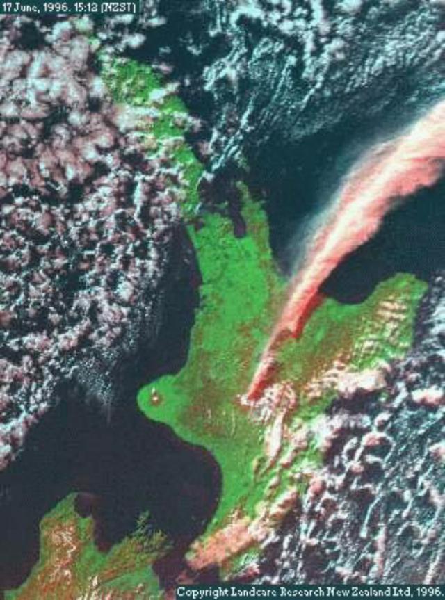 |
Figure 23. Satellite image of the Ruapehu eruption plume, 1512 on 17 June 1996. The ash cloud is rising to about 20 km altitude in clear weather over North Island, New Zealand. The image was created from NOAA-14 data by combining the visible, near infrared, and one thermal infrared wavelength band. Courtesy of Manaaki Whenua Landcare Research. |
Observations made on overflights the morning of 18 June confirmed that the new lake was destroyed and the crater floor was dry. The active vent was in the S part of the crater floor, on which thick deposits of bombs and lapilli had accumulated. The bombs and blocks ejected during the night traveled farther than those erupted on 17 June, to ~1.5 km from the vent. Dome Shelter remained intact, as did the seismic signal from the shelter. On 18 June the active vent was producing weakly ash-charged plumes 1,000-2,000 m above the summit, which were blown downwind, forming a low-level haze at 1,500-3,000 m altitude.
Low-frequency volcanic tremor remained elevated, suggesting that molten material continued to move into the base of the volcano. This eruption was continuing at press time in late June, and had caused significant closures of airspace around the Auckland airport and all of North Island. Additional details will be reported next month.
Geological Summary. Ruapehu, one of New Zealand's most active volcanoes, is a complex stratovolcano constructed during at least four cone-building episodes dating back to about 200,000 years ago. The dominantly andesitic 110 km3 volcanic massif is elongated in a NNE-SSW direction and surrounded by another 100 km3 ring plain of volcaniclastic debris, including the NW-flank Murimoto debris-avalanche deposit. A series of subplinian eruptions took place between about 22,600 and 10,000 years ago, but pyroclastic flows have been infrequent. The broad summait area and flank contain at least six vents active during the Holocene. Frequent mild-to-moderate explosive eruptions have been recorded from the Te Wai a-Moe (Crater Lake) vent, and tephra characteristics suggest that the crater lake may have formed as recently as 3,000 years ago. Lahars resulting from phreatic eruptions at the summit crater lake are a hazard to a ski area on the upper flanks and lower river valleys.
Information Contacts: B.J. Scott, Institute of Geological & Nuclear Sciences (IGNS), Private Bag 2000, Wairakei, New Zealand; Manaaki Whenua Landcare Research Ltd., P.O. Box 38491, Wellington, New Zealand (URL: https://www.landcareresearch.co.nz/).