Report on Suwanosejima (Japan) — June 1996
Bulletin of the Global Volcanism Network, vol. 21, no. 6 (June 1996)
Managing Editor: Richard Wunderman.
Suwanosejima (Japan) Strong eruptions produce volcanic ash clouds
Please cite this report as:
Global Volcanism Program, 1996. Report on Suwanosejima (Japan) (Wunderman, R., ed.). Bulletin of the Global Volcanism Network, 21:6. Smithsonian Institution. https://doi.org/10.5479/si.GVP.BGVN199606-282030
Suwanosejima
Japan
29.638°N, 129.714°E; summit elev. 796 m
All times are local (unless otherwise noted)
On 2 June, an aviation notice to airmen (NOTAM) indicated a volcanic ash cloud to 4,600 m emanating from Suwanose-jima. A second NOTAM at 1515 on 2 June noted that the ash cloud top was at 2,100 m. No discernible ash plume was evident in GMS satellite data from the Japanese Meteorological Agency (JMA) through 1732 on 2 June.
The Kagoshima Prefectural Government confirmed to JMA that emissions on 1-2 June caused ashfall. Ashfall was also observed on the island on 4 June.
The Sakura-jima Volcanological Observatory of Kyushu University reported that activity has continued at the same level since 1994, with nearly constant A-type earthquakes. Ash emissions have occurred this year on 10-13 January, 23 February, 5-6 March, and 14 April. The eruption column in March rose 500 m above the volcano.
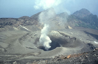
Geological Summary. The 8-km-long island of Suwanosejima in the northern Ryukyu Islands consists of an andesitic stratovolcano with two active summit craters. The summit is truncated by a large breached crater extending to the sea on the E flank that was formed by edifice collapse. One of Japan's most frequently active volcanoes, it was in a state of intermittent Strombolian activity from Otake, the NE summit crater, between 1949 and 1996, after which periods of inactivity lengthened. The largest recorded eruption took place in 1813-14, when thick scoria deposits covered residential areas, and the SW crater produced two lava flows that reached the western coast. At the end of the eruption the summit of Otake collapsed, forming a large debris avalanche and creating an open collapse scarp extending to the eastern coast. The island remained uninhabited for about 70 years after the 1813-1814 eruption. Lava flows reached the eastern coast of the island in 1884. Only about 50 people live on the island.
Information Contacts: Volcano Research Center, Earthquake Research Institute, University of Tokyo, Yayoi 1-1-1, Bunkyo-ku, Tokyo 113, Japan (URL: http://www.eri.u-tokyo.ac.jp/VRC/index_E.html); Jim Lynch, NOAA/NESDIS Synoptic Analysis Branch (SAB), Room 401, 5200 Auth Road, Camp Springs, MD 20746, USA; Volcanological Division, Japan Meteorological Agency, 1-3-4 Ote-machi, Chiyoda-ku, Tokyo 100, Japan.