Report on Atka Volcanic Complex (United States) — June 1996
Bulletin of the Global Volcanism Network, vol. 21, no. 6 (June 1996)
Managing Editor: Richard Wunderman.
Atka Volcanic Complex (United States) Eruption of volcanic ash
Please cite this report as:
Global Volcanism Program, 1996. Report on Atka Volcanic Complex (United States) (Wunderman, R., ed.). Bulletin of the Global Volcanism Network, 21:6. Smithsonian Institution. https://doi.org/10.5479/si.GVP.BGVN199606-311160
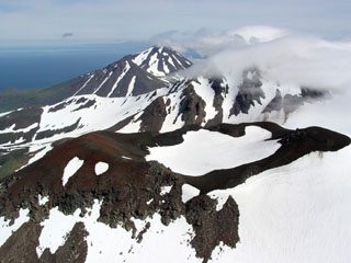
Atka Volcanic Complex
United States
52.331°N, 174.139°W; summit elev. 1518 m
All times are local (unless otherwise noted)
On 29 June, Japan Airlines reported volcanic ash erupting from Atka. In addition, GEOS-9 satellite images showed a possible small ash cloud in the immediate vicinity of Atka. In early May 1995 residents of Atka village observed a small plume-like cloud over Kliuchef and reported a strong sulfur smell (BGVN 20:05).
[The 1996 eruption described here was later discredited.]
Geological Summary. The Atka Volcanic Complex consists of a central shield and Pleistocene caldera and four notable volcanic cones. A major explosive dacitic eruption accompanied formation of the caldera about 500,000 to 300,000 years ago; approximately half of the caldera rime remains, open towards the NW. The Sarichef cone, ~5 km ESE of the caldera rim, retains a symmetrical profile, unlike most other heavily eroded features outside the caldera to the S and W. The Kliuchef stratovolcano grew within the caldera and exhibits five eruptive vents striking NE, including two at the summit, that have been active in the Holocene. A 700-m-diameter crater 1 km NE of the summit may have been the source vent for a large 1812 CE eruption. Hot springs and fumaroles are located on the flanks of Kliuchef and in a glacial valley to the SW. The most frequently active volcano of the complex is Korovin, at the NE tip of Atka Island about 5 km N of Kliuchef. An 800-m-diameter crater on the SE side of the summit contains a deep circular pit that sometimes contains a crater lake thought to be the source of phreatic ash explosions. The smaller Konia cone, slightly offset to the E, lies between Kliuchef and Korovin. Most of the lava flows in the complex are basaltic, though some dacitic flows are also present.
Information Contacts: Alaska Volcano Observatory (AVO), a cooperative program of a) U.S. Geological Survey, 4200 University Drive, Anchorage, AK 99508-4667, USA, b) Geophysical Institute, University of Alaska, PO Box 757320, Fairbanks, AK 99775-7320, USA, and c) Alaska Division of Geological & Geophysical Surveys; NOAA/NESDIS Synoptic Analysis Branch (SAB), Room 401, 5200 Auth Road, Camp Springs, MD 20746, USA.