Report on St. Helens (United States) — June 1996

Bulletin of the Global Volcanism Network, vol. 21, no. 6 (June 1996)
Managing Editor: Richard Wunderman.
St. Helens (United States) Dwindling seismicity
Please cite this report as:
Global Volcanism Program, 1996. Report on St. Helens (United States) (Wunderman, R., ed.). Bulletin of the Global Volcanism Network, 21:6. Smithsonian Institution. https://doi.org/10.5479/si.GVP.BGVN199606-321050
St. Helens
United States
46.2°N, 122.18°W; summit elev. 2549 m
All times are local (unless otherwise noted)
No eruptive activity occurred during the first half of 1996, and a trend of declining seismicity since October 1995 continued. Thus far in 1996 monthly earthquake totals have been: January, 14; February, 13; March, 17; April, 16; May, 11; and June, 10 (figure 11). At 1651 on 21 February, an M 2.4 earthquake occurred ~4 km beneath the crater floor; this was followed by four locatable aftershocks and then by ~20 very small seismic events that resembled signals typical of rock or snow avalanches. These later events were shallow, apparently triggered by the M 2.4 earthquake that preceded them. Activity returned to normal within a few hours. Except for that on 21 February, the rest of the earthquakes from January to June did not exceed M 2.0. During the night of 9 June, a large seismic event from the volcano triggered an automated, 24-hour alarm system. The character of the signal suggested that the source was a rockfall from the crater wall. This interpretation was confirmed when a USGS crew working in the crater on 11 June observed a large fresh rockfall deposit that originated from the S crater wall. Rockfalls are a common occurrence in the crater during the summer, and generally do not indicate any increase in volcanic activity.
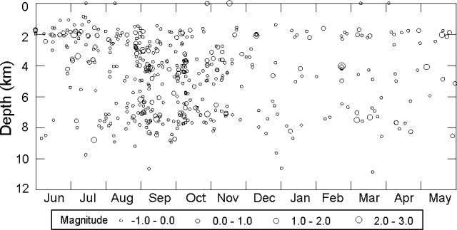 |
Figure 45. Plot of focal depth versus time for earthquakes at Mount St. Helens, July 1995-June 1996. Courtesy of the Cascades Volcano Observatory, U.S. Geological Survey. |
Geological Summary. Prior to 1980, Mount St. Helens was a conical volcano sometimes known as the Fujisan of America. During the 1980 eruption the upper 400 m of the summit was removed by slope failure, leaving a 2 x 3.5 km breached crater now partially filled by a lava dome. There have been nine major eruptive periods beginning about 40-50,000 years ago, and it has been the most active volcano in the Cascade Range during the Holocene. Prior to 2,200 years ago, tephra, lava domes, and pyroclastic flows were erupted, forming the older edifice, but few lava flows extended beyond the base of the volcano. The modern edifice consists of basaltic as well as andesitic and dacitic products from summit and flank vents. Eruptions in the 19th century originated from the Goat Rocks area on the N flank, and were witnessed by early settlers.
Information Contacts: Dan Dzurisin, Cascades Volcano Observatory, U.S. Geological Survey, 5400 MacArthur Blvd., Vancouver, WA 98661 USA (URL: http://volcanoes.usgs.gov/); Steve Malone, Geophysics Program, University of Washington, Seattle, WA 98195 USA (URL: https://volcanoes.usgs.gov/observatories/cvo/).