Report on Kama'ehuakanaloa (United States) — July 1996
Bulletin of the Global Volcanism Network, vol. 21, no. 7 (July 1996)
Managing Editor: Richard Wunderman.
Kama'ehuakanaloa (United States) Earthquake swarm and a new submarine pit crater
Please cite this report as:
Global Volcanism Program, 1996. Report on Kama'ehuakanaloa (United States) (Wunderman, R., ed.). Bulletin of the Global Volcanism Network, 21:7. Smithsonian Institution. https://doi.org/10.5479/si.GVP.BGVN199607-332000
Kama'ehuakanaloa
United States
18.92°N, 155.27°W; summit elev. -975 m
All times are local (unless otherwise noted)
The largest swarm of earthquakes ever recorded on the Hawaiian volcanoes occurred below Lōʻihi seamount in July-August (figures 7 and 8). The seismic network maintained by the Hawaiian Volcano Observatory (HVO) began detecting events from this swarm at 2154 on 16 July; events continued at low rates until 20 July, when counts rapidly increased. More than 4,000 earthquakes were recorded through 29 July. Several hundred of M >= 3.0 were detected, and more than 80 were M >= 4. The largest event, M 5.0, occurred at 2330 on 27 July. The number of events decreased in early August.
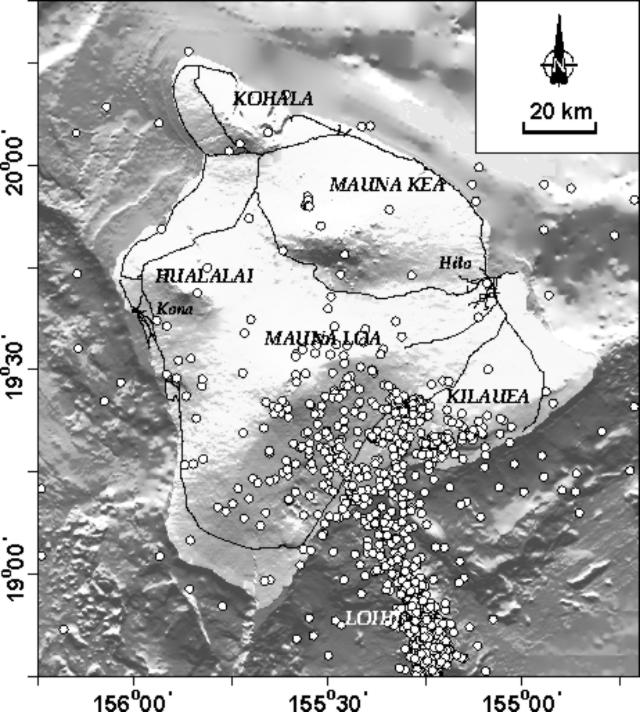 |
Figure 7. Distribution of Hawaiian earthquakes during 12- 25 July. Courtesy of HVO. |
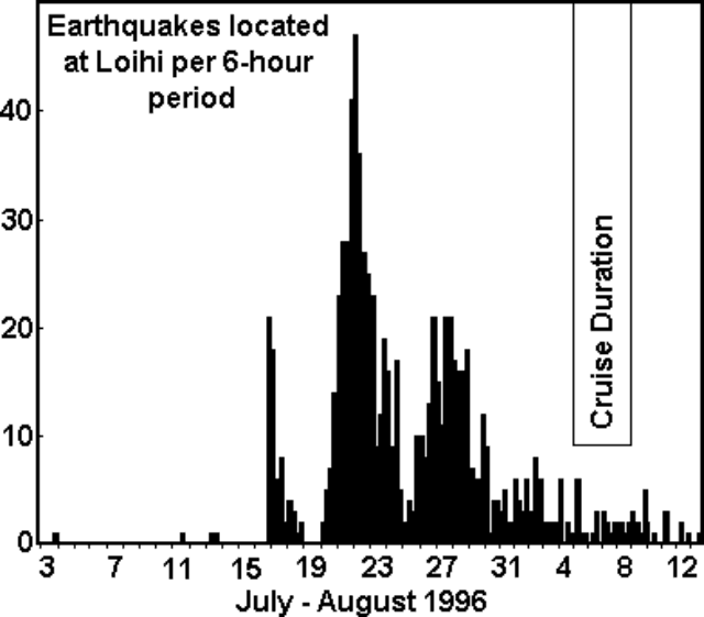 |
Figure 8. Histogram of the Lōʻihi earthquakes, 3 July-13 August 1996. Each vertical bar represents a 6-hour time period. Courtesy of the Hawaii Center for Volcanology. |
In an effort sponsored by the U.S. National Science Foundation, an interdisciplinary team of researchers from the University of Hawaii, in collaboration with scientists from the U.S. Geological Survey, the Bishop Museum, and the University of Washington, investigated this unique event. The team left Honolulu at 0700 on 5 August and returned on the evening of 10 August after a six-day observation by the research ship and manned submersible. The following summary is from the daily reports of the Hawaii Center for Volcanology.
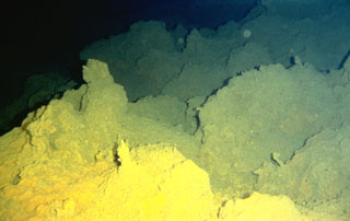
6 August. Amidst ongoing intense seismic and inferred volcanic activity, scientists were rocked by several earthquakes felt through the hull of the research vessel Kaimikai O Kanaloa (RV KOK) as they steamed over Lōʻihi. On their first pass over the volcano, they noted that Pele's Vents, an area 980 m below the surface where active hydrothermal venting had been recorded by previous cruises, was no longer there. The area was now the site of a pit crater 260 m in diameter and 300 m deep (named "Pele's Puka"), roughly the same size as similar craters at Kīlauea. Water samples recovered from the area near Pele's Puka were 2.5°C warmer than the surrounding water and highly acidic, indicating that they were nearly saturated in carbon dioxide. The water samples were milky brown in color because of suspended fine particles of what is probably volcanic glass. These characteristics, along with other chemical indicators, imply that the samples were taken very close to an underwater volcanic eruption.
7 August. Scientists raised and lowered instruments in the water, mainly looking for anomalies in water temperature and chemistry and also listening for sounds that might indicate an eruption. Except for the area around the peak of Lōʻihi, the sounds and water appeared normal, but toward the S end of the summit region the water was considerably warmer than usual, charged with carbon dioxide, and loaded with suspended particles. This "plume" of warm water was among the most intense ever recorded in the ocean. Sonobuoys, which broadcast sounds back to the ship by radio from underwater microphones, picked up crackling and grinding noises in the summit area, which could have been sounds of an eruption in progress.
8 August. Scientists in the PISCES V manned submersible landed near the highest point of the seamount (PISCES Peak) and worked their way slowly toward the new pit crater through murky waters, with visibility
Geological Summary. The Kama’ehuakanaloa seamount, previously known as Loihi, lies about 35 km off the SE coast of the island of Hawaii. This youngest volcano of the Hawaiian chain has an elongated morphology dominated by two curving rift zones extending north and south of the summit. The summit region contains a caldera about 3 x 4 km and exhibits numerous lava cones, the highest of which is about 975 m below the ocean surface. The summit platform also includes two well-defined pit craters, sediment-free glassy lava, and low-temperature hydrothermal venting. An arcuate chain of small cones on the western edge of the summit extends north and south of the pit craters and merges into the crests prominent rift zones. Seismicity indicates a magmatic system distinct from that of Kilauea. During 1996 a new pit crater formed at the summit, and lava flows were erupted. Continued volcanism is expected to eventually build a new island; time estimates for the summit to reach the ocean surface range from roughly 10,000 to 100,000 years.
Information Contacts: Hawaii Center for Volcanology, Department of Geology & Geophysics, University of Hawaii at Manoa, 2525 Correa Road, Honolulu, HI 96822 USA (URL: http://www.soest.hawaii.edu/GG/hcv.html); Hawaiian Volcano Observatory (HVO), U.S. Geological Survey, PO Box 51, Hawaii National Park, HI 96718, USA (URL: http://www.soest.hawaii.edu/hvo/).