Report on Ubinas (Peru) — July 1996

Bulletin of the Global Volcanism Network, vol. 21, no. 7 (July 1996)
Managing Editor: Richard Wunderman.
Ubinas (Peru) Increased fumarolic activity prompts seismic and other monitoring
Please cite this report as:
Global Volcanism Program, 1996. Report on Ubinas (Peru) (Wunderman, R., ed.). Bulletin of the Global Volcanism Network, 21:7. Smithsonian Institution. https://doi.org/10.5479/si.GVP.BGVN199607-354020
Ubinas
Peru
16.345°S, 70.8972°W; summit elev. 5608 m
All times are local (unless otherwise noted)
Ubinas stratovolcano (figure 1) is known for persistent weak fumarolic activity; this appeared to increase after December 1995 and was vigorous during April 1996. During April five steam vents were located along a ~N40°W-trending fault cutting across the crater's floor and walls. White steam from the fumaroles commonly rose 100-500 m above the crater and occasionally rose 1-1.5 km above the caldera rim. Seismic monitoring during April detected ~50-70 events/day, a suggestion of increased seismicity.
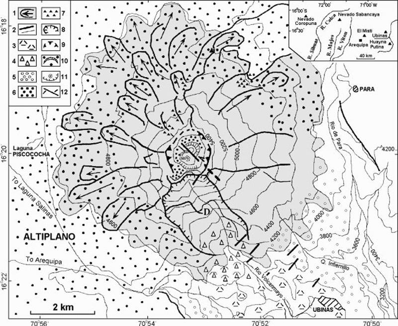 |
Figure 1. Geologic and topographic map of the Ubinas stratovolcano (regional location shown on inset). Symbols in key are as follows: 1) Ubinas volcano, mainly constructed of Pleistocene andesite lava flows; 2) lava flow cliffs >200 m high and scarps of glaciated lava flows; 3) "old" debris-avalanche deposits; 4) hummocks of recent debris-avalanche deposits; 5) Plinian fallout deposits related to the summit-caldera-forming eruption of Late-glacial age; 6) tephra-fall deposits from the 1600 AD eruption of Huaynaputina volcano; 7) channeled scoria-flow deposits; 8) headwall of caldera or rockslide avalanche; 9) summit caldera; 10) youthful ash cone and ashfall deposits mantling the caldera floor; 11) pit crater and >500-m-high walls cut in hydrothermally altered lava flows; 12) ~N40°W trending strike-slip fault and N45°E trending fractures; and D) lava dome. Drafted by F. Amathe and provided courtesy of J-C. Thouret. |
These observations led to designation of the hazard level as "Yellow," and this information was sent to local civil authorities. Scientists installed seismic instruments (three digital PDR-1 Kinemetrics and one visual MEQ-600) on the volcano's W, N, and SE flanks at ~4,800 m elevation.
Continued field work was aimed at assessing hazards and outlining preliminary hazard-zone maps. Potential hazards include debris avalanches, Plinian tephra, phreatic outbursts, and pyroclastic flows and lahars. Debris-avalanche deposits crop out in the Rio Ubinas as far as 10 km downstream. Future debris avalanches could occur if the caldera headwall, which is only 120-400 m thick, failed due to dome extrusion or seismic loading.
Widespread Plinian pumice-fall deposits include some of Holocene age. The eruption that formed the summit caldera left a conspicuous 3-m-thick Plinian tephra chiefly distributed towards the SSE, in the direction of the village of Ubinas (6 km from the vent). At least three Ubinas tephra-fall layers postdate the 1600 AD eruption of Huaynaputina (a center located 25 km S, figure 1). In contrast to the Plinian fall deposits, the intra-caldera deposits are nearly all ash and lapilli fallout of phreatomagmatic and phreatic origin.
Snowfields on the S-facing summit area above 5,000 m elevation remain during December through July and thus could be melted to generate S- and SE-flank debris flows. Pyroclastic flows could follow the same routes. Recent scoria-flow deposits remaining on the steep NW and N flanks suggest that pyroclastic flows may spill over the lower breaches of the caldera rim and down these slopes.
A 27 June news report in the Lima paper El Comercio briefly mentioned ongoing deformation and seismic studies; it included a panoramic view of the summit's nested craters with the inner pit crater emitting steam. The article also pointed out that the district of Ubinas has ~5,000 inhabitants.
Ubinas (also known as Uvinas and Uvillas) is Perú's most active volcano. Holocene lava flows cover its flanks, but the historical record, which extends back to the mid-1500's, contains evidence of minor explosive eruptions. Ubinas rises about 1,300 m above the altiplano of the Cordillera Occidental. Its summit crater is 200-400 m deep, ~1.5 km in diameter, and hosts a smaller inner crater.
Geological Summary. The truncated appearance of Ubinas, Perú's most active volcano, is a result of a 1.4-km-wide crater at the summit. It is the northernmost of three young volcanoes located along a regional structural lineament about 50 km behind the main volcanic front. The growth and destruction of Ubinas I was followed by construction of Ubinas II beginning in the mid-Pleistocene. The upper slopes of the andesitic-to-rhyolitic Ubinas II stratovolcano are composed primarily of andesitic and trachyandesitic lava flows and steepen to nearly 45°. The steep-walled, 150-m-deep summit crater contains an ash cone with a 500-m-wide funnel-shaped vent that is 200 m deep. Debris-avalanche deposits from the collapse of the SE flank about 3,700 years ago extend 10 km from the volcano. Widespread Plinian pumice-fall deposits include one from about 1,000 years ago. Holocene lava flows are visible on the flanks, but activity documented since the 16th century has consisted of intermittent minor-to-moderate explosive eruptions.
Information Contacts: J-C. Thouret and J-L. Le Pennec, ORSTOM (UR14)-Instituto Geofísico del Perú (IGP), Calle Calatrava 216, Urbinizacion Camino Real, La Molina, Lima 100, Perú; R. Woodman, IGP Lima, and O. Macedo, IGP Volcano and Geophysics Observatory, Cayma-Arequipa, Perú.