Report on Soufriere Hills (United Kingdom) — August 1996

Bulletin of the Global Volcanism Network, vol. 21, no. 8 (August 1996)
Managing Editor: Richard Wunderman.
Soufriere Hills (United Kingdom) Dome growth continues, activity level increases
Please cite this report as:
Global Volcanism Program, 1996. Report on Soufriere Hills (United Kingdom) (Wunderman, R., ed.). Bulletin of the Global Volcanism Network, 21:8. Smithsonian Institution. https://doi.org/10.5479/si.GVP.BGVN199608-360050
Soufriere Hills
United Kingdom
16.72°N, 62.18°W; summit elev. 915 m
All times are local (unless otherwise noted)
The following condenses daily reports of the Montserrat Volcano Observatory (MVO) for the period 1 August-1 September. Seismicity and other significant events are summarized in tables 11 and 12. In a comment in the journal Nature, Peter Francis (1996) noted how Soufriere Hills' magma appeared depleted in volatiles with a low SO2/HCl ratio.
Though not discussed in this report, the largest and most destructive eruption of the 1-year-old eruption began at 2345 on 17 September. No casualties were reported but towns and villages on the NW side of the volcano were evacuated. The resulting plume covered a substantial part of the Caribbean.
Table 11. Chronology of seismicity and other major events at Soufriere Hills, Montserrat, 1 August through 1 September. The observation period is a 24-hour interval beginning at 1600 the previous day. Courtesy of MVO.
| Date | Volcano-tectonic | Long-period | Hybrid | Rockfall | Tremor Intensity | Visual Observations |
| 01 Aug 1996 | 20 | 36 | 215 | 117 | Low | -- |
| 02 Aug 1996 | 24 | 6 | 250 | 49 | Low-to-high | -- |
| 03 Aug 1996 | 43 | 340 | 58 | -- | Low-to-high | -- |
| 04 Aug 1996 | -- | -- | -- | -- | High | Ash clouds up to 3.3 km; small pyroclastic flows |
| 05 Aug 1996 | 71 | 0 | 373 | 64 | High | Small ash cloud |
| 06 Aug 1996 | 22 | 3 | 556 | 48 | High | Small ash clouds and minor pyroclastic flows |
| 07 Aug 1996 | 36 | 2 | 427 | 32 | High | Small ash cloud |
| 08 Aug 1996 | 47 | 3 | 310 | 47 | High | Small ash clouds rose to 2.3 km; small pyroclastic flows |
| 09 Aug 1996 | 97 | 4 | 147 | 67 | Low-to-high | Ash clouds at 1.3-3.1 km; small pyroclastic flows |
| 10 Aug 1996 | 74 | 0 | 137 | 153 | -- | Ash clouds at 2.6 km; small pyroclastic flows |
| 11 Aug 1996 | 37+ | 0 | 29+ | 182+ | -- | Ash cloud reported between 10-13 km; significant ashfall; intense pyroclastic flow activity |
| 12 Aug 1996 | 7 | 0 | 56 | 82 | Low | Ash cloud reported at 10 km; one large pyroclastic flow and several minor ones |
| 13 Aug 1996 | 0 | 39 | 42 | 117 | Low | Small ash cloud; pyroclastic flows; one flash flood |
| 14 Aug 1996 | 37 | 4 | 31 | 82 | -- | Ash cloud at 3.3 km; pyroclastic flows traveled 100 m to the sea |
| 15 Aug 1996 | 14 | 1 | 14 | 61 | -- | Ash clouds up to 1.6 km; small pyroclastic flows |
| 16 Aug 1996 | 28 | 0 | 34 | 67 | Low | Several small ash clouds and pyroclastic flows; flash floods |
| 17 Aug 1996 | 13 | 0 | 35 | 118 | Low-to-moderate | Ash cloud rose to 2 km; few pyroclastic flows; flash floods |
| 18 Aug 1996 | 5 | 4 | 21 | 70 | Low | Ash cloud up to 2 km; few small flows |
| 19 Aug 1996 | 32 | 1 | 22 | 103 | Low | Ash clouds to 3.3 km; some pyroclastic flows |
| 20 Aug 1996 | 30 | 1 | 33 | 161 | -- | Ash clouds at 1.6-4 km; small pyroclastic flows |
| 21 Aug 1996 | 1 | 2 | 36 | 131 | Low | Ash clouds at 5 km; significant ashfall; near continuous pyroclastic flows |
| 22 Aug 1996 | 20 | 1 | 34 | 118 | Low | Ash cloud at 2.6 km; two large pyroclastic flows reached the new delta |
| 23 Aug 1996 | 0 | 0 | 7 | 51 | Low | Small ash clouds and ashfalls |
| 24 Aug 1996 | 2 | 0 | 1 | 26 | Low-to-moderate | Ash at 1.6 km |
| 25 Aug 1996 | 3 | 0 | 0 | 62 | Low-to-Moderate | One very small ash cloud |
| 26 Aug 1996 | 17 | 0 | 8 | 82 | Low | Some very small ash clouds |
| 27 Aug 1996 | 30 | 10 | 7 | 115 | Low | Small ash clouds; one small pyroclastic flow |
| 28 Aug 1996 | 0 | 8 | 12 | 49 | Low | Small ash cloud |
| 29 Aug 1996 | -- | several | -- | -- | -- | -- |
| 30 Aug 1996 | 146 | 2 | 24 | 55 | Low | Ash cloud rose to 1.1 km |
| 31 Aug 1996 | -- | several | -- | -- | -- | -- |
| 01 Sep 1996 | 107 | 21 | 4 | 92 | Low | Ash clouds |
Overview. Activity in August continued at a higher level than last month (BGVN 21:07) but small- to moderate-sized rockfalls and small pyroclastic flows continued to be restricted to the Tar River Valley on the E flanks of the growing lava dome. Occasionally the flows traveled as far as the sea, building a new delta that extended 400 m offshore (figure 9). Daily emissions resulted in variable ashfalls to the WNW.
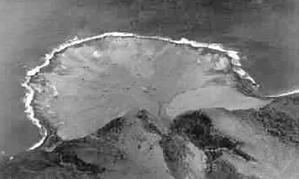 |
Figure 9. The new delta created by the pyroclastic flows of late July down the Tar River Valley. By 4 August the delta had extended 400 m into the sea and was ~550 m wide at its base. Courtesy of Glenn Lewis. |
Seismicity included larger numbers of hybrid earthquakes compared to July and the occurrence of volcano-tectonic earthquakes in swarms at depths of <2 km beneath English's Crater. Ash-rich steam frequently escaped from a collapse structure on the upper dome. These emissions were vigorous and associated with intermittent low-amplitude tremor, suggesting magma-groundwater interaction.
Significant ashfalls occurred in Plymouth, Richmond Hill, and Fox's Bay. Lighter ashfalls were reported from St. George's Hill, Cork Hill, and Garibaldi Hill. The ash fall of 12 August had the following measured thicknesses: 2 cm in Lovers Lane, 3 cm at Plymouth Police Headquarters, 6 mm in Trials, 2 mm in Gingoes, 19 mm on Fort Ghaut bridge, 3 mm in Fox's Bay, and 2 mm in Weekes.
The highest point on the dome was measured from Chance's Peak on 16 August and yielded an elevation of ~963 m. On 17 August, good visibility showed that the E part of the dome was very unstable and the observed rockfalls generally originated from this area. Within the crater, an eroded gully N of Castle Peak channeled debris from the E dome down the upper reaches of the Tar River valley, almost filling it. On 19 August a large pyroclastic flow reached the new delta but did not enter the sea. On 21 August another flow traveled a distance of ~1.5 km and produced an ash cloud that reached a maximum altitude of ~4.6 km. Near-continuous rockfalls resulted in several ash clouds that caused significant ashfalls in Plymouth and surroundings.
Good visibility on 22 August allowed scientists to conclude that the most recent pyroclastic flows were produced by the loss of material from the lower section of the new dome grown in the collapse structure produced by events of 29 and 31 July 1996. At this time the gully N of Castle Peak was almost empty.
Activity during 23 August-1 September.On 23 August the lowest activity of the month occurred, after which activity remained at a level lower than the previous three weeks. Reports during this interval mentioned small- to moderate-sized rockfalls, very few small pyroclastic flows, ash columns below 1.5 km, and an occasional sprinkling of ash on some central and N areas. On 26 August observers noted that the gully just N of Castle Peak was again filled with debris. On 30 August, brief glimpses of the dome from Bramble Airport Control Tower suggested that two extruded features (possibly spines) existed in the central part of the E dome. Light ash clouds associated with some larger rockfalls and/or small pyroclastic flows were occasionally seen drifting SSE at 1.1 km above sea level. On 1 September the runout of rockfalls and small pyroclastic flows along Tar Valley was generally <1 km.
At the end of the month an increase in volcano-tectonic earthquakes was interpreted as the continuous movement of magma from shallow depths to the surface as the process of dome growth continued.
EDM and COSPEC measurements. EDM measurements (table 12) showed a continuous, though somewhat variable shortening trend. This was especially prominent on the E triangle (Whites-Castle Peak-Long Ground). COSPEC measurements of SO2 in the volcanic plume gave the following results: 8 August, ~326 metric tons/day (t/d); 12 August, 1, 195 t/d; 13 August, 626 t/d; and 24 August, 258 t/d.
Table 12. EDM data from Soufriere Hills, Montserrat, 1 August through 1 September 1996. Courtesy of MVO.
| Date | Shortening (-) or lengthening (+)/day(s) | Line or triangle |
| 01 Aug 1996 | -4 mm | Whites-Castle Peak |
| 02 Aug 1996 | -12 mm/3 days | Whites-Castle Peak-Long Ground |
| 03 Aug 1996 | -2 mm/1 day | Whites-Castle Peak |
| 03 Aug 1996 | -9 mm/1 day | Long Ground-Castle Peak |
| 06 Aug 1996 | -3 mm/2 days | Whites-Castle Peak |
| 06 Aug 1996 | -2 mm/3 days | Long Ground-Castle Peak |
| 07 Aug 1996 | -8 mm/1 day | Whites-Castle Peak |
| 07 Aug 1996 | -8 mm/1 day | Long Ground-Castle Peak |
| 09 Aug 1996 | -25 mm/2 days | Whites-Castle Peak |
| 09 Aug 1996 | -31 mm/2 days | Long Ground-Castle Peak |
| 10 Aug 1996 | -1 mm/1 day | Whites-Castle Peak |
| 10 Aug 1996 | -16 mm/1 day | Long Ground-Castle Peak |
| 12 Aug 1996 | +24 mm/28 days | Amersham-Amersham slope |
| 12 Aug 1996 | -28 mm/28 days | Amersham-Chances Peak |
| 16 Aug 1996 | -11 mm/2 days | Whites-Castle Peak |
| 16 Aug 1996 | 0 | Long Ground-Castle Peak |
| 18 Aug 1996 | +4 mm/2 days | Whites-Castle Peak |
| 18 Aug 1996 | +1 mm/2 days | Long Ground-Castle Peak |
| 19 Aug 1996 | -16 mm/55 days | Galways-Chances Peak |
| 19 Aug 1996 | -12 mm/55 days | Ogarras-Chances Peak |
| 22 Aug 1996 | -16 mm/16 days | Windy Hill-Farrell |
| 23 Aug 1996 | 0 | Amersham-Amersham slope |
| 23 Aug 1996 | +29 mm/11 days | Amersham-Chances Peak |
| 25 Aug 1996 | -14 mm/7 days | Whites-Castle Peak |
| 25 Aug 1996 | -7 mm/7 days | Long Ground-Castle Peak |
| 25 Aug 1996 | -4 mm/6 days | Galways-Chances Peak |
| 25 Aug 1996 | -5 mm/6 days | Ogarras-Chances Peak |
| 26 Aug 1996 | -1 mm/1 day | Whites-Castle Peak |
| 26 Aug 1996 | -1 mm/1 day | Long Ground-Castle Peak |
| 27 Aug 1996 | -14 mm/1 day | Whites-Castle Peak |
| 27 Aug 1996 | -1 mm/1 day | Long Ground-Castle Peak |
Reference. Francis, P., 1996, Volcanoes - danger and dependency: News and Views, Nature, v. 383 (5 Sept.), p. 28.
Geological Summary. The complex, dominantly andesitic Soufrière Hills volcano occupies the southern half of the island of Montserrat. The summit area consists primarily of a series of lava domes emplaced along an ESE-trending zone. The volcano is flanked by Pleistocene complexes to the north and south. English's Crater, a 1-km-wide crater breached widely to the east by edifice collapse, was formed about 2000 years ago as a result of the youngest of several collapse events producing submarine debris-avalanche deposits. Block-and-ash flow and surge deposits associated with dome growth predominate in flank deposits, including those from an eruption that likely preceded the 1632 CE settlement of the island, allowing cultivation on recently devegetated land to near the summit. Non-eruptive seismic swarms occurred at 30-year intervals in the 20th century, but no historical eruptions were recorded until 1995. Long-term small-to-moderate ash eruptions beginning in that year were later accompanied by lava-dome growth and pyroclastic flows that forced evacuation of the southern half of the island and ultimately destroyed the capital city of Plymouth, causing major social and economic disruption.
Information Contacts: Montserrat Volcano Observatory (MVO), c/o Chief Minister's Office, PO Box 292, Plymouth, Montserrat (URL: http://www.mvo.ms/); NOAA/NESDIS Satellite Analysis Branch (SAB), Room 401, 5200 Auth Road, Camp Springs, MD 20746, USA; Susan and Eddie Edgecombe, and Betty Dix, Tradewinds Real Estate, Box 365, Plymouth, Montserrat; Glenn Lewis, c/o Doug, Deb, and Paul Darby, 6 Satinwood Road, Rocky Point, NY 11778 USA.