Report on Ol Doinyo Lengai (Tanzania) — September 1996

Bulletin of the Global Volcanism Network, vol. 21, no. 9 (September 1996)
Managing Editor: Richard Wunderman.
Ol Doinyo Lengai (Tanzania) Crater observations during July-September
Please cite this report as:
Global Volcanism Program, 1996. Report on Ol Doinyo Lengai (Tanzania) (Wunderman, R., ed.). Bulletin of the Global Volcanism Network, 21:9. Smithsonian Institution. https://doi.org/10.5479/si.GVP.BGVN199609-222120
Ol Doinyo Lengai
Tanzania
2.764°S, 35.914°E; summit elev. 2962 m
All times are local (unless otherwise noted)
The following report summarizes morphological changes in the summit crater seen during visits on 16 July, 17 August, and 24 September (figures 42-46). The crater was estimated to be ~400 m in diameter. Emissions of carbonatitic lava have been observed on many visits since July 1995 (BGVN 20:10, 20:11/12, 21:04, and 21:06).
On 16 July Celia Nyamweru and Mark Alvin reported that cone T39 was bubbling and splashing clots of molten lava every 30-60 seconds. The largest splashes reached 1-2 m above the vent. There was a recently formed pahoehoe flow ~50 m long and 2-3 m wide coming from the E side of cone T37. The continuous noise of gas escaping at high pressure was heard from a new vent, T38, between T5T9 and T20. Another new vent, T40, had formed by the N wall of the crater; it had produced a pahoehoe flow that covered a large portion of N and NE crater floor. At the time of the visit the sound of bubbling lava was coming from within this vent. Considerable volumes of steam were escaping from a longitudinal crack trending NW-SE on the W part of the crater floor, and sulfur fumes were escaping from a deep open crack on the E rim.
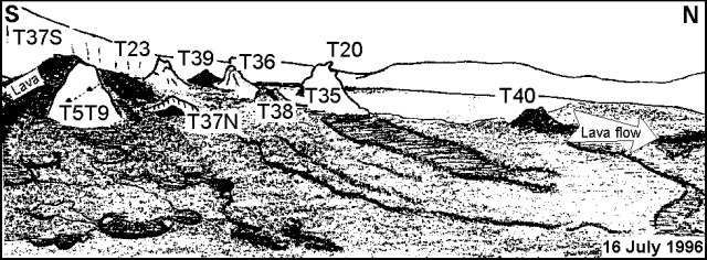 |
Figure 42. Sketch of the Ol Doinyo Lengai crater looking W from the E rim, 16 July 1996. Courtesy of C. Nyamweru. |
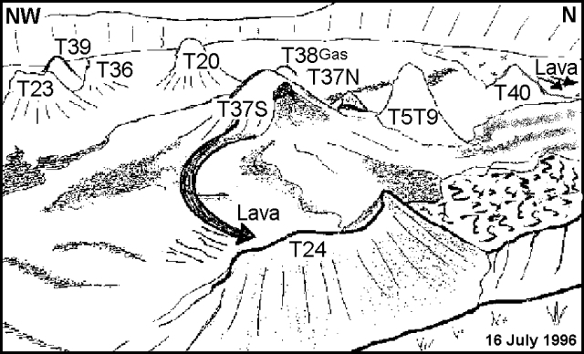 |
Figure 43. Sketch of the Ol Doinyo Lengai crater looking NNW from the SE Rim, 16 July 1996. Courtesy of C. Nyamweru, from a photo by B.A. Gadiye. |
T24 was partially filled with lava from T37S; there was some sulfur staining and steaming emissions on it. T5T9 was also emitting small amounts of steam (figure 44). T37S, now a broad cone with several peaks, was taller than T5T9. It had emitted several pahoehoe flows toward E and between T5T9 and the crater wall, totally covering F35. T37N showed an open pit below an overhanging wall, and T36 had a spine recently formed on its top. T20 appeared white-to-pale brown, with a rounded top and some steam emission. Near its base T35 had almost completely crumbled and collapsed. A small open circular vent (not numbered) at the base of the E wall had covered some of the vegetation on the crater wall with spatters of lava. It was surrounded by an overhang with small lava stalactites. Slight warmth was perceived from the vent but the lava stalactites were white. T15, T8, and T14, buried under recent flows from T40 and T37S, were no longer visible. The crater walls had several vertical cracks on the NW side, the lowest wall, facing E, was ~8 m high.
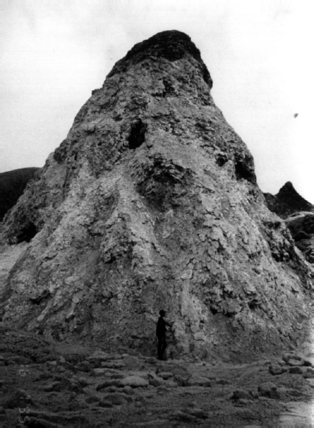 |
Figure 44. Photo of T5T9 in the Ol Doinyo Lengai crater, 16 July 1996. The estimated height of the cone is ~10 m. Estimated crater diameter (left to right) is ~400 m. Courtesy of C. Nyamweru. |
Christoph Weber reported that on 17 August the crater floor had been covered with new black aa and pahoehoe lava flows. Weber had met another traveler, however, who had observed no eruptice activity about 14 days earlier. When Weber visited, he estimated the thickness of the fresh flows as typically ~20-30 cm. Fresh flows were easy to distinguish because they change from black to grayish white as they cool. They were often stacked, particularly on flow field F37, the one most active at that time, forming a composite of new flow material perhaps a meter thick overall. The area covered by these new flows was ~30,000 m2. Thus, in the first half of August, the volume of erupted lava was on the order of 30,000 m3. Because of the rough irregular surfaces on some flows, their contacts with successive flows often contained considerable void space. Many of the flows were tube-fed, the tubes typically being 10- to 150-m long. When Weber left on 17 August lavas still poured out. He also observed a lava fountain ~3-m-high on T37. On 24 September some students from St. Lawrence University observed continuous bubbling and spattering of lavas from several vents.
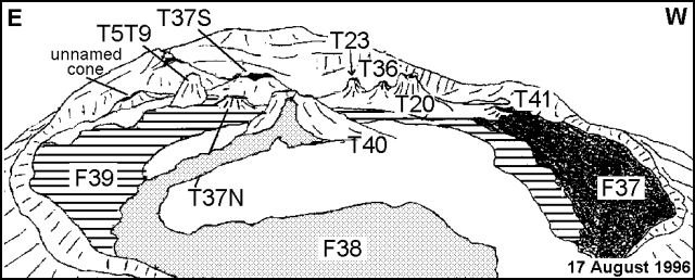 |
Figure 45. Sketch of the Ol Doinyo Lengai crater looking S from the N rim, 17 August 1996. Courtesy of Christoph Weber, revised by C. Nyamweru. |
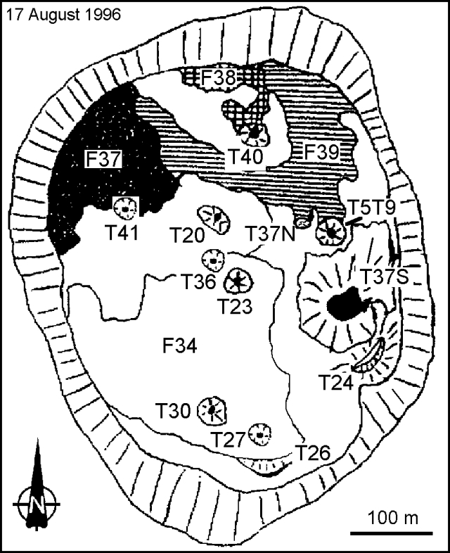 |
Figure 46. Sketch map of the Ol Doinyo Lengai crater, 17 August 1996. Courtesy of Christoph Weber, revised by C. Nyamweru. |
Geological Summary. The symmetrical Ol Doinyo Lengai is the only volcano known to have erupted carbonatite tephras and lavas in historical time. The prominent stratovolcano, known to the Maasai as "The Mountain of God," rises abruptly above the broad plain south of Lake Natron in the Gregory Rift Valley. The cone-building stage ended about 15,000 years ago and was followed by periodic ejection of natrocarbonatitic and nephelinite tephra during the Holocene. Historical eruptions have consisted of smaller tephra ejections and emission of numerous natrocarbonatitic lava flows on the floor of the summit crater and occasionally down the upper flanks. The depth and morphology of the northern crater have changed dramatically during the course of historical eruptions, ranging from steep crater walls about 200 m deep in the mid-20th century to shallow platforms mostly filling the crater. Long-term lava effusion in the summit crater beginning in 1983 had by the turn of the century mostly filled the northern crater; by late 1998 lava had begun overflowing the crater rim.
Information Contacts: Celia Nyamweru, Department of Anthropology, St. Lawrence University, Canton, NY 13617 USA; Christoph Weber, Kruppstrasse 171, 42113 Wuppertal, Germany.