Report on Yasur (Vanuatu) — September 1996

Bulletin of the Global Volcanism Network, vol. 21, no. 9 (September 1996)
Managing Editor: Richard Wunderman.
Yasur (Vanuatu) Strombolian activity during July from three summit craters within the main crater
Please cite this report as:
Global Volcanism Program, 1996. Report on Yasur (Vanuatu) (Wunderman, R., ed.). Bulletin of the Global Volcanism Network, 21:9. Smithsonian Institution. https://doi.org/10.5479/si.GVP.BGVN199609-257100
Yasur
Vanuatu
19.532°S, 169.447°E; summit elev. 361 m
All times are local (unless otherwise noted)
Although very intense activity was recorded during 1994, volcanism decreased in 1995 and was at normal levels (explosions, lava fountaining, and ash emissions) in November 1995. After a period of significant increase in the number and intensity of explosions during June 1996, activity returned to a quieter, but sustained, level (figure 6).
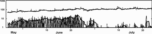 |
Figure 6. Seismicity at Yasur recorded every 4 hours by the seismometer 2 km from the summit, 24 May-23 July 1996. The upper line shows all events with a seismograph displacement greater than 12 µm. The vertical bars on the bottom of the graph indicate the number of larger events, those with a displacement greater than 60 µm. Thick lines are an 8-measurement (32-hour) running mean. Note that the scale is logarithmic. Courtesy of ORSTOM. |
Observations made during 3-5 July showed that explosive Strombolian activity was fairly significant. Heavy ash-and-steam plumes, visible from surrounding villages, frequently rose several hundreds of meters above the volcano, accompanied by loud rumbling/roaring noises. The summit crater is ~250 m deep, and is occupied by three smaller active craters (figure 7). During observation the explosive activity and intense degassing came from six vents (one in Crater A; three in Crater B; two in Crater C).
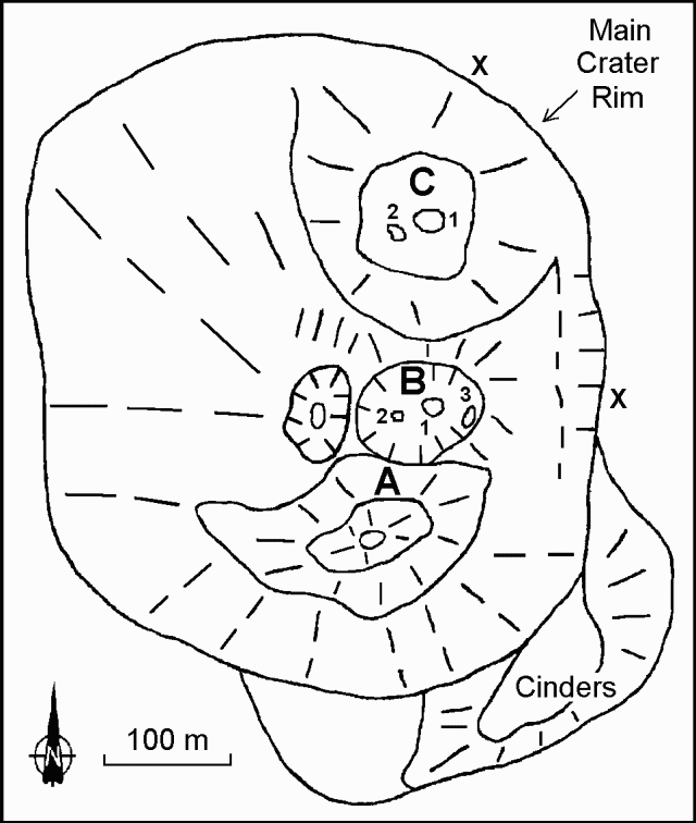 |
Figure 7. Sketch map showing the summit craters at Yasur, 3-5 July 1996. Observation points are indicated by an "X". Courtesy of Henry Gaudru, SVE. |
Crater A was a pit with a S vertical wall ~100 m high. On the morning of 3 July between 1130 and 1330 the activity was principally characterized by frequent and intermittent explosions that generated ejections of magma fragments to several dozens of meters above the vent, sometimes surpassing the upper rim of the crater. A steam-and-ash plume regularly followed the explosive activity.
Crater B, smaller than A and separated from it by a small wall, had more sustained explosive activity from several vents, of which two (B1-B2) were particularly active with strong degassing. Bombs were regularly ejected >300 m vertically, often surpassing the highest point on the crater rim. The most active vent (B1) showed activity phases of continuous, very violent jets that lasted between 1 and 5 minutes, notably between 1930 and 2230 on 3 July. Pressurized gas intermittently generated a blue-orange flame. Good-sized magma fragments projected several meters above this vent were accompanied by strong detonations and intense degassing. Based on calculations made following several hours of observations, the ejection speed was estimated at 230-250 m/second. A third vent (B3) near the E rim was also very active but in a less violent and frequent manner. Two other vents, more westward, visible for an instant, showed mainly intense degassing sometimes accompanied by magma ejections to some meters above the red glow.
Crater C is a large depression with a lava lake in its center, usually agitated by surface movements. Violent explosions sent heavy gray-black ash plumes several hundreds of meters above the crater. Weak magma ejections also occurred from a glowing zone SW of the main lava lake. On the night of 3-4 July an intermittent flame came from the interior of this pit. Several times during the night, Strombolian explosions occurred simultaneously in these two areas.
A count of magma-ejecting explosions made over three 1-hour periods showed that Crater B was consistently more active. On 3 July between 1800 and 1900 a total of 63 explosions were distributed as follows: Crater A, 10; Crater B, 33; Crater C, 20. On 3 July between 2030 and 2130 a total of 51 explosions were distributed as follows: Crater A, 8; Crater B, 26; Crater C, 17. On 4 July between 1000 and 1100 a total of 54 explosions were distributed as follows: Crater A, 10; Crater B, 28; Crater C, 16.
On 5 July between 1430 and 1600, activity was much less frequent than the previous days, with explosions followed by long minutes of silence. The lava lake was quite visible in Crater C. During this period craters A and C were more active than B. At 1545 a larger explosion from Crater B generated some bomb falls at the extreme edge of the crater.
Geological Summary. Yasur has exhibited essentially continuous Strombolian and Vulcanian activity at least since Captain Cook observed ash eruptions in 1774. This style of activity may have continued for the past 800 years. Located at the SE tip of Tanna Island in Vanuatu, this pyroclastic cone has a nearly circular, 400-m-wide summit crater. The active cone is largely contained within the small Yenkahe caldera, and is the youngest of a group of Holocene volcanic centers constructed over the down-dropped NE flank of the Pleistocene Tukosmeru volcano. The Yenkahe horst is located within the Siwi ring fracture, a 4-km-wide open feature associated with eruption of the andesitic Siwi pyroclastic sequence. Active tectonism along the Yenkahe horst accompanying eruptions has raised Port Resolution harbor more than 20 m during the past century.
Information Contacts: Henry Gaudru, C. Pittet, C. Bopp, and G. Borel, Société Volcanologique Européenne, C.P. 1, 1211 Genève 17, Switzerland (URL: http://www.sveurop.org/); Michel Lardy, Centre ORSTOM, B.P. 76, Port Vila, Vanuatu.