Report on Kama'ehuakanaloa (United States) — September 1996
Bulletin of the Global Volcanism Network, vol. 21, no. 9 (September 1996)
Managing Editor: Richard Wunderman.
Kama'ehuakanaloa (United States) Active hydrothermal venting, turbid water, and debris slides
Please cite this report as:
Global Volcanism Program, 1996. Report on Kama'ehuakanaloa (United States) (Wunderman, R., ed.). Bulletin of the Global Volcanism Network, 21:9. Smithsonian Institution. https://doi.org/10.5479/si.GVP.BGVN199609-332000
Kama'ehuakanaloa
United States
18.92°N, 155.27°W; summit elev. -975 m
All times are local (unless otherwise noted)
The onset of an intense earthquake swarm, which began in mid-July, prompted a rapid-response cruise and submersible dives during early August (BGVN 21:07). Scientists from the University of Hawaii once again used the research vessel Ka'imikai O Kanaloa (R/V KOK) and PISCES V manned submersible to carry out two follow-up research cruises over Lōʻihi during 26-28 September and 2-10 October, respectively. The following summarized observations are from reports of the Hawaii Center for Volcanology.
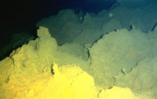
Observations on 26-28 September. During 26 September the divers found hydrothermal venting on the bottom of the newly formed Pele's Pit (figure 9). In the summit area N of East Pit, no volcanic activity was observed, but a number of broken-up pillows were discovered. There was no activity at West Pit, however, the divers saw columnar basalt that appeared to be teetering due to collisions from debris slides. Some noise was heard with sonobuoys the next day. In East Pit on 27 September, divers saw a mudslide but no venting. Visibility was poor due to particles coming from Pele's Pit via a channel between the two pits. In Pele's Pit, active venting was observed on the upper W wall below Pele's Lookout. The divers encountered vents early during the dive on 28 September. The dive was aborted after the submersible brushed an unseen wall and damaged a thruster.
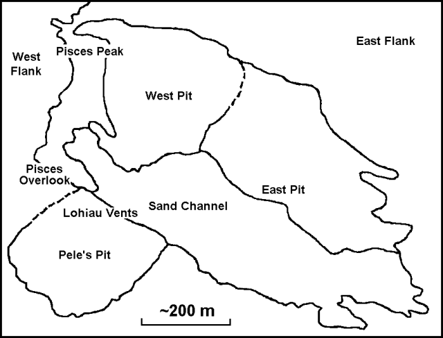 |
Figure 9. Sketch map of the Lōʻihi Seamount. View is from the SSE. After Carlowicz (1996); original image by J.R. Smith, Jr., University of Hawaii. |
Observations on 2-3 October. The dive on 2 October began in the "sand channel" between the pre-existing East Pit and the new Pele's Pit. The bottom of the channel was covered with a thick layer of fine-grained sediments. A miniature temperature recorder (MTR) was deployed, and a maximum vent-fluid temperature of >18°C was measured. At the W end of the vent field at Pele's Pit (1,175-m depth), numerous vents were seen; most were covered with white, streaming mats. This area, dubbed the rubble zone, extended perhaps 50-60 m in diameter, and was marked with several locations of recent slides and a few relatively stable benches. At night a tow-yo survey of nearly 18-km length was run up the W side of the main N-S axis of the seamount. A nephelometer detected a large number of plumes over the N half of the survey concentrated at ~1,350 and 1,050 m depth beside a large summit plume at a depth of ~1,150 m.
Vents were found the next day with a maximum vent-fluid temperature of 77°C, a much higher temperature than any previously measured at Lōʻihi. A hydrocast into Pele's Pit showed that water-temperature anomalies had greatly decreased after the rapid-response cruise in August (a few tenths of a degree vs. three degrees). However, a distinct turbidity maximum remained in the bottom waters.
Observations on 4-6 October. A submersible dive up the S rift was conducted to investigate the origin of a hydrothermal plume at 1,350-m depth detected on 2 October. A new hydrothermal vent field was found on the rift axis at 1,325-m depth, and was named "Naha Vents". This extensive vent field contained many fresh fractures, including a fissure (1-3 m wide) that vented large volumes of water. A smaller vent had a measured temperature of 11.2°C. The dive concluded farther up the rift at the site of the previously active Kapo's Vents (1,250-m depth); no hydrothermal activity was observed there. At night a ship-based water sampling program included a ~13 km long SW-NE tow-yo survey across the summit (the tow was run parallel to the predominantly NE current). A hydrothermal plume was first detected 6.5 km downcurrent from the summit.
Observations on 5 October showed that the Naha vent field was ~20 x 30 m, and was heavily covered with nontronite deposits and tan bacterial mats. The field contained many small vents, as well as diffuse flows through fractured pillows and large fissures. The highest vent-fluid temperature was 22.7°C. Night water sampling (vertical hydrocast) 1.4 km downcurrent (NE) from the summit revealed six major turbidity maxima at depths of 1,050-1,330 m. The strongest signal, at 1,080 m, was associated with a significant temperature anomaly. This suggested that there might be an undiscovered major source of venting at the summit (all of the vents discovered thus far are below 1,180 m).
Water sampling the night of 6 October better located the sources of the large shallow (1,000-1,105 m depth) turbidity and temperature-anomaly maxima observed on 5 October. Hydrocasts and tow-yos across the seamount suggested that a major venting site should be just S of Pele's Pit near the top of the S rift.
Observations on 7-10 October. An MTR showed a slow increase in temperature from 48 to 53°C over its deployment during 4-7 October, with some daily variations. The dive on 7 October explored a site covered with nontronite-coated gravels where diffuse venting was observed at a depth of 1,099 m. This field was likely an early stage of the "finger vent"-type hydrothermal fields seen previously on Lōʻihi, and was named "Ula Vents". The dive concluded on the steep W flank of the summit at a site of previously observed intermittent venting (Maximilian Vents) at 1,249-m depth. A night water sampling program ran two perpendicular 5-km-long tow-yo sections near the summit. In the both runs, plume maxima were in the vicinity of Kapo's Vents. A hydrocast at West Pit indicated a substantial particle plume above the pit with no associated temperature anomaly.
The 8 October dive began just W of the site of Kapo's Vents, a small field that was active in the late 1980s. As on the section of the S rift already explored, large volumes of clay- to gravel-sized sediments covered much of the area. Pele's hair and flat sheets of glass that formed as walls of large lava bubbles were common. One interesting feature was ~5-cm-diameter holes at several sites in the sand layer that appeared to be locations of recently terminated venting. An area of modest venting through a mound of small nontronite-covered boulders was found at a depth of 1,196 m. A maximum vent-fluid temperature of 17.2°C was measured. At night a S-to-N tow 3 km W of the seamount axis showed that the bulk of the hydrothermal plume above Lōʻihi had shifted from the WSW to the NE over the previous few days.
Dive operations the next day focused on completing work at Lohiau Vents. The dive finished at the E end of the vent field and collected rocks bearing several high-temperature sulfide minerals; these suggested that vent-fluid temperatures during the July-August seismic event might have been much higher. The hydrothermal site sampled on 8 October at a depth of 1,196 m on the S rift was confirmed to be a new field. It was named "Pohaku Vents".
On 10 October, a repeat of the tow-yo section made on 8 October revealed that the plume had shifted to nearly due N. This shift during only a few days indicated the speed at which the ocean currents carrying the Lōʻihi plumes could change their orientation. During the whole cruise, 71 km of tow-yos were conducted, making Lōʻihi one of the most intensively studied submarine hydrothermal systems.
Reference. Carlowicz, M., 1996, Earthquake swarm heats up Lōʻihi: EOS, v. 77, no. 42, p. 405-406.
Geological Summary. The Kama’ehuakanaloa seamount, previously known as Loihi, lies about 35 km off the SE coast of the island of Hawaii. This youngest volcano of the Hawaiian chain has an elongated morphology dominated by two curving rift zones extending north and south of the summit. The summit region contains a caldera about 3 x 4 km and exhibits numerous lava cones, the highest of which is about 975 m below the ocean surface. The summit platform also includes two well-defined pit craters, sediment-free glassy lava, and low-temperature hydrothermal venting. An arcuate chain of small cones on the western edge of the summit extends north and south of the pit craters and merges into the crests prominent rift zones. Seismicity indicates a magmatic system distinct from that of Kilauea. During 1996 a new pit crater formed at the summit, and lava flows were erupted. Continued volcanism is expected to eventually build a new island; time estimates for the summit to reach the ocean surface range from roughly 10,000 to 100,000 years.
Information Contacts: Hawaii Center for Volcanology, Department of Geology & Geophysics, University of Hawaii at Manoa, 2525 Correa Road, Honolulu, HI 96822 USA (URL: http://www.soest.hawaii.edu/GG/hcv.html); Hawaiian Volcano Observatory (HVO), U.S. Geological Survey, PO Box 51, Hawaii National Park, HI 96718, USA (URL: http://www.soest.hawaii.edu/hvo/).