Report on Whakaari/White Island (New Zealand) — November 1996

Bulletin of the Global Volcanism Network, vol. 21, no. 11 (November 1996)
Managing Editor: Richard Wunderman.
Whakaari/White Island (New Zealand) Inflating and heating trends cease and reverse
Please cite this report as:
Global Volcanism Program, 1996. Report on Whakaari/White Island (New Zealand) (Wunderman, R., ed.). Bulletin of the Global Volcanism Network, 21:11. Smithsonian Institution. https://doi.org/10.5479/si.GVP.BGVN199611-241040
Whakaari/White Island
New Zealand
37.52°S, 177.18°E; summit elev. 294 m
All times are local (unless otherwise noted)
During 4-5 November, surveillance visits were made by scientists from the Institute of Geological & Nuclear Sciences (IGNS), Canterbury University, Otago University, Victoria University, Michigan Technology University, and California Institute of Technology.
Like monitoring results on 28 August (BGVN 21:09), these visits showed a continuation of the crater-wide deformation and heating reversal. This reversal suggested that a major long-term inflationary and heating pulse had peaked and that the probability of a significant eruption might be low in the short term.
Crater observations. A crater lake continued to occupy the floor of the 1978/90 Crater Complex (figure 24). Green coloration developed in the lake with blue-gray surface slicks. The coloration change from gray- brown to green in August-September suggested that there was less vigorous input into the lake with less or no convection. On 5 November, the water temperature of the lake was 58.2°C. A rapid fall of the lake level occurred, with the water level of the lake dropping 5-10 m during the week preceding the visit.
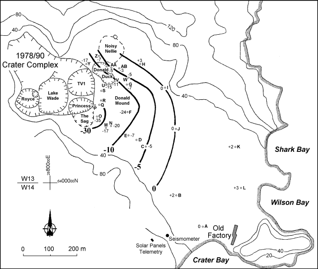 |
Figure 24. Relative height changes at White Island between 28 August and 4 November 1996. Numbers beside circles are relative height changes at individual pegs (in millimeters). Heavy contours (in millimeters) show relative height changes; light contours (in meters) show topography. Courtesy of B.J. Scott, IGNS. |
The steep margins of the 1978/90 Crater Complex continued to fall, and several fresh landslide scars were visible around the crater wall. Similar activity also occurred in Donald Duck Crater.
Fumarole activity near Donald Mound continued to change. Many areas previously holding mud pots or pools had dried out and contained low-pressure fumaroles; maximum temperatures had decreased from 311°C on 28 August to 268°C. In contrast, beginning in late September, Noisy Nellie was almost full of water and sometimes overflowed. Several fluid seeps also developed in Noisy Nellie along with substantial landsliding off the Main Crater wall.
Deformation. A leveling survey of the White Island network was made on 4 November, with some sections repeated on 5 November. This survey revealed a continuation of the reversal of the inflationary trend first observed on 28 August (BGVN 21:09). Subsidence was apparent across the Main Crater floor, increasing toward the 1978/90 Crater Complex and Donald Mound (figure 24). Compared with the inflation from 1992, the recent subsidence was quite small (figures 24 and 25).
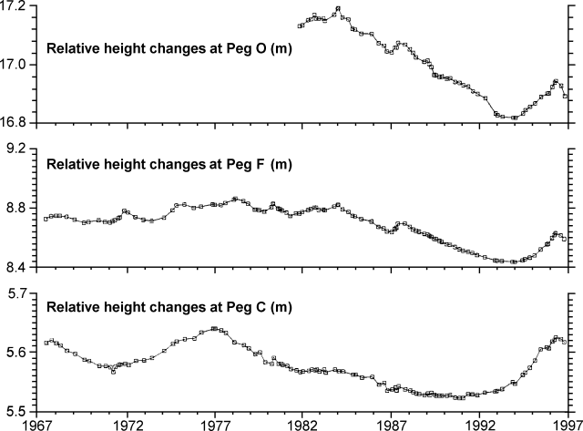 |
Figure 25. Relative height changes (in meters) with time at pegs C, F, and O in the White Island crater. Courtesy of B.J. Scott, IGNS. |
Magnetic survey. Magnetic changes between 16 May and 4 November were dominated by a positive anomaly over most of the N part of the Main Crater centered just E of Donald Mound. A less intense anomaly occurred S of the Main Crater. These features suggested shallow (50-100 m deep) cooling on the E side of Donald Mound, probably a broadening of the cooling trend observed between 12 December 1995 and 16 May 1996 (BGVN 21:09).
Another significant trend was the negative anomaly to the N of Donald Mound, which appeared to be a continuation of the trend seen in this area since late 1995. These magnetic decreases might be due to shallow (100 m deep?) heating on the E side of the 1978/90 Crater or possibly to chemical demagnetization.
The overall magnetic pattern appeared to be the reverse of the trend from late 1993 to early 1995. However, the earlier trend did not reverse in magnitude, and lower temperatures on the E side of Donald Mound did not necessarily mean that the total heat flow was reduced. The continuing collapses along the E edge of the 1978/90 Crater Complex probably diverted more heat flow, and high temperatures (above ~450°C for significant thermo-magnetic effects to occur) were no longer sustainable near the surface.
Geological Summary. The uninhabited Whakaari/White Island is the 2 x 2.4 km emergent summit of a 16 x 18 km submarine volcano in the Bay of Plenty about 50 km offshore of North Island. The island consists of two overlapping andesitic-to-dacitic stratovolcanoes. The SE side of the crater is open at sea level, with the recent activity centered about 1 km from the shore close to the rear crater wall. Volckner Rocks, sea stacks that are remnants of a lava dome, lie 5 km NW. Descriptions of volcanism since 1826 have included intermittent moderate phreatic, phreatomagmatic, and Strombolian eruptions; activity there also forms a prominent part of Maori legends. The formation of many new vents during the 19th and 20th centuries caused rapid changes in crater floor topography. Collapse of the crater wall in 1914 produced a debris avalanche that buried buildings and workers at a sulfur-mining project. Explosive activity in December 2019 took place while tourists were present, resulting in many fatalities. The official government name Whakaari/White Island is a combination of the full Maori name of Te Puia o Whakaari ("The Dramatic Volcano") and White Island (referencing the constant steam plume) given by Captain James Cook in 1769.
Information Contacts: B.J. Scott, Colin Wilson, B.F. Houghton, and I. Nairn, Institute of Geological & Nuclear Sciences (IGNS), Private Bag 2000, Wairakei, New Zealand.