Report on Kilauea (United States) — November 1996

Bulletin of the Global Volcanism Network, vol. 21, no. 11 (November 1996)
Managing Editor: Richard Wunderman.
Kilauea (United States) Eruptive activity continues; lava-bench collapses
Please cite this report as:
Global Volcanism Program, 1996. Report on Kilauea (United States) (Wunderman, R., ed.). Bulletin of the Global Volcanism Network, 21:11. Smithsonian Institution. https://doi.org/10.5479/si.GVP.BGVN199611-332010
Kilauea
United States
19.421°N, 155.287°W; summit elev. 1222 m
All times are local (unless otherwise noted)
During October and November, eruptive activity along the east rift zone continued without significant change. Lava issued at a rate of 4.6 m3/second from a vent on the W flank of the Pu`u `O`o cinder cone, and flowed through a network of lava tubes for 10 km to the ocean entry at Lae`apuki (figure 102). The lava pond within Pu`u `O`o was 75-85 m below the crater rim during October and November, and was divided into two reservoirs that circulated, drained, and filled independently. The lava tubes were quite stable, and almost no surface flows were seen after the end of August. Large, billowing steam plumes, tinged with red at night, marked the main points of discharge, which lay near the central edge of a 100-m-wide lava bench. Mild explosive activity and splattering were sometimes observed when lava flowed into the surf. Small littoral cones, a few meters high, grew sporadically above the discharge points. Bench collapses occurred during the week of 2-8 November, and about a quarter of the bench slid into the sea.
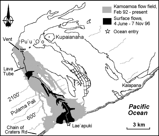 |
Figure 102. Map of recent lava flows from Kīlauea's east rift zone, June-November 1996. Contours are in feet. Courtesy of the Hawaiian Volcano Observatory, USGS. |
The current eruption began in January 1983 and has emitted >1 km3 of lava, which has destroyed 181 homes and the National Park visitor center.
Geological Summary. Kilauea overlaps the E flank of the massive Mauna Loa shield volcano in the island of Hawaii. Eruptions are prominent in Polynesian legends; written documentation since 1820 records frequent summit and flank lava flow eruptions interspersed with periods of long-term lava lake activity at Halemaumau crater in the summit caldera until 1924. The 3 x 5 km caldera was formed in several stages about 1,500 years ago and during the 18th century; eruptions have also originated from the lengthy East and Southwest rift zones, which extend to the ocean in both directions. About 90% of the surface of the basaltic shield volcano is formed of lava flows less than about 1,100 years old; 70% of the surface is younger than 600 years. The long-term eruption from the East rift zone between 1983 and 2018 produced lava flows covering more than 100 km2, destroyed hundreds of houses, and added new coastline.
Information Contacts: Hawaiian Volcano Observatory (HVO), U.S. Geological Survey, PO Box 51, Hawaii National Park, HI 96718, USA (URL: http://www.soest.hawaii.edu/hvo/).