Report on Pacaya (Guatemala) — November 1996

Bulletin of the Global Volcanism Network, vol. 21, no. 11 (November 1996)
Managing Editor: Richard Wunderman.
Pacaya (Guatemala) Eruption on 11 November drops over 3.5 cm of ash
Please cite this report as:
Global Volcanism Program, 1996. Report on Pacaya (Guatemala) (Wunderman, R., ed.). Bulletin of the Global Volcanism Network, 21:11. Smithsonian Institution. https://doi.org/10.5479/si.GVP.BGVN199611-342110
Pacaya
Guatemala
14.382°N, 90.601°W; summit elev. 2569 m
All times are local (unless otherwise noted)
INSIVUMEH reports further described volcanic activity in October (BGVN 21:09) and a more forceful eruption that began on 11 November. Seismic data were registered at a local, one-component station (exact location undisclosed).
Activity during October 1996. At about noon on 4 October the volcano produced a 20-minute- long eruption of pyroclastics that reached 100-150 m above the crater rim. Less sustained eruptions followed later that day.
A small phreatic eruption occurred the next day (between 1000 and 1330 on 5 October), throwing pyroclastics 300-400 m high and generating an ash-bearing column rising 600 m above MacKenney crater. After that, activity generally continued as smaller explosions. Specifically, these explosions occurred at intervals of 2-5 seconds, typically throwing incandescent material to 20-30 m; but at intervals of 1-3 minutes, more energetic explosions sent material to 150 m. In response to unbroken eruptions on the morning of 6 October, a sustained column developed that was 100 m tall.
On 7 October outbursts increased in vigor with incandescent discharges 70-150 m high and coffee-colored clouds blowing E. At the seismic station, strong harmonic tremor was recorded. As a result of these factors, an alert was given to authorities. On 8 October the tremor fluctuated in amplitude but continued and a sustained 15-minute eruption led to a column reaching 200 m above MacKenny crater. The vigor of eruptions dropped noticeably later on 8-9 October.
Between 2300 and 0200 on 10-11 October, a moderate Strombolian eruption took place (BGVN 21:09). Although previously unreported, pyroclastic flows during the eruption ran down Pacaya's N, E, and S flanks reaching the cone's base. Some forceful phases of the eruption sent ash to 700- and 800-m heights. Winds of 35 km/hour from the NNE, gusting to 45 km/hour, blew ash toward the towns of Esquintla, 25 km SW, and Puerto San Jose, 60 km SE. Fine ash was also detected as far away as the Salvadorian border, 120 km SSE. Tephra with grain sizes of 0.5-3 cm reached distances of 4-7 km from the source. Evacuees from the village of El Patrocinio (3.6 km W of the crater) returned on the afternoon of 11 October. That day seven hours of post-eruption tremor registered and a bluish white plume stood 30-70 m above the crater rim. The volcano was quiet between 12 and 13 October except for 30 microseisms with 3-7 second durations.
A swarm of microseisms during 0900-1900 on 14 October consisted of 70 events of 5-10 second duration. On 15-16 October the volcano was seismically quiet but on 17 October there was an 11-hour period when seven lava avalanches broke loose. These typically took 1-3 minutes to reach the base of the cone. Five more avalanches followed on 18 October, and others followed later as freshly erupted lava and debris moved downslope. On 19 and 20 October only sporadic microseisms registered (2-15 mm peak-to-peak with 5-15 second periods); these originated at 3-5 km depths beneath the cone. Various types of weak tremor reappeared again during 21-25 October with 3- to 15-minute durations.
During 19-25 October, except for the above-noted seismic events, there were no earthquakes registered; plumes were bluish to white, and rose to 300-350 m in height. Despite technical problems with the seismograph on 26 and 27 October, some microseisms were registered; on 28 October weak tremor occurred during the entire day and 5-15 type-B earthquakes took place each hour. Elevated but fluctuating seismicity continued through the end of October.
Vigorous blue-to-white columns poured out of the MacKenny crater on 26-28 October; these were carried by 25-35 km/hour N winds. Weak fumarolic emissions took place along the N segment of the cone's base. A steamy column rose to 100-150 m high and was blown S.
Activity during November 1996. After 2 November there were repeated explosions that sent puffs of steam 30-100 m above the MacKenny crater floor. Poor visibility kept observers from seeing whether pyroclastic material was ejected; however, during 1-7 November wide steam columns reached 300 m.
The week of 1-8 November included extensive intervals of weak tremor and other minor events; in the most extreme example, on 1 November, tremor was continuous. Other events included a series of type-A earthquakes that took place in an 18-hour interval on 3 November. This swarm consisted of 63 events at depths of 200-700 m. Type-B earthquakes were also common.
On 9 November tremor was relatively scarce, only about one hour in total duration, but on 10 November four hours of tremor took place. RSAM estimates made at 10-minute intervals were constant through 0900 on 11 November when the register reset.
Initial Strombolian explosive activity from MacKenny crater began at 0930 on 11 November. Although the crater was not visible, strong-to-moderate explosions could be heard 4 and 3 km away (at the villages of El Patrocinio and San Francisco de Sales, figure 18); these continued until 1142 when a 15-minute interval of stronger explosions began that included incandescent material thrown 70 m above the crater rim; at 1157 the explosions became more frequent (4-12 each minute) and stronger (throwing incandescent material ~100 m above the crater).
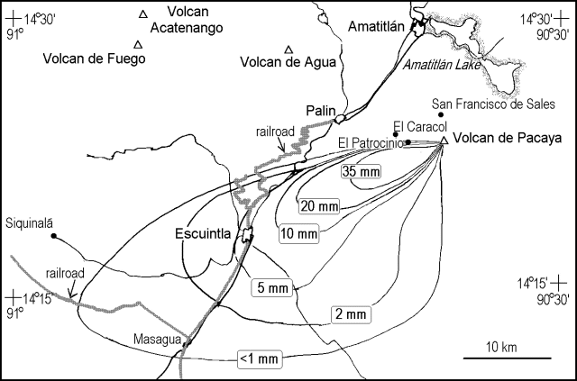 |
Figure 18. Isopach map of Pacaya's 11 November eruption. Courtesy of Otoniel Matías, INSIVUMEH. |
During the course of the 11 November eruption lava progressively rose to the crater rim, and about midday, coincident with a sustained burst of incandescent ejections, lava spilled out over the WSW flank. The associated incandescent material rose ~100 m and a steam column rose to ~200 m. By 1330 the lava flow had reached 450 m in length traveling in a SW direction, and the column of incandescent material rose ~300 m.
At 1645 on 11 November the eruptive column rose dramatically, reaching at least 1.1 km tall. Falling ash was reported as far away as the town of Esquintla (figure 18). Meanwhile, the escaping lava flow reached 1 km in length and small tongues of lava 200-300 m in length fell from the breach in the crater. Incandescent avalanches moved down the cone's S flank and some reached as far as the base. A Red alert was recommended at midday on 11 November; evacuations followed at nearby villages. About 1900 on 11 November the lava flow reached the cone's SE base, a distance of ~2 km. About this time, large lapilli rained down on the fields and forests of the region damaging vegetation.
Figure 18 shows the isopach map resulting from these 11 November eruptions. Within the 35 mm isopach tephra ranged from 2 x 3 cm to 4 x 6 cm. Inside the <1 mm isopach there were only traces of ash. Small eruptions continued into December.
Pacaya lies 30 km S of Guatemala City, an urban center with a population of over 1.5 million people. The volcano's olivine-basaltic lavas have often flowed out of the collapsed SSW sector travelling away from most inhabited areas.
Geological Summary. Eruptions from Pacaya are frequently visible from Guatemala City, the nation's capital. This complex basaltic volcano was constructed just outside the southern topographic rim of the 14 x 16 km Pleistocene Amatitlán caldera. A cluster of dacitic lava domes occupies the southern caldera floor. The post-caldera Pacaya massif includes the older Pacaya Viejo and Cerro Grande stratovolcanoes and the currently active Mackenney stratovolcano. Collapse of Pacaya Viejo between 600 and 1,500 years ago produced a debris-avalanche deposit that extends 25 km onto the Pacific coastal plain and left an arcuate scarp inside which the modern Pacaya volcano (Mackenney cone) grew. The NW-flank Cerro Chino crater was last active in the 19th century. During the past several decades, activity has consisted of frequent Strombolian eruptions with intermittent lava flow extrusion that has partially filled in the caldera moat and covered the flanks of Mackenney cone, punctuated by occasional larger explosive eruptions that partially destroy the summit.
Information Contacts: Eddy Sanchez and Otoniel Matías, Seccion Vulcanologia, INSIVUMEH (Instituto Nacional de Sismologia, Vulcanologia, Meteorologia e Hydrologia of the Ministerio de Communicaciones, Transporte y Obras Publicas), 7A Avenida 14-57, Zona 13, Guatemala City, Guatemala.