Report on Piton de la Fournaise (France) — December 1996

Bulletin of the Global Volcanism Network, vol. 21, no. 12 (December 1996)
Managing Editor: Richard Wunderman.
Piton de la Fournaise (France) November intrusion signaled by radon and geophysical measurements
Please cite this report as:
Global Volcanism Program, 1996. Report on Piton de la Fournaise (France) (Wunderman, R., ed.). Bulletin of the Global Volcanism Network, 21:12. Smithsonian Institution. https://doi.org/10.5479/si.GVP.BGVN199612-233020
Piton de la Fournaise
France
21.244°S, 55.708°E; summit elev. 2632 m
All times are local (unless otherwise noted)
During the last four years, quiet prevailed at Piton de la Fournaise (figure 35), with unusually low seismic activity and no eruptions. During late November, however, scientists at the Observatoire Volcanologique du Piton de la Fournaise noted an increase in radon flux followed a day later by an increase in seismicity. This also accompanied changes in tilt, local extension, and larger-scale distance movements. These observations led the scientists to infer that there had been a magma intrusion.
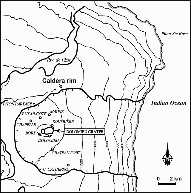 |
Figure 35. Sketch map of Piton de la Fournaise and vicinity showing the locations of observation stations. Notice that the topographic contour intervals on this map are uneven. Courtesy of OVPDLF. |
Seismicity. In September a 16-km-deep swarm of earthquakes was recorded ~5 km NW of the summit. Seismicity continued to increase under the summit, and a M 2.3 event was registered on 18 October. A short but intense seismic crisis (figure 36), which began at 2126 on 26 November, consisted of 134 registered events. Among them, there were 37 earthquakes larger than M 1 and two in the range of M 2-2.4. The strongest one took place at 2149, an event nearly coincident with changes recorded by inclinometers and extensometers and inferred to correspond to the beginning of the principal magma movement. The seismic activity decreased at 2220 and ended with a final event of M 1.9 at 2310. After that, seismicity remained low. All events during this seismic crisis originated at about sea level ( ~2.5 km below the summit) at the Soufrière region, slightly N of the summit.
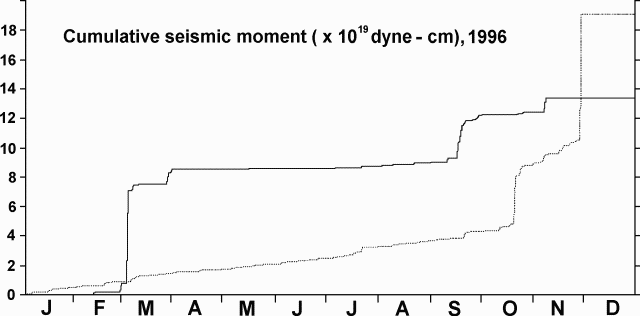 |
Figure 36. Cumulative seismic moment during January-November 1996 at Piton de la Fournaise. Thin dotted line shows cumulative seismic moment under the summit; heavier line represents volcano-wide cumulative seismic moment minus the cumulative seismic moment under the summit. Courtesy of OVPDLF. |
Tilt and extension. Although not shown in figure 37, a small amount of ground movement might have taken place prior to the prominent tilt event at about 2149 on 26 November. The tilt accompanied inflation of the summit region, and tilts of 16, 8, and 4 µrad were recorded at stations Soufrière, Dolomieu, and Bory, respectively. Stations Chapelle and Chateau Fort at the base of the cone tilted less than 1 µrad. Displacements of less than 0.1 mm were also recorded by extensometers at stations Magne, Chateau Fort, Soufriere, and Dolomieu.
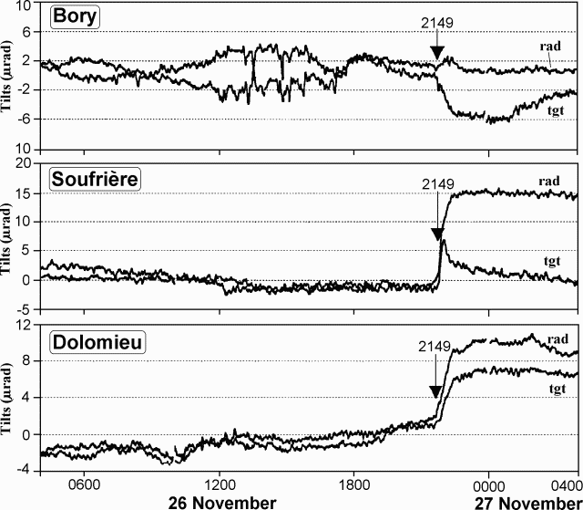 |
Figure 37. Tilts at stations Bory, Soufriére, and Dolomieu at Piton de la Fournaise. "Rad" and "tgt" refer to radial and tangential components, respectively. Courtesy of OVPDLF. |
Distance change. Distances between station Piton Partage and different prisms on the cone were measured automatically by a TM3000 instrument (figure 38). During 25-26 November, a decrease up to 10 mm occurred for prisms on the profile between Soufrière and Puy Mi-Cote (prisms 1M20, 2M54, 2M53, 2M52, 2M42, and 1M40). In addition, the distance decreased slightly for one prism at Magne (2M26); no distance change was observed for the prisms between Chapelle and Bory and for one prism at the E side of the cone (2M31).
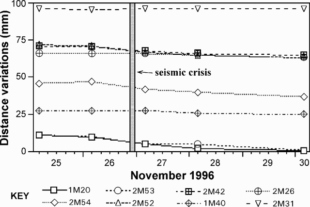 |
Figure 38. Distance changes between station Piton Partage and different prisms on the Piton de la Fournaise volcanic cone. Courtesy of OVPDLF. |
Radon. None of the six radon stations transmitted by radio showed significant changes during the seismic crisis; however, about 36 hours before the crisis, two of the stations, Chateau Fort and Cratere Catherine, recorded distinct Gaussian-like anomalies for a period of 15 hours. These changes were significantly above the background signal of 1-5 counts per hour (figure 39). Thus increased radon flux might have been a precursor to the intrusion.
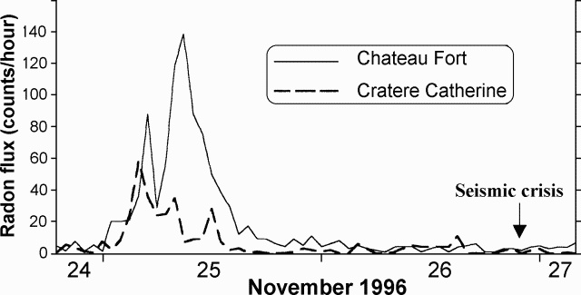 |
Figure 39. Radon flux at stations Chateau Fort and Cratere Catherine at Piton de la Fournaise. Courtesy of OVPDLF. |
Geological Summary. Piton de la Fournaise is a massive basaltic shield volcano on the French island of Réunion in the western Indian Ocean. Much of its more than 530,000-year history overlapped with eruptions of the deeply dissected Piton des Neiges shield volcano to the NW. Three scarps formed at about 250,000, 65,000, and less than 5,000 years ago by progressive eastward slumping, leaving caldera-sized embayments open to the E and SE. Numerous pyroclastic cones are present on the floor of the scarps and their outer flanks. Most recorded eruptions have originated from the summit and flanks of Dolomieu, a 400-m-high lava shield that has grown within the youngest scarp, which is about 9 km wide and about 13 km from the western wall to the ocean on the E side. More than 150 eruptions, most of which have produced fluid basaltic lava flows, have occurred since the 17th century. Only six eruptions, in 1708, 1774, 1776, 1800, 1977, and 1986, have originated from fissures outside the scarps.
Information Contacts: Thomas Staudacher; Patrick Bachèlery; Valéry Ferrazzini, and Kei Aki, Observatoire Volcanologique du Piton de la Fournaise (OVPDLF), 14 RN3, le 27Km, 97418 La Plaine des Cafres, La Réunion, France.