Report on McDonald Islands (Australia) — January 1997
Bulletin of the Global Volcanism Network, vol. 22, no. 1 (January 1997)
Managing Editor: Richard Wunderman.
McDonald Islands (Australia) Apparent volcanic plume sighted on 5 January
Please cite this report as:
Global Volcanism Program, 1997. Report on McDonald Islands (Australia) (Wunderman, R., ed.). Bulletin of the Global Volcanism Network, 22:1. Smithsonian Institution. https://doi.org/10.5479/si.GVP.BGVN199701-234011
McDonald Islands
Australia
53.03°S, 72.6°E; summit elev. 230 m
All times are local (unless otherwise noted)
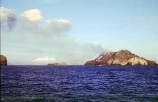
[Originally reported under Heard.]
On 5 January, a pilot on an Antarctic sightseeing tour near Heard Island saw what appeared to be a volcanic plume.
Geological Summary. Historical eruptions have greatly modified the morphology of the McDonald Islands, located on the Kerguelen Plateau about 75 km W of Heard Island. The largest island, McDonald, is composed of a layered phonolitic tuff plateau cut by phonolitic dikes and lava domes. A possible nearby active submarine center was inferred from phonolitic pumice that washed up on Heard Island in 1992. Volcanic plumes were observed in December 1996 and January 1997 from McDonald Island. During March 1997 the crew of a vessel that sailed near the island noted vigorous steaming from a vent on the N side of the island along with possible pyroclastic deposits and lava flows. A satellite image taken in November 2001 showed the island to have more than doubled in area since previous reported observations in November 2000. The high point of the island group had shifted to the McDonald's N end, which had merged with Flat Island.
Information Contacts: Andrew Tupper, Darwin RFC/RSMC/VAAC, Bureau of Meteorology, Northern Territory, Australia.