Report on Kilauea (United States) — January 1997

Bulletin of the Global Volcanism Network, vol. 22, no. 1 (January 1997)
Managing Editor: Richard Wunderman.
Kilauea (United States) New, short-lived eruptive episode (54) in Napau Crater; Pu`u `O`o pauses
Please cite this report as:
Global Volcanism Program, 1997. Report on Kilauea (United States) (Wunderman, R., ed.). Bulletin of the Global Volcanism Network, 22:1. Smithsonian Institution. https://doi.org/10.5479/si.GVP.BGVN199701-332010
Kilauea
United States
19.421°N, 155.287°W; summit elev. 1222 m
All times are local (unless otherwise noted)
During December and most of January, the dynamics of eruptive activity along the east rift zone continued without significant change; however, there were two prominent changes in landforms. On 2 December the coastal bench collapsed, removing 0.1 km2 of shoreline bench and 0.03 km2 of existing land that created a crescent-shaped embayment nearly 900 m long with widths up to 100 m. New lava continued to travel from a vent on the W flank of the Pu`u `O`o cinder cone through a 10-km-long network of lava tubes to the ocean entry at Lae'apuki (figure 103), quickly building a new subaerial bench in the W half of the embayment.
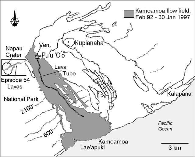 |
Figure 103. Map of recent lava flows from Kīlauea's east rift zone, February 1992 - 30 January 1997. Contours are in feet (3.28 feet = 1 meter). Courtesy of the Hawaiian Volcano Observatory, USGS. |
The large collapse pits, including the "Great Pit" and the episode-51 collapse pit that previously pocked the W side of the Pu`u `O`o cone, enlarged into a single pit during a sequence of slope failures. Rockfalls at the cone were recorded during the 14-hour period from 1347 on 8 December until about 0400 on 9 December. The pit was elongate in a N60°E direction and was aligned with fissures on the E rift zone in that area. Blocks continued to spall off, creating plumes that covered the W and S side of the cone with red rock dust. The summit crater to the E remained intact and the level of the lava pond remained 80-90 m below the crater rim.
Around 0243 on 30 January a new eruptive episode began, designated episode 54 by the Hawaiian Volcano Observatory. Three fissures formed within and just E of Napau Crater ~3 km up-rift from Pu`u `O`o. Lava fountains from the fissures reached tens of meters in height. By 0716 all three fissures stopped emitting lava but continued spattering intermittently. The lava flows generated during this phase covered ~190,000 m2 (figure 104, A and C).
The eruption continued as two new fissures formed at about 1239 and 1639 E of Napau Crater. These fissures emitted lava flows that covered ~58,700 m2 before fountaining ended around 1840 (figure 104, D and E). Fountaining resumed from a new fissure on the W rim of Napau crater at about 0033 on 31 January. Lava emitted from this fissure covered ~10,000 m2 (figure 104, F).
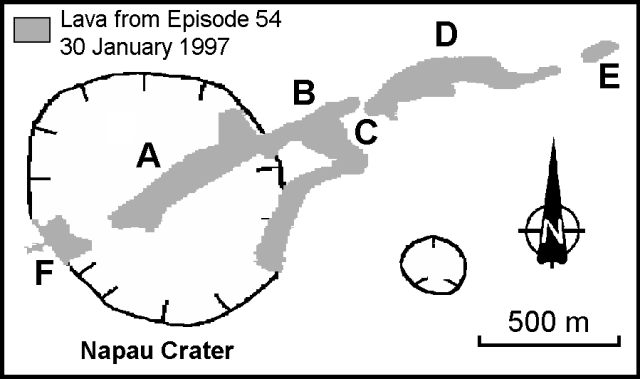 |
Figure 104. Map of Episode-54 lava flows, 30 January 1997. Letter indicate fissure locations. Courtesy of the Hawaiian Volcano Observatory, USGS. |
In total, six fissures emitted more than 300,000 m3 of lava within 24 hours, covering ~258,700 m2 of mostly unvegetated land. A series of intense seismic tremors preceded the eruption, the largest of which were felt at the summit and measured M 3.3 at 2336 on 28 January and 0300 and 0710 on 29 January. More than 30,000 shallow long-period summit earthquakes (high of 5,400 on 2 February) and over 3,000 shallow east rift events were counted during the eruption. Harmonic tremor was recorded near the eruption site for ~7.5 hours and was accompanied by summit deflation (17 µrads). Deflation throughout the eruptive episode totaled ~30 µrads.
Following the eruption, activity at the Pu`u `O`o cinder cone paused. The summit and west side of the cone were removed by collapse, the lava lake drained, and the crater floor dropped an estimated 100 m to a depth of ~250 m below the crater rim (~60 m below the pre-1983 surface). The collapse generated a red dust plume ~800 m high. Lava stopped flowing through the lava tube down-slope from the vent, and the ocean entry produced only intermittent steam plumes.
Kīlauea is one of five coalescing volcanoes that comprise the island of Hawaii. Historically its eruptions originate primarily from the summit caldera or along one of the lengthy E and SW rift zones that extend from the caldera to the sea (figure 105). The latest Kīlauea eruption began in January 1983 along the east rift zone. The eruption's early phases, or episodes, occurred along a portion of the rift zone that extend from Napau Crater on the uprift end to ~8 km E on the downrift end. Activity eventually centered on what was later named Pu'u' O'o.
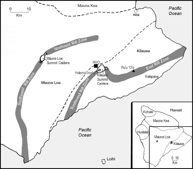 |
Figure 105. Map of the southeastern part of the island of Hawaii and adjacent offshore, showing the principal features of Kīlauea. Modified from Tilling and others, 1987. |
Between July 1986 and January 1992, the Kupianaha lava lake was active ~3 km NE (downrift) of Pu`u `O`o (figure 103). It was during this period that the town of Kalapana and a majority of the 181 homes lost were destroyed. In December 1991, one month prior to the shut down of Kupianaha, eruptive activity returned to Pu`u `O`o. Activity had remained there until this latest episode (episode 54). More than 1 km3 of lava has erupted during the 14 years of activity (January 1983 - January 1997).
Reference. Tilling, R.I., Heliker, C., and Wright, T.L., 1987, Eruptions of Hawaiian volcanoes: past, present, and future: U.S. Geological Survey series of general-interest publications, 54 p.
Geological Summary. Kilauea overlaps the E flank of the massive Mauna Loa shield volcano in the island of Hawaii. Eruptions are prominent in Polynesian legends; written documentation since 1820 records frequent summit and flank lava flow eruptions interspersed with periods of long-term lava lake activity at Halemaumau crater in the summit caldera until 1924. The 3 x 5 km caldera was formed in several stages about 1,500 years ago and during the 18th century; eruptions have also originated from the lengthy East and Southwest rift zones, which extend to the ocean in both directions. About 90% of the surface of the basaltic shield volcano is formed of lava flows less than about 1,100 years old; 70% of the surface is younger than 600 years. The long-term eruption from the East rift zone between 1983 and 2018 produced lava flows covering more than 100 km2, destroyed hundreds of houses, and added new coastline.
Information Contacts: Hawaiian Volcano Observatory (HVO), U.S. Geological Survey, PO Box 51, Hawaii National Park, HI 96718, USA (URL: http://www.soest.hawaii.edu/hvo/).