Report on Kilauea (United States) — February 1997

Bulletin of the Global Volcanism Network, vol. 22, no. 2 (February 1997)
Managing Editor: Richard Wunderman.
Kilauea (United States) Lava returns to Pu`u `O`o
Please cite this report as:
Global Volcanism Program, 1997. Report on Kilauea (United States) (Wunderman, R., ed.). Bulletin of the Global Volcanism Network, 22:2. Smithsonian Institution. https://doi.org/10.5479/si.GVP.BGVN199702-332010
Kilauea
United States
19.421°N, 155.287°W; summit elev. 1222 m
All times are local (unless otherwise noted)
Kīlauea remained quiet for three weeks following the pause that began on 31 January and the subsequent collapse of the summit of Pu`u `O`o (figures 106 and 107). At 0740 on 24 February, a helicopter pilot reported fresh lava in the Pu`u `O`o crater. USGS scientists noted that the new lava pond was positioned ~190-200 m below the crater's N rim, an elevation only slightly higher than the crater floor during the pause in activity and substantially below the 80-m depth that characterized the pond prior to the pause.
 |
Figure 106. Oblique aerial view of Pu`u `O`o looking SW before the late-January 1997 (episode 54) summit collapse (date uncertain). Photographer unknown; courtesy of Richard Fiske, Smithsonian Institution. |
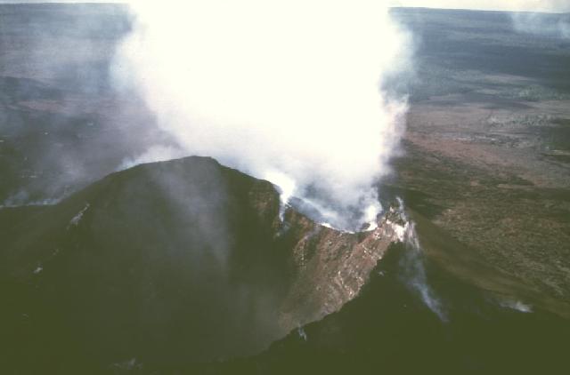 |
Figure 107. Oblique aerial view of Pu`u `O`o looking SW taken shortly after the late January 1997 summit collapse. Photo by G. Brad Lewis; courtesy of Jane Takahashi, USGS. |
Although the crust of the pond was overturning locally and molten lava sloshed through small holes, overall the activity appeared relatively sluggish compared to the vigorous, sloshing pond seen in the past. Similarly, fume at Pu`u `O`o emanated from the E wall of the cone but was minimal compared to pre-30 January levels. There has been no lava visible in the tubes on the flow field since their draining on 30 January. The resupply of magma into the crater occurred without the heightened seismic tremor that marks substantial movement of magma through the rift zone.
Since the pause in activity began on 31 January, the summit inflated 21 µrad. This inflation followed the 30 µrad of deflation that was observed during the short-lived Episode 54 eruption (BGVN 20:01). With minor exceptions, very low tremor was detected at station STC beginning at 0701 on 24 February and continuing at least through 10 March. Shallow, long-period summit earthquakes numbered between 2,000 and 4,000 events/day between 11 and 16 February, but had decreased to ~200 events/day by the end of February.
Eruptive history. Between July 1986 and January 1992, the Kupaianaha lava lake was active ~3 km NE (downrift) of Pu`u `O`o. It was during this period that the town of Kalapana and a majority of the 181 homes lost were destroyed. In December 1991, one month prior to the shutdown of Kupaianaha, eruptive activity returned to Pu`u `O`o. More than 1 km3 of lava has erupted during the 14 years of activity (January 1983-January 1997).
Kīlauea is one of five coalescing volcanoes that comprise the island of Hawaii. Historically its eruptions originate primarily from the summit caldera or along one of the lengthy E and SW rift zones that extend from the caldera to the sea. The latest Kīlauea eruption began in January 1983 along the east rift zone. The eruption's early phases, or episodes, occurred along a portion of the rift zone that extends from Napau Crater on the uprift (towards the summit) end to ~8 km E on the downrift end (towards the sea). Activity eventually centered on the area and crater that was later named Pu`u `O`o.
Geological Summary. Kilauea overlaps the E flank of the massive Mauna Loa shield volcano in the island of Hawaii. Eruptions are prominent in Polynesian legends; written documentation since 1820 records frequent summit and flank lava flow eruptions interspersed with periods of long-term lava lake activity at Halemaumau crater in the summit caldera until 1924. The 3 x 5 km caldera was formed in several stages about 1,500 years ago and during the 18th century; eruptions have also originated from the lengthy East and Southwest rift zones, which extend to the ocean in both directions. About 90% of the surface of the basaltic shield volcano is formed of lava flows less than about 1,100 years old; 70% of the surface is younger than 600 years. The long-term eruption from the East rift zone between 1983 and 2018 produced lava flows covering more than 100 km2, destroyed hundreds of houses, and added new coastline.
Information Contacts: Hawaiian Volcano Observatory (HVO), U.S. Geological Survey, PO Box 51, Hawaii National Park, HI 96718, USA (URL: http://www.soest.hawaii.edu/hvo/); Richard S. Fiske, Smithsonian Institution, NHB MRC 119, Washington, DC 20560 USA.