Report on Arenal (Costa Rica) — March 1997

Bulletin of the Global Volcanism Network, vol. 22, no. 3 (March 1997)
Managing Editor: Richard Wunderman.
Arenal (Costa Rica) Explosions diminished in January but continued through March
Please cite this report as:
Global Volcanism Program, 1997. Report on Arenal (Costa Rica) (Wunderman, R., ed.). Bulletin of the Global Volcanism Network, 22:3. Smithsonian Institution. https://doi.org/10.5479/si.GVP.BGVN199703-345033
Arenal
Costa Rica
10.463°N, 84.703°W; summit elev. 1670 m
All times are local (unless otherwise noted)
During January explosive activity diminished with respect to December 1996 in terms of both the number of eruptions and the quantity of ejected tephra. A S-flank avalanche on 1 January descended to ~1,000 m elevation. On the night of 14 January, a NE-flank pyroclastic flow traveled down to 800 m elevation, scalding vegetation. During February eruptive activity dropped yet lower, and in March, lower still. Despite these decreases, an incandescent avalanche was noted on 27 February at 1600. In addition, during the last week of that month the number of eruptions increased. March ash columns rose <1 km above Crater C. Crater D remained fumarolically active.
During January and February the lava flow on the N flank became active at 950 m elevation. During March, the N-flank flow maintained activity down to 800 m elevation and a new flow began, its path following the previous flow's channel and its front reaching 1,300 m elevation. Cold rock avalanches took place down local drainages (e.g. Calle de Arenas, Gillermina, and Rio Caliente).
Tremor duration peaked in April and June 1996 at around 400 hours/month; thereafter tremor typically remained at ~200-300 hours/month (figure 81). The number of earthquakes peaked in middle to late 1996 (figure 81). Surveys of the distance array revealed that between November 1996 and January 1997 the relative positions of survey stations contracted by an average of 4-5 ppm/month. In March it was reported that the average contraction seen in recent years (~27 ppm) continued along the radial lines on the volcano's W, SW, and S flanks. A dry-tilt station at the base of the volcano typically has small measured tilts amounting to 7-10 µrad/year.
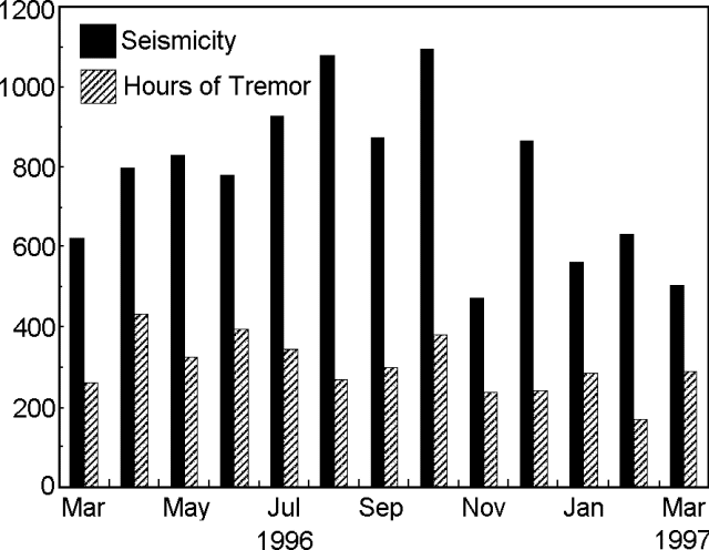 |
Figure 81. Arenal seismicity and tremor recorded during March 1996 through March 1997 (registered at station "VACR," 2.7 km NE of the main crater). Courtesy of OVSICORI-UNA. |
The vegetation that had begun to regrow on the NE, E, and SE flanks continued to be affected by acid rain. Some species displayed burns on the edges and tops of leaves, while others showed signs of discolored leaves.
Geological Summary. Conical Volcán Arenal is the youngest stratovolcano in Costa Rica and one of its most active. The 1670-m-high andesitic volcano towers above the eastern shores of Lake Arenal, which has been enlarged by a hydroelectric project. Arenal lies along a volcanic chain that has migrated to the NW from the late-Pleistocene Los Perdidos lava domes through the Pleistocene-to-Holocene Chato volcano, which contains a 500-m-wide, lake-filled summit crater. The earliest known eruptions of Arenal took place about 7000 years ago, and it was active concurrently with Cerro Chato until the activity of Chato ended about 3500 years ago. Growth of Arenal has been characterized by periodic major explosive eruptions at several-hundred-year intervals and periods of lava effusion that armor the cone. An eruptive period that began with a major explosive eruption in 1968 ended in December 2010; continuous explosive activity accompanied by slow lava effusion and the occasional emission of pyroclastic flows characterized the eruption from vents at the summit and on the upper western flank.
Information Contacts: E. Fernández, E. Duarte, V. Barboza, R. Van der Laat, E. Hernandez, M. Martinez, and R. Sáenz, Observatorio Vulcanológico y Sismológico de Costa Rica, Universidad Nacional (OVSICORI-UNA), Apartado 86, 3000 Heredia, Costa Rica.