Report on Kilauea (United States) — April 1997

Bulletin of the Global Volcanism Network, vol. 22, no. 4 (April 1997)
Managing Editor: Richard Wunderman.
Kilauea (United States) Lava issuing from three sites; Pu`u `O`o lava lake 20 m from W crater rim
Please cite this report as:
Global Volcanism Program, 1997. Report on Kilauea (United States) (Wunderman, R., ed.). Bulletin of the Global Volcanism Network, 22:4. Smithsonian Institution. https://doi.org/10.5479/si.GVP.BGVN199704-332010
Kilauea
United States
19.421°N, 155.287°W; summit elev. 1222 m
All times are local (unless otherwise noted)
Between 8 and 21 April, lava continued to issue in a steady stream from a vent on the W flank of Pu`u `O`o that began erupting on 28 March 1997 (BGVN 22:03). This vent formed during episode-51 vent and sits on a broad shield, also constructed during that episode. The 8-21 April flows mainly advanced S and either remained at the surface as sluggish moving lobes or collected in terraced pools and pits that fed into pre-existing tubes. On 13 April, a spatter cone began to build and by 21 April had reached a height of 15 m above the shield (figure 108).
By 15 April, flows emitted at elevations of ~685-705 had ceased to spread. A flow emitted near 685 m stagnated within 1 km of a steep escarpment (pali) that slopes downward to the coast.
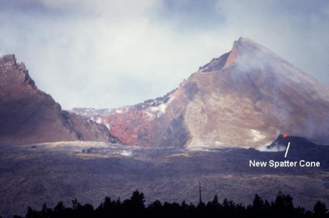 |
Figure 108. Photograph of the W flank of Pu`u `O`o showing the breached crater rim and the new spatter cone, 28 April 1997. Courtesy of Steve O'Meara. |
On 17 April, lava issued from the S flank of Pu`u `O`o 270 m downslope from the active spatter cone. This lava flowed in a channel to the SE; advancing at 1 m/minute, it became 3 km long flowing as pahoehoe upslope and aa downslope. This lava's source remained ambiguous; magma at the nearby spatter cone could have traveled to the new discharge point, or it may have traveled from a deeper origin beneath the Pu`u `O`o area.
Between 22 April and 5 May lava issued from three sites: 1) a sluggish spatter cone within the Pu`u `O`o crater; 2) a more robust spatter cone on the SW flank of the Pu`u `O`o cone (figure 108); and 3) an uplifted mound of lava and tephra on the S flank Pu`u `O`o. The first site discharged pahoehoe flows onto the crater floor. Also, the level of the lava lake in the Pu`u `O`o crater was within 20 m of the low point on the W rim. Although the previous low point on the crater rim was the N spillway, since the 30 January collapse (BGVN 22:01) the W rim has remained the low point (figure 108).
Pahoehoe and aa lava flows from the latter two sites continued to mantle an area within 2 km of Pu`u `O`o. The second site, the spatter cone on the SW flank, issued low-level fountains and draped enough thick sheets of molten lava onto the cone to generate small flows that oozed outward. Periodically, this fountaining became more vigorous than typically seen. Spectacular footage of this fountaining appeared on television newscasts; unfortunately, in some cases the fountaining was incorrectly described as marking a fundamental change in Kīlauea's volcanic activity. Both fountaining and lava flows are characteristic of this particular cone.
The third site, informally called "the uplift" by HVO, formed early in episode 55 (BGVN 22:04) when crusted lava flows were pressed against the flank of Pu`u `O`o and pushed a large wad of tephra upward by 3-4 m. A near-constant stream of lava issued from the uplift; it passed onto the flow field and in many cases it commonly ponded behind its own flow front to form broad pools. Once ponded, the lava generally drained SE forming a complex field of aa lava.
Shallow, long-period summit earthquakes peaked during and shortly after the episode-54 eruption on 30 January (BGVN 22:01) and have since continued to decrease (figure 109). Between 8 April and 5 May, eruption tremor along the E rift zone had amplitudes between background and 3x background. For example, at 0346 on April 16, tremor amplitudes decreased to background levels for over an hour. At about 1900 on 24 April, there were bursts of high tremor that lasted nearly six hours. Around 1700 on 25 April tremor amplitudes dropped to very low levels for several hours. Continuous high tremor was recorded at about 0100 on 28 April, and by about 0001 on 3 May, tremor had dropped to near background levels for ~5 hours.
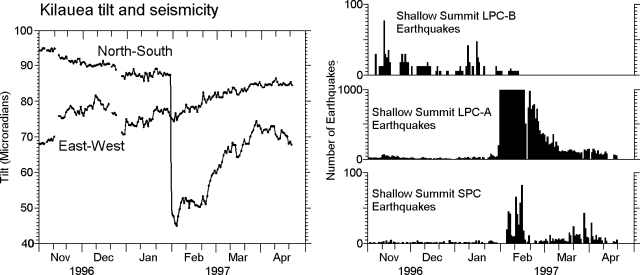 |
Figure 109. Kīlauea summit tilt and seismicity recorded from 1 November 1996 to 21 April 1997. The larger tick marks on the horizontal scale represent monthly intervals and the smaller tick marks represent 10-day intervals. The tilt plot is made of wet-tilt readings taken from the Uwekahuna vault, located across Crater Rim Drive from HVO. Both LPC-A and LPC-B earthquakes are from shallow (0-5 km) sources and have frequencies of 3-5 Hz and 1-3 Hz, respectively. Courtesy of HVO. |
Thirteen episodes of deep tremor occurred from the usual source to the SW. Amplitudes ranged from very low to very high. The two largest tremors occurred during 0400-0448 on 24 April and 1543-1631 on 25 April.
Kīlauea is one of five coalescing volcanoes that comprise the island of Hawaii. Historically its eruptions originate primarily from the summit caldera or along one of the lengthy E and SW rift zones that extend from the summit caldera to the sea. This latest Kīlauea eruption began in January 1983 along the E rift zone. The eruption's early phases, or episodes, occurred along a portion of the rift zone that extends from Napau Crater on the uprift (towards the summit) end to ~8 km E on the downrift (towards the sea) end. Activity eventually centered on what was later named Pu`u `O`o. Between January 1983 and December 1996, erupted lava totaled ~1.45 km3.
Geological Summary. Kilauea overlaps the E flank of the massive Mauna Loa shield volcano in the island of Hawaii. Eruptions are prominent in Polynesian legends; written documentation since 1820 records frequent summit and flank lava flow eruptions interspersed with periods of long-term lava lake activity at Halemaumau crater in the summit caldera until 1924. The 3 x 5 km caldera was formed in several stages about 1,500 years ago and during the 18th century; eruptions have also originated from the lengthy East and Southwest rift zones, which extend to the ocean in both directions. About 90% of the surface of the basaltic shield volcano is formed of lava flows less than about 1,100 years old; 70% of the surface is younger than 600 years. The long-term eruption from the East rift zone between 1983 and 2018 produced lava flows covering more than 100 km2, destroyed hundreds of houses, and added new coastline.
Information Contacts: Hawaiian Volcano Observatory (HVO), U.S. Geological Survey, PO Box 51, Hawaii National Park, HI 96718, USA (URL: https://volcanoes.usgs.gov/observatories/hvo/); Steve O'Meara, PO Box 218, Volcano, HI 96785, USA.