Report on Soufriere Hills (United Kingdom) — April 1997

Bulletin of the Global Volcanism Network, vol. 22, no. 4 (April 1997)
Managing Editor: Richard Wunderman.
Soufriere Hills (United Kingdom) Pyroclastic flows over Galway's Wall reach 500 m from the shore
Please cite this report as:
Global Volcanism Program, 1997. Report on Soufriere Hills (United Kingdom) (Wunderman, R., ed.). Bulletin of the Global Volcanism Network, 22:4. Smithsonian Institution. https://doi.org/10.5479/si.GVP.BGVN199704-360050
Soufriere Hills
United Kingdom
16.72°N, 62.18°W; summit elev. 915 m
All times are local (unless otherwise noted)
The following summarizes the visual observations of Stephen O'Meara on 2 April, NOAA/NESDIS satellite observation reports for April, and the weekly Scientific Reports of the Montserrat Volcano Observatory for the period 6 April-10 May 1997. For a map showing the locations of the places mentioned in this report see this BGVN 22:02. An article on the ongoing activity in Montserrat was published in April on Science magazine.
Visual observations. On 2 April O'Meara flew over Montserrat in a small chartered aircraft at an altitude of ~ 3 km. As he approached from the NE around 1050, with good views of the new delta (figures 20 and 21), the volcano was sending light-gray ash-and-steam clouds up to 4 km. Light-brown material covered much of the pyroclastic deposits in the Tar River Valley, while the delta itself retained a weak mantle of grayish ash. Light veils of ash originating from near Farrell's Wall fell to the N, discoloring a kilometer-long channel. Despite ash and clouds covering most of the summit (except for the E section of the dome), boulders could be seen falling down the NE, E, and SE sides, leaving trails of grayish dust.
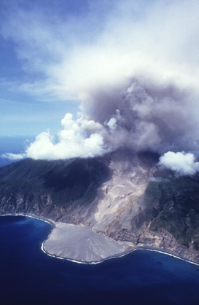 |
Figure 20. View of Soufriere Hills from ENE of the Tar River fan and delta, 2 April 1997. Courtesy of S. O'Meara. |
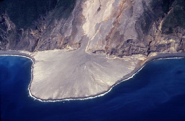 |
Figure 21. Closer view of the delta at Soufriere Hills volcano, 2 April 1997. Courtesy of S. O'Meara. |
A reddish-gray ash that obscured about two-thirds of SW Montserrat was slowly blown toward Plymouth. By the time the aircraft started circling the island again, activity had picked up substantially. A vent on the E side of the dome shot tall columns of ash and steam at a 45° angle to the N, and another vent in the direction of Galway's Wall sent a similarly angled plume of ash and steam to the SW. Within 10 minutes a pyroclastic flow originating in the breach at Galway's Wall went down the White River valley. The comparatively slow moving flow had a curved front trailed by tall convecting ash clouds.
On 6 April MVO reported that coarse rockfall debris had completely filled the chute carved by pyroclastic flows during the Easter collapse. The debris resembled a talus slope ~100 m wide and dipping at 50°. In the center of the scarp between the two peaks, observers saw vigorous degassing and milky, ash-laden steam jets.
A survey of the dome on the same day using both GPS and laser range finding binocular showed that the steep headwall representing the active face of the new lobe was then 100 m high, 150 wide, and dipping 60° (i.e. 10 m higher and 30 m wider, but 20° less steep than on 3 April). In a 3-day period the dome's elevation decreased from 968 m to 950 m and at the headwall the dome had also advanced S by about 20 m toward the top of the chute. In contrast, the N peak of the January dome remained at ~965 m elevation, but it appeared more fractured.
A dome collapse on 11 April sent pyroclastic flows ~500 m farther than any previous flows down the White River valley on the volcano's S flank. The flows stopped ~500 m before reaching the seashore at O'Garra's. The deposits in the valley completely buried the Great Alp Falls. Two distinct flow paths developed in the area around the Galway's Soufriere: 1) a main channel in the White River valley itself, and 2) a path over flat ground W of the main valley and then back into the main valley at a point half way along it. In the upper half of the valley surge clouds covered the topography with deposits.
Observations after 11 April revealed that collapses had eaten away another 100 m of pre-September material on the dome's SW side. The lobe built up again, rapidly replacing the material lost.
Satellite imagery on 12 April indicated a low-level (3 km) ash plume reaching as far as 75 km W of the volcano. Maximum width of the visible plume was 15 km at 40 km from the summit. The day after the plume was still extended 95 km WNW from the volcano. A maximum width of 25 km was measured at 75 km from the summit.
A GPS/laser binocular survey conducted on 15 April showed that the S dome's summit, then at 947 m, continued to slowly decrease in elevation. The maximum size of the lobe was calculated at ~ 0.9 x 10⁶ m3, but no change was detected for the N summit. The most noticeable change in the S region was an increase in the width of the lobe to ~180 m. Most of this expansion had occurred on its W side, and fresh material was encroaching on the remains of the September scar. To the E, the edge of the lobe was now against the Easter collapse scar. Shortly after 15 April the smooth surface of the lobe became increasingly fractured, allowing gas to be emitted from it. Gas and ashy steam was also emitted from the saddle between the dome's summits. Until the end of April the chute over the Galway's Wall continued to widen and fill slowly. The material eroded from the base of the chute by the 11 April collapse was being replaced by short-runout rockfalls and small pyroclastic flows. The soufriere area also continued to be filled by pyroclastic-flow deposits that didn't progress much farther.
Volume estimates in the White River area showed that that the rockfall and pyroclastic-flow activity had deposited 2.3 x 10⁶ m3 of material on 2 April and 2.1 x 10⁶ m3 more by 15 April (values given as Dense Rock Equivalents). These values have helped to constrain the magma extrusion rate at 4.6 m3 /s after the 11 April collapse, in agreement with other field observations.
Ash clouds from pyroclastic flows and rockfalls were detected both in visible and infrared imagery from 24 to 27 April, drifting NW and WSW at ~1 km altitude.
During brief breaks in the weather on 2, 3 and 5 May there was evidence of continued pyroclastic flows and dome growth above Galway's Wall, S of the dome. Most of the dome was visible from the Tar River Estate House on 8 May. Rockfalls were heard from the S side of the Tar River valley, and several large blocks bounced toward Perches Mountain.
No major changes were seen on the E face of the dome during the entire observation period. Several fumaroles were present but only very small rockfalls were noted from the N and E flanks of the dome.
Seismicity. Seismic activity was low until the dome collapse on 11 April. The collapse began with sustained low-amplitude signals. Two pulses of high-intensity activity were recorded at 1107 and 1155, respectively; the second one lasted 15 minutes. A short, high-amplitude signal was recorded as a pyroclastic flow traveled down the lower reaches of the White River valley. Fifteen hours after the end of the pyroclastic-flow activity a short-lived hybrid earthquake swarm took place. During 23-26 April, rockfall activity reached the highest event counts recorded since the beginning of the year. The largest signals were associated with small pyroclastic flows over the Galway's Wall. For the remainder of the month most of the seismicity dropped to a low level, dominated by rockfalls and long-period earthquakes. The number of long-period earthquakes remained high, though, and on a daily basis 40 to 100% of them triggered rockfalls.
A swarm of 28 shallow (2.4-3.6 km below the crater) volcano-tectonic earthquakes occurred on 7-8 May. During the swarm, the level of rockfall and long-period earthquake activity dropped, only to rise to previous levels when the swarm ended. This anti-correlation pattern between hybrid or volcano-tectonic swarms and rockfalls was observed many times before at this volcano, but had been absent since the explosion in September 1996.
Ground deformation. Survey measurements of the W triangle (Lower Amersham Upper Amersham Chance's Peak) continued to show a very slow shortening of the slant distances. There was indication of very slow subsidence of the two target sites relative to the instrument site at Lower Amersham. This trend was also detected during earlier occupations and seemed to reflect the removal of magma at depth below the volcano.
A long GPS occupation of the sites at Harris Lookout (M18) and the site on the crater rim above Farrell's Yard (FT3) was performed on 6 April. The recent outward movement of the FT3 site (BGVN 22:03) away from the dome appeared to have stopped. However an occupation of the Long Ground-Whites-M18 and Harris Lookout-Windy Hill-Farrell's triangles on 16 April using both the GPS and EDM techniques detected slow movement of the Farrell's site away from the crater toward the NNW. The baseline to Harris had shortened by 4 cm since last June. Further occupations at sites on the crater wall close to the dome with a fixed point at M18 Harris Lookout recorded significant movement of the crater rim close to the lava dome complex. These movements, radially outward from the dome, diminished with distance.
An EDM occupation of the N triangle (Windy Hill Farrell's St. George's Hill) on 15 April showed a 40-mm shortening of the Windy Hill Farrell's slant distance since 2 April. This apparent major change, however, was likely affected by atmospheric conditions. A subsequent occupation on 18 April indicated that the Windy Hill Farrell's slant distance had increased by 22 mm in three days. Later occupations during this report period confirmed slow continuous outward and downward movement of the Farrell's target.
Measurements of the cracks on Chance's Peak and on the E side of the Galway's Wall were carried out on 28 April and 3 May, respectively. The Chance's Peak crack recorded 6 mm of extension and 7 mm of dextral shear since 6 April. The crack on the E side of Galway's Wall opened a few millimeters and underwent a total 25 mm of sinistral shear since late March. These measurements suggested that the area between the cracks, which contains the remains of Galways, wall was moving slowly to the SSW, away from the dome.
COSPEC and other measurements. SO2 values recorded on 7 and 11 April were 223 and 1524 t/d, respectively. The latter value, measured immediately after the collapse over the Galway's Wall, was one of the highest ever measured at the Soufriere Hills Volcano. Results from SO2 diffusion tubes collected on 23 March and 6 April (table 17) showed a return to the levels of the past few months, within the recommended limits for occupation or habitation in these areas. The Whites Landfill site on the NE side of the volcano had no detectable sulfur dioxide.
Table 17. Sulfur dioxide diffusion tube results at Soufriere Hills for 23 March and 6 April 1997. Concentrations are in ppb.
| Location | 23 Mar 1997 | 06 Apr 1997 |
| Upper Amersham | 45.10 | 31.05 |
| Lower Amersham | 17.70 | 11.90 |
| White Landfill | 0.00 | 1.4 |
| Police HQ, Plymouth | 8.05 | 5.1 |
| Weekes | 0.00 | 0.00 |
| Control | 0.00 | 0.00 |
Some analyses of rain water samples collected at various locations from 31 March to 11 May appear in table 18. The rainwater continues to be highly acidic and certain anions are present in high concentrations, but well within World Health Organization guidelines.
Table 18. Rain and surface water geochemistry at Soufriere Hills for 31 March, 12 and 29 April, and 11 May 1997. Courtesy of MVO.
| Date | Location | pH | Conductivity (mS/cm) | Total Dissolved Solids (g/l) | Sulfates (mg/l) | Chlorides (mg/l) | Fluorides (mg/l) |
| 31 Mar 1997 | Upper Amersham | -- | 1.566 | 0.784 | 39 | 16.2 | 1.5 |
| 31 Mar 1997 | Lower Amersham | -- | 1.394 | 0.698 | 50 | 158 | 1.4 |
| 31 Mar 1997 | Police HQ, Plymouth | -- | 1.553 | 0.727 | 20 | 16.6 | >1.5 |
| 31 Mar 1997 | Weekes | -- | 0.058 | 0.028 | -- | 10.3 | 0.2 |
| 12 Apr 1997 | Upper Amersham | -- | 0.235 | 0.117 | 20 | 135.5 | 1.4 |
| 12 Apr 1997 | Lower Amersham | -- | 0.300 | 0.150 | 32 | 64.0 | >1.5 |
| 12 Apr 1997 | Police HQ, Plymouth | -- | 0.243 | 0.121 | -- | 28.5 | >1.5 |
| 12 Apr 1997 | Weekes | -- | 0.112 | 0.055 | 3 | 20.0 | 0.55 |
| 29 Apr 1997 | Upper Amersham | 2.60 | 1.902 | 0.953 | 0.60 | -- | -- |
| 29 Apr 1997 | Lower Amersham | 2.90 | 1.166 | 0.584 | >1.5 | -- | -- |
| 29 Apr 1997 | Police HQ, Plymouth | 3.26 | 0.622 | 0.311 | 1.25 | -- | -- |
| 29 Apr 1997 | Weekes | 5.21 | 0.223 | 0.111 | 1.20 | 54 | 8 |
| 11 May 1997 | Upper Amersham | 2.69 | 1.525 | 0.764 | 0.85 | 166 | 37 |
| 11 May 1997 | Police HQ, Plymouth | 2.98 | -- | -- | -- | -- | -- |
| 11 May 1997 | Weekes | 5.56 | 0.051 | 0.025 | 0.25 | 11.8 | 3 |
| 11 May 1997 | Trials overflow | 7.78 | 0.776 | 0.388 | 0.4 | 103 | 38 |
Further Reference. Montserrat Volcano Observatory Team, 1997, The ongoing eruption in Montserrat: Science, v. 276 (5311), p. 371.
Geological Summary. The complex, dominantly andesitic Soufrière Hills volcano occupies the southern half of the island of Montserrat. The summit area consists primarily of a series of lava domes emplaced along an ESE-trending zone. The volcano is flanked by Pleistocene complexes to the north and south. English's Crater, a 1-km-wide crater breached widely to the east by edifice collapse, was formed about 2000 years ago as a result of the youngest of several collapse events producing submarine debris-avalanche deposits. Block-and-ash flow and surge deposits associated with dome growth predominate in flank deposits, including those from an eruption that likely preceded the 1632 CE settlement of the island, allowing cultivation on recently devegetated land to near the summit. Non-eruptive seismic swarms occurred at 30-year intervals in the 20th century, but no historical eruptions were recorded until 1995. Long-term small-to-moderate ash eruptions beginning in that year were later accompanied by lava-dome growth and pyroclastic flows that forced evacuation of the southern half of the island and ultimately destroyed the capital city of Plymouth, causing major social and economic disruption.
Information Contacts: Montserrat Volcano Observatory (MVO), c/o Chief Minister's Office, PO Box 292, Plymouth, Montserrat (URL: http://www.mvo.ms/); Stephen and Donna O'Meara Nature Stock, PO Box 218, Volcano, HI 96785, USA.