Report on San Cristobal (Nicaragua) — June 1997

Bulletin of the Global Volcanism Network, vol. 22, no. 6 (June 1997)
Managing Editor: Richard Wunderman.
San Cristobal (Nicaragua) Seismicity, thin tephra falls, crop damage, and evacuation plans
Please cite this report as:
Global Volcanism Program, 1997. Report on San Cristobal (Nicaragua) (Wunderman, R., ed.). Bulletin of the Global Volcanism Network, 22:6. Smithsonian Institution. https://doi.org/10.5479/si.GVP.BGVN199706-344020
San Cristobal
Nicaragua
12.702°N, 87.004°W; summit elev. 1745 m
All times are local (unless otherwise noted)
Additional information has come to light regarding the eruption that began on the night of 19-20 May 1997 (BGVN 22:05). On the morning of 20 May, fine ash was found on cars in the town of Chinandega (18 km W of the volcano) and the same day people from Hacienda Las Rojas (~3 km SW of the crater) reported 1 mm of ashfall.
The 20 May explosions sometimes occurred nearly continuously for intervals of a few minutes, and at other times stopped for minutes or even hours. Yet, around that time the amount of ash expelled remained very low. The plumes typically moved to the SW, though on some occasions shifting winds carried them N or NE.
INETER volcanologists who visited Hacienda Las Rojas on 8 May prior to the eruption, noticed that the vegetation had been strongly affected by volcanic gases. As time passed, nearby people feared that continued eruptions would threaten local coffee plantations. Moreover, by an undisclosed date thirteen banana growers in Chinandega estimated damage at 40,000 boxes, a loss with an estimated value of US $160,000.
Small eruptions recurred, though in June the rainy season brought decreased visibility. As a result, both observation points at Casita volcano and San Cristóbal crater were frequently cloud-covered. Although during June ash only fell in small amounts and very near the volcano, starting on 3 July ash accumulated at a village 2 km W of the volcano (Las Rojas) and by an undisclosed time it reached 2-mm thickness. Also, starting on 7 July residents reported new ash in Chinandega, this time in greater amounts and composed of coarser particles than the May ash. The concern at INETER was that these coarser and thicker ashes could indicate the ascent of magma to shallower levels.
To prepare for outbursts of increased intensity the local administration together with the Civil Defense Organization took some preventive measures. Immediately after the 14 May alert information submitted by INETER, they organized meetings with local residents to explain evacuation plans. In Chinandega a meeting was organized that included high-ranking government officials and INETER volcanologists who explained the volcanic risk. Key roads in the populated area near the volcano were repaired to facilitate rapid evacuation if necessary.
Seismic data. The RSAM (Real-time Seismic Amplitude Measurement) index of seismicity was computed from the 10-minute mean of seismic amplitude at station CRIN (figure 3). This station, which lies near Hacienda Las Rojas (3 km SW of the crater) contains an L-4 seismometer and a 60-dB amplifier. The available time series contained occasional artifacts of telemetry or system interruptions. Some RSAM interruptions resulted from low batteries due to clouded skies and ash on solar panels. These artifacts were removed and then the data were filtered with an ~3-hour-long gliding mean that effectively removed the short time-interval maxima. Prior to this processing some maxima had reached 140 RSAM units.
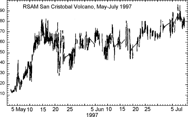 |
Figure 3. RSAM data from San Cristóbal, May-July 1997. Courtesy of Wilfried Strauch, INETER. |
The RSAM index reached a maximum on 14-15 May (figure 2) and remained stable until 23 May. It then declined to a minimum on 26 May. RSAM again reached ~60 at the beginning of June where it remained until early July, when it climbed to a maximum near 95 units.
Geological Summary. The San Cristóbal volcanic complex, consisting of five principal volcanic edifices, forms the NW end of the Marrabios Range. The symmetrical 1745-m-high youngest cone, named San Cristóbal (also known as El Viejo), is Nicaragua's highest volcano and is capped by a 500 x 600 m wide crater. El Chonco, with several flank lava domes, is located 4 km W of San Cristóbal; it and the eroded Moyotepe volcano, 4 km NE of San Cristóbal, are of Pleistocene age. Volcán Casita, containing an elongated summit crater, lies immediately east of San Cristóbal and was the site of a catastrophic landslide and lahar in 1998. The Plio-Pleistocene La Pelona caldera is located at the eastern end of the complex. Historical eruptions from San Cristóbal, consisting of small-to-moderate explosive activity, have been reported since the 16th century. Some other 16th-century eruptions attributed to Casita volcano are uncertain and may pertain to other Marrabios Range volcanoes.
Information Contacts: Wilfried Strauch, Department of Geophysics, and Marta Navarro C., Department of Volcanoes, Instituto Nicaragüense de Estudios Territoriales (INETER), P.O. Box 1761, Managua, Nicaragua.