Report on Whakaari/White Island (New Zealand) — July 1997

Bulletin of the Global Volcanism Network, vol. 22, no. 7 (July 1997)
Managing Editor: Richard Wunderman.
Whakaari/White Island (New Zealand) Surveys on 11 March and 6 May confirm that the deflation trend continues
Please cite this report as:
Global Volcanism Program, 1997. Report on Whakaari/White Island (New Zealand) (Wunderman, R., ed.). Bulletin of the Global Volcanism Network, 22:7. Smithsonian Institution. https://doi.org/10.5479/si.GVP.BGVN199707-241040
Whakaari/White Island
New Zealand
37.52°S, 177.18°E; summit elev. 294 m
All times are local (unless otherwise noted)
Scientists from the Institute of Geological and Nuclear Sciences (IGNS) visited White Island on 11 March and 6 May. Prior to the visits, the 1993-96 inflationary and heating trend had peaked without eruptive activity, thus suggesting a lower probability of a significant eruption in the short-term. However, inflation remained above 1993 levels.
Crater and fumarole observations. The island was visited on 11 March by S. Sherburn who accompanied a UK-based film company. The lake in the 1978/90 Crater complex was emerald green and its level had change little since January (BGVN 22:02). Although some gray slicks on the lake surface were observed, there was no evidence of convection. A noisy fumarole on the N wall was noted.
On 6 May the lake level was lower than on 11 March, and several small banks or islands were emerging from it. Steam in the crater thwarted efforts to observe convection. The lake temperature was 66°C, three degrees cooler than the last measurement obtained on 31 January. Minor collapse of the crater margin continued, especially around the steeper N and NE margins. Both fumarole 13a and the fumarole centered in Donald Mound registered temperatures slightly lower than those previously reported.
Deformation and magnetic surveys. Visitors completed a full survey of the leveling network on the main Crater floor in good conditions. It indicated continued subsidence at an area subsiding since November 1996 (BGVN 21:11) (figure 26). It also revealed that in the center of Donald Mound there was a semi- elongated subsidence zone dropping at a rate of 9 mm/month; this subsidence was first noticed in January 1997 (BGVN 22:01) (figure 27).
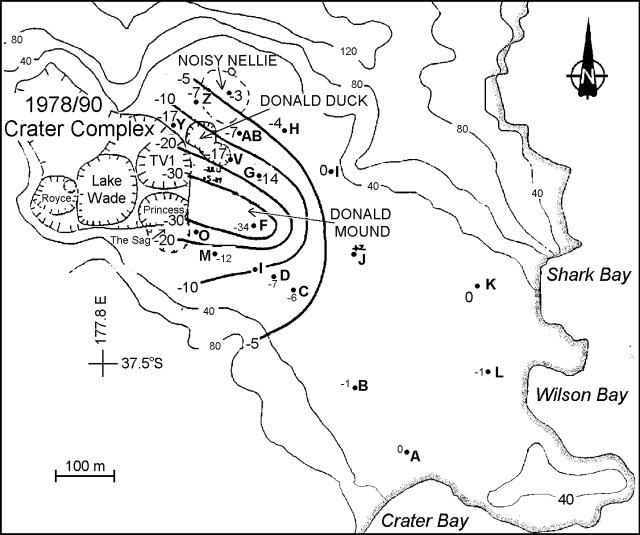 |
Figure 26. Contour plot showing height changes at White Island between 31 January and 6 May. Height changes are in millimeters. Courtesy of B. J. Scott, IGNS. |
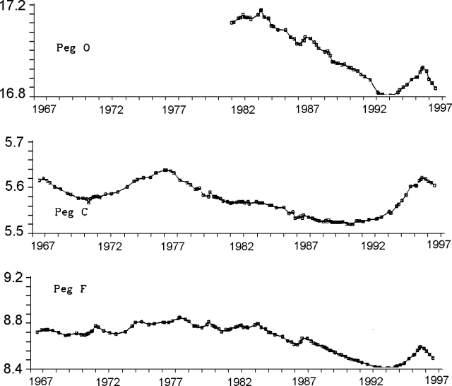 |
Figure 27. Time series plot for White Island showing height of selected pegs. Refer to figure 26 for peg locations. Courtesy of B. J. Scott, IGNS. |
In situ magnetism observed between 31 January and 6 May 1997 showed the smallest rates of change recorded in the last few years and no changes >50 nT. Most sites underwent a small field strength decrease. The only significant increases were on the N side of Donald Mound (a maximum recorded change of +46 nT at site S), indicating continuing shallow (~ 50 m deep) cooling. It was noted that at site S the rate of magnetic change had decreased significantly (0.48 nT/day, compared with 1.41 nT/day during 4 November 1996 to 31 January 1997). The widespread, small decreases could be due to an uncorrected diurnal variation or deep heating. The most recent data on the graph of the cumulative magnetic change at sites G and M (figure 28) may indicate that the trend at site G reversed. Such a reversal would imply heating; however, more time is required to confirm a trend reversal. Overall, the low rates of change in magnetism could indicate that temperature had stabilized and that the current level of surface hydrothermal activity will not greatly change in the short term.
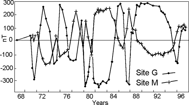 |
Figure 28. Time series plot showing magnetic changes at White Island's pegs G and M. Refer to figure 26 for peg locations. Courtesy of B. J. Scott, IGNS. |
Seismicity. Volcanic tremor had dominated the seismic records since July 1996 when it prevailed at a new background level ~4x higher that the average earlier that year. The ground motion for 1997 (figure 29) showed no diagnostic trend or clearly demonstrative pattern.
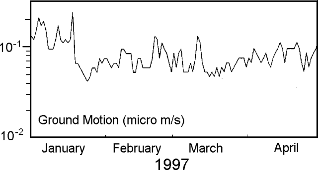 |
Figure 29. Time series plot showing White Island's volcanic tremor for 1997 (logarithm of tremor amplitude versus time). Courtesy of B. J. Scott, IGNS. |
The uninhabited, 2 x 2.4 km White Island emerges at the summit of a 16 x 18 km submarine volcano. The island consists of two overlapping stratovolcanoes; the summit crater appears to be breached to the SE because the shoreline corresponds to the level of several notches in the SE crater wall. Intermittent steam and tephra eruptions have occurred throughout the short historical period, but its activity is also prominent in Maori legends.
Geological Summary. The uninhabited Whakaari/White Island is the 2 x 2.4 km emergent summit of a 16 x 18 km submarine volcano in the Bay of Plenty about 50 km offshore of North Island. The island consists of two overlapping andesitic-to-dacitic stratovolcanoes. The SE side of the crater is open at sea level, with the recent activity centered about 1 km from the shore close to the rear crater wall. Volckner Rocks, sea stacks that are remnants of a lava dome, lie 5 km NW. Descriptions of volcanism since 1826 have included intermittent moderate phreatic, phreatomagmatic, and Strombolian eruptions; activity there also forms a prominent part of Maori legends. The formation of many new vents during the 19th and 20th centuries caused rapid changes in crater floor topography. Collapse of the crater wall in 1914 produced a debris avalanche that buried buildings and workers at a sulfur-mining project. Explosive activity in December 2019 took place while tourists were present, resulting in many fatalities. The official government name Whakaari/White Island is a combination of the full Maori name of Te Puia o Whakaari ("The Dramatic Volcano") and White Island (referencing the constant steam plume) given by Captain James Cook in 1769.
Information Contacts: B.J. Scott, C. Wilson, B.F. Houghton, and I. Nairn, Institute of Geological & Nuclear Sciences (IGNS), Private Bag 2000, Wairakei, New Zealand.