Report on Soufriere Hills (United Kingdom) — July 1997

Bulletin of the Global Volcanism Network, vol. 22, no. 7 (July 1997)
Managing Editor: Richard Wunderman.
Soufriere Hills (United Kingdom) Activity increased to high levels on 31 July
Please cite this report as:
Global Volcanism Program, 1997. Report on Soufriere Hills (United Kingdom) (Wunderman, R., ed.). Bulletin of the Global Volcanism Network, 22:7. Smithsonian Institution. https://doi.org/10.5479/si.GVP.BGVN199707-360050
Soufriere Hills
United Kingdom
16.72°N, 62.18°W; summit elev. 915 m
All times are local (unless otherwise noted)
The following condenses reports from the Montserrat Volcano Observatory (MVO) for July 1997. Activity decreased during the month and the dome appeared to be growing at a lower rate than immediately after the energetic and destructive 25 June pyroclastic flow. Starting on 31 July, however, activity increased.
Visual observations. During 1-5 July several pyroclastic flows traveled down Mosquito, Gages, and Fort Ghauts, the largest ones reaching 3 km downstream. Many of these flows started with resounding explosions and ash columns that rose as high as 11 km at measured rates of 9-17 m/s. Plumes were visible from the Space Shuttle (figure 29).
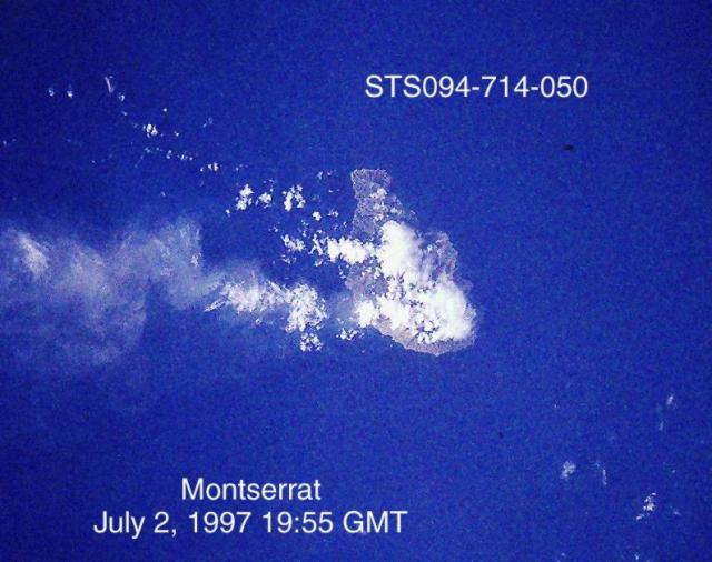 |
Figure 29. Photograph of Montserrat showing a plume from Soufriere Hills volcano taken from the Space Shuttle, 2 July 1997 at 1955 GMT (photo STS094-714-050). North is towards the top; the island measures about 8 x 13 km. Courtesy of NASA. |
The two weeks following 5 July were relatively quiet. During this interval rockfalls traveled as far as 500 m down the W and N faces of the dome. A brief glimpse of the dome on the night of 6 July revealed incandescent rockfalls above Mosquito Ghaut and Gages Valley. A partial view during the morning of 7 July showed a new steep-sided post-25 June dome above Mosquito Ghaut and Gages Valley with a broad, relatively flat summit area.
From 8 to 13 July there were fairly frequent emissions of diluted ash, often coinciding with the peak of the tilt cycle, and at times preceding small pyroclastic flows. The ash columns, reaching heights of ~ 3 km before dissipating, appeared to emanate from the W side of the post-25 June dome above Gages Valley. Theodolite measurements on 13 July gave an altitude of 950 m for the old dome and 941 m for the new growth in the 25 June scar. There was a steep 50-m-high protrusion on the new dome above Gages Valley. On 17 July the high point on the old dome (NE) measured 946 m, and the high point on the post-25 June dome 957 m. The spine above Gages valley observed on 13 July was no longer present.
On 21 July a field party at Trant's probing to a depth of 2 m inside the deposits at the end of the 25 June flow found a temperature of 640°C. A helicopter survey on 24 July showed fresh deposits in all of the ghauts around the volcano except Tuitt's. Another surveillance flight on 26 July indicated that most the rockfall activity was confined to Mosquito Ghaut and Gages Valley on the NE, and to the Galways area to the S. Vigorous steaming was coming from the flank of the dome in the Tar River area.
On 29 July between 0600 and 0830 there was more intense activity with several pulses of pyroclastic flows moving down Gages Valley as far as Gages Lower Soufriere. This activity was not preceded by earthquakes or a perceptible increase in rockfall activity. Other small pyroclastic flows occurred throughout the day.
Despite overcast conditions on 30 July, dilute ash plumes were visible from the Observatory during periods of heightened rockfall activity. A late-evening observation flight revealed that pyroclastic-flow deposits from 29 July extended just below the lower soufriere in Gages Valley. Several small pyroclastic-flow deposits from earlier that day (30 July) were noted on the N flank (top of Tuitts Ghaut) and NE flank (Tar River Valley and Galways area).
After 0300 on 31 July there were several periods of intense volcanic activity. A helicopter inspection showed very few new deposits in Gages valley (as far as Gages village) and some small flow lobes in Tuitt's Ghaut (to ~ 2 km from the dome). Many ash plumes were produced throughout the day and the most vigorously convecting clouds reached altitudes above 5 km. It appeared that most of the ash originated from near the top of Gages wall and was not necessarily associated with pyroclastic flows. The ash clouds drifted to the N and NW in light winds, but later in the day they traveled mostly to the W.
Seismicity. After 25 June swarms of hybrid earthquakes typically changed to tremor before the emission of pyroclastic flows. After 8 July hybrid swarms ceased, leaving seismicity dominated by rockfall signals of steady amplitude. A few long-period and hybrid events were recorded, but such activity remained at a very low level.
The number of rockfalls in the upper parts of Mosquito Ghaut and the Gages valley started increasing after 25 July. However, until 30 July the only other seismic signals recorded were a few long-period events. Starting at about 0300 on 31 July the activity became once again very elevated, peaking between 1230 and 1430, when the new Lees Yard seismometer recorded ~2 hours of nearly maximum amplitude signal. During this interval only one moderate- size pyroclastic flow was observed. Still the seismometers registered a significant increase of long-period earthquakes in addition to high-amplitude tremor that continued for much of the day, associated with ash clouds convecting to 6 km.
During the month several periods of low- to moderate-amplitude tremors appeared on both the St. George's Hill and St. Patrick's seismometer (e.g. 28-30 July); they were caused by heavy rains moving recent deposits. The largest volcano-tectonic events of the month occurred at shallow depths beneath English's crater on 24 July.
Ground deformation and volume measurements. EDM measurements showed that in general the inflation-deflation cycle that began on 22 June continued until 5 July with the same period (8 hours) and amplitude. However, after 25 June the trend showed deflation toward the center of the dome. Prior to 25 June inflation occurred to the N and deflation to the S. A survey of EASTNET stations at Harris, Windy Hill, Whites, and Long Ground on 16 July showed that the line to Whites had shortened by 16 mm since last measured on 24 June and by 31 mm from its long term mean. The line to Long Ground showed continued shortening and the line between Long Ground and Windy Hill showed slight lengthening. All the changes were consistent with their current trends although at slightly higher rates.
During 5-19 July the tilt cycles were characterized by lower amplitudes and longer (30-hour) periods; Chances Peak tiltmeter showed a gradual decrease in the rate of subsidence of the x-axis oriented SW. Superimposed on this trend were periods of cyclical inflation and deflation, often associated with hybrid swarms.
Measurements on the EDM line from Waterworks to Lees Yard on 20 and 27 July showed no major changes, although it had consistently shortened since first measured on 12 July 1997. No significant changes were observed on 26 and 27 July on either the new NW triangle (MVO-Garibaldi Hill-Lees Yard) or on the Waterworks-Lees Yard radial line. Finally, 30 July EDM measurements on the NW triangle confirmed the absence of a consistent trend.
A GPS survey on 5 July allowed an estimate of the total volume of deposits in several areas. The 25- June pyroclastic flow area was estimated at 4.61 x 10⁶ m3 and the volume of the flow that propagated into the Belham Valley was 90 x 103 m3. The combined volume of Mosquito, Paradise, Farms, and Farrell's deposits totalled 9.24 x 10⁶ m3, and the Gages Valley deposit was 3 x 10⁶ m3.
A dome volume of 77 x 106 m3 was calculated based on photographs from 17 July. Cumulative pyroclastic flow deposits were estimated to be 55.05 x 10⁶ m3 (DRE). The previous dome volume estimate on 31 May was 64.6 x 10⁶ m3, and the pyroclastic-flow deposit volume was 43.0 x 10⁶ m3. The average growth rate between 31 May and 17 July was 5.2 m3/s (DRE); visual observations suggested that after 25 June the growth rate was significantly higher.
Environmental monitoring. Rain water and trough water samples were collected from sites around the volcano on 10 and 22 June and 9 July. These values were nearly all within World Health Organization standards for drinking water, but the samples from Upper and Lower Amersham were extremely acidic and had high concentrations of total dissolved solids. All samples collected on 9 July to the N of the volcano had very low pH, probably because of the northerly wind direction on 8 July during heavy rain. Residents in the N of the island reported unusual sulfurous smells and light ashfall at this time.
A miniCOSPEC was used to measure SO2 flux from the volcano (table 23). Fluxes increased before 25 June and remained comparatively high through 24 June. Since 25 June no measurements were possible along the roads of the central corridor or through Plymouth because of the extreme risk in these areas, thus the value for 17 July were measured by static scanning of the plume from Garibaldi Hill an average of 10 scans.
Table 23. Daily average SO2 flux at Soufriere Hills using miniCOSPEC (metric tons/day). Courtesy of MVO.
| Date | SO2 flux (metric tons/day) |
| 10 Jun 1997 | 842 |
| 11 Jun 1997 | 839 |
| 12 Jun 1997 | 363 |
| 14 Jun 1997 | 442 |
| 15 Jun 1997 | 634 |
| 16 Jun 1997 | 409 |
| 17 Jun 1997 | 450 |
| 19 Jun 1997 | 618 |
| 20 Jun 1997 | 1171 |
| 21 Jun 1997 | 921 |
| 22 Jun 1997 | 438 |
| 23 Jun 1997 | 1157 |
| 24 Jun 1997 | 1933 |
| 17 Jul 1997 | 200 |
Workers collecting ash on 9 June found that small accretionary lapilli were common at the Plymouth sites. The same ash fell over a region including Brodericks and Dyers and it was thickest (2.5 mm) at Upper Amersham. On 17-18 June workers found a similar amount of ash had accumulated although in this deposit they recognized a significantly coarse grained component: it reached up to 5 mm in diameter close to the volcano. After a small explosive event on 27 June, coarse lapilli (up to 10 mm in diameter) were collected from Dagenham and Richmond Hill.
Geological Summary. The complex, dominantly andesitic Soufrière Hills volcano occupies the southern half of the island of Montserrat. The summit area consists primarily of a series of lava domes emplaced along an ESE-trending zone. The volcano is flanked by Pleistocene complexes to the north and south. English's Crater, a 1-km-wide crater breached widely to the east by edifice collapse, was formed about 2000 years ago as a result of the youngest of several collapse events producing submarine debris-avalanche deposits. Block-and-ash flow and surge deposits associated with dome growth predominate in flank deposits, including those from an eruption that likely preceded the 1632 CE settlement of the island, allowing cultivation on recently devegetated land to near the summit. Non-eruptive seismic swarms occurred at 30-year intervals in the 20th century, but no historical eruptions were recorded until 1995. Long-term small-to-moderate ash eruptions beginning in that year were later accompanied by lava-dome growth and pyroclastic flows that forced evacuation of the southern half of the island and ultimately destroyed the capital city of Plymouth, causing major social and economic disruption.
Information Contacts: Montserrat Volcano Observatory (MVO), c/o Chief Minister's Office, PO Box 292, Plymouth, Montserrat (URL: http://www.mvo.ms/); NOAA/NESDIS Satellite Analysis Branch (SAB), Room 401, 5200 Auth Road, Camp Spring, MD 20746, USA; Cindy Evans, Space Shuttle Earth Observations Office, Mail Code C102, Lockheed Engineering & Sciences, P.O. Box 58561, Houston, TX 77258 USA.