Report on Ruapehu (New Zealand) — August 1997

Bulletin of the Global Volcanism Network, vol. 22, no. 8 (August 1997)
Managing Editor: Richard Wunderman.
Ruapehu (New Zealand) Elevated seismicity in late July
Please cite this report as:
Global Volcanism Program, 1997. Report on Ruapehu (New Zealand) (Wunderman, R., ed.). Bulletin of the Global Volcanism Network, 22:8. Smithsonian Institution. https://doi.org/10.5479/si.GVP.BGVN199708-241100
Ruapehu
New Zealand
39.28°S, 175.57°E; summit elev. 2797 m
All times are local (unless otherwise noted)
Volcanic tremor recorded during 26-28 July (figure 24) was the first significant seismic activity at Ruapehu since August 1996 (BGVN 21:11). The tremor started gradually at about 0330 on 26 July and increased to a maximum level at 0530. It stayed at that level, more than twice the usual background level, until 1030 on 27 July. A weaker tremor was recorded between 0220 and 0510 on 28 July. Seismicity returned to background levels during the next few days.
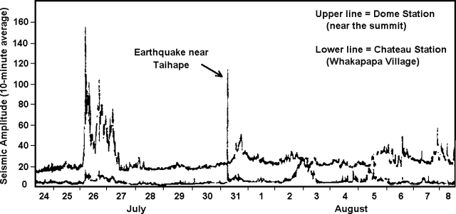 |
Figure 24. Seismic tremor amplitude (10-minute average) recorded at Ruapehu, 24 July-8 August 1997. Ticks along both axes are approximate. Courtesy of IGNS. |
Scientists visited the crater on 30 July and found that the temperature of the water in the crater lake was 64°C, essentially the same temperature as was recorded in mid-June. The lake surface was steaming strongly, and the water was churning and bubbling. Steam vents, recently drowned with the rising lake level, were causing the convection within the lake.
Further enhanced tremor was recorded on 31 July. During 5-8 August volcanic tremor levels fluctuated above typical background values (figure 24). None of the tremor recorded through 8 August was as strong as during 26-27 July. Significant volcanic tremor recommenced again shortly after 0700 on 2 October. Tremor amplitude quickly increased to a level equivalent to that on 25 July and lasted through at least noon. This tremor was similar to that recorded in late July-early August this year, but was weaker than the tremor that preceded the 1996 eruptions.
Geological Summary. Ruapehu, one of New Zealand's most active volcanoes, is a complex stratovolcano constructed during at least four cone-building episodes dating back to about 200,000 years ago. The dominantly andesitic 110 km3 volcanic massif is elongated in a NNE-SSW direction and surrounded by another 100 km3 ring plain of volcaniclastic debris, including the NW-flank Murimoto debris-avalanche deposit. A series of subplinian eruptions took place between about 22,600 and 10,000 years ago, but pyroclastic flows have been infrequent. The broad summait area and flank contain at least six vents active during the Holocene. Frequent mild-to-moderate explosive eruptions have been recorded from the Te Wai a-Moe (Crater Lake) vent, and tephra characteristics suggest that the crater lake may have formed as recently as 3,000 years ago. Lahars resulting from phreatic eruptions at the summit crater lake are a hazard to a ski area on the upper flanks and lower river valleys.
Information Contacts: Brad Scott, Wairakei Research Center, Institute of Geological and Nuclear Sciences (IGNS), Private Bag 2000, Wairakei, New Zealand (URL: https://www.gns.cri.nz/).