Report on Irazu (Costa Rica) — September 1997

Bulletin of the Global Volcanism Network, vol. 22, no. 9 (September 1997)
Managing Editor: Richard Wunderman.
Irazu (Costa Rica) Four-days of earthquakes on nearby fault leave volcano undisturbed
Please cite this report as:
Global Volcanism Program, 1997. Report on Irazu (Costa Rica) (Wunderman, R., ed.). Bulletin of the Global Volcanism Network, 22:9. Smithsonian Institution. https://doi.org/10.5479/si.GVP.BGVN199709-345060
Irazu
Costa Rica
9.979°N, 83.852°W; summit elev. 3436 m
All times are local (unless otherwise noted)
A seismic swarm adjacent to Irazú occurred during 15-18 June (figure 11). During this interval there were 1,311 swarm-related earthquakes, but including other locally detected earthquakes, the total reached 1,550 (figure 11). The swarm's largest events, M 3.0 and 3.3, appeared in the midst of the swarm (at 0305 and 0530 on 16 June). The swarm failed to induce reported morphologic changes at the volcano; nor did it cause significant changes at the tilt network, which included the main crater.
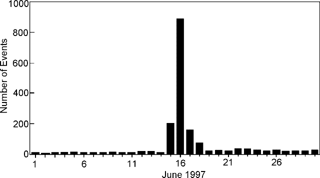 |
Figure 11. Histogram of daily earthquakes registered at Irazú's seismic station "IRZ2," 5 km SW of the active crater, showing the 15-18 June 1997 seismic swarm. Courtesy of OVSICORI-UNA. |
Many earthquakes fell on the Retes fault (figure 12); however, some of the stronger ones were felt near the volcano. Located epicenters chiefly clustered ~2-7 km SSE of the volcano. The earthquakes appeared at depths of 1-8 km, but those well-located were in the 1-4 km range. Epicenters remained confined to a narrow 8-km-long zone trending NW-SE; the similarly trending fault is thought to pass ~4 km SW of Irazú at the point where it intersects Cerro Retes.
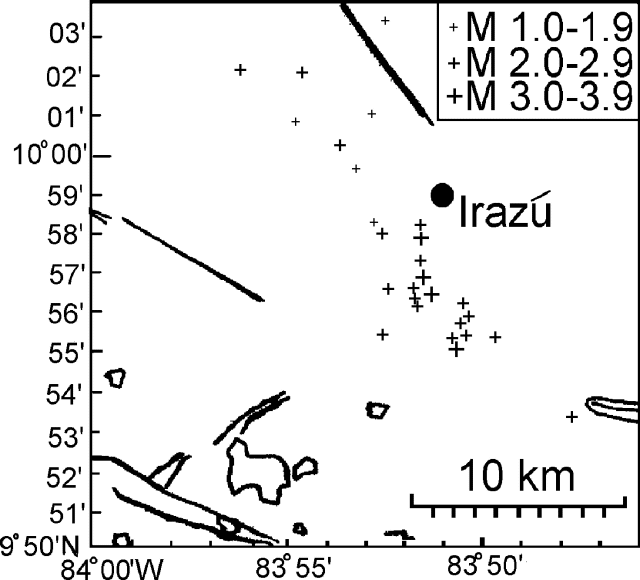 |
Figure 12. Sketch map of epicenters for the 15-18 June seismic event along the Retes fault adjacent Irazú. Heavy lines indicate faults; circled areas indicate lakes. The exact location of Retes fault is undisclosed. Courtesy of OVSICORI-UNA. |
During July there were 205 earthquakes, including two of M 2.1 and 2.6 at depths of 5.8 and 17 km, respectively. During August and September there were 106 and 185 small-magnitude local earthquakes.
Geological Summary. The massive Irazú volcano in Costa Rica, immediately E of the capital city of San José, covers an area of 500 km2 and is vegetated to within a few hundred meters of its broad summit crater complex. At least 10 satellitic cones are located on its S flank. No lava effusion is known since the eruption of the Cervantes lava flows from S-flank vents about 14,000 years ago, and all known Holocene eruptions have been explosive. The focus of eruptions at the summit crater complex has migrated to the W towards the main crater, which contains a small lake. The first well-documented eruption occurred in 1723, and frequent explosive eruptions have occurred since. Ashfall from the last major eruption during 1963-65 caused significant disruption to San José and surrounding areas. Phreatic activity reported in 1994 may have been a landslide event from the fumarolic area on the NW summit (Fallas et al., 2018).
Information Contacts: E. Fernandez, R. Van der Laat, F. de Obaldia, T. Marino, V. Barboza, W. Jimenez, R. Saenz, E. Duarte, M. Martinez, E. Hernandez, and F. Vega, Observatorio Vulcanologico y Sismologico de Costa Rica, Universidad Nacional (OVSICORI-UNA), Apartado 86-3000, Heredia, Costa Rica; G.J. Soto, Oficina de Sismologia y Vulcanologia del Arenal y Miravalles (OSIVAM), Instituto Costarricense de Electricidad (ICE), Apartado 10032-1000, San Jose, Costa Rica.