Report on Bezymianny (Russia) — November 1997
Bulletin of the Global Volcanism Network, vol. 22, no. 11 (November 1997)
Managing Editor: Richard Wunderman.
Bezymianny (Russia) Explosive eruption on 5 December
Please cite this report as:
Global Volcanism Program, 1997. Report on Bezymianny (Russia) (Wunderman, R., ed.). Bulletin of the Global Volcanism Network, 22:11. Smithsonian Institution. https://doi.org/10.5479/si.GVP.BGVN199711-300250
Bezymianny
Russia
55.972°N, 160.595°E; summit elev. 2882 m
All times are local (unless otherwise noted)
An explosive eruption began on 5 December. Seismic and fumarolic activity had mainly been normal since May 1997 (BGVN 22:09). Seismicity was at background level during 13 October-2 November with normal fumarolic activity (plumes 50-100 m tall) observed during 21-26 October. During 3-9 November seismicity increased and plumes up to 1 km high were seen; the plume extended 10-15 km SSE on 8-9 November. Normal low plumes were again seen on 12, 14-15, 18, 27, and 30 November.
A growing hot spot was monitored on satellite images by Alaska Volcano Observatory (AVO) remote sensing specialists during 3-4 December. The hot spot was not accompanied by unusual activity; it was assumed to be related to small debris avalanches at the dome. Visual observations during that period indicated that a fumarolic plume rose 500 m above the volcano and extended 15-20 km SW.
An explosive eruption began at about 0630 on 5 December. No preliminary seismicity was detected; however, the eruption's onset was indicated by an abrupt increase in seismicity. By 0830, the eruption plume reached a height of 6 km and had traveled ~20 km NE. By 1200 observers in the towns of Kozyrevsky and Klyuchi reported an increase in the eruption's intensity; at 1215, the Kamchatka Volcanic Eruption Response Team (KVERT) estimated the plume height at ~9 km dispersing >50 km NE . . . . Seismicity remained elevated until 1400, but eruptive activity declined.
Several volcanic ash advisories were issued to warn aviators about the ash plume during 5-7 December. For example, an advisory at 1015 on 5 December reported an ash plume extending 15 km NE at an altitude of ~6 km. Another advisory cited a GMS infrared image taken at [0932] showing a plume 55 km wide extending NE (figure 4). [Satellite imagery at 1332 showed the plume rising to ~9-10 km; it was 63 km wide and extended 211 km E. Pilot reports later in the day estimated the ash plume at altitudes of ~12-13 km.] . . . .
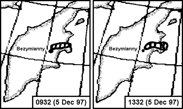 |
Figure 4. [Sketches showing Bezymianny's ash plume on 5 December 1997 at 0932 (2132 GMT on 4 December) and 1332 (0132 GMT) based on GMS infrared satellite imagery. Courtesy of SAB.] |
. . . [Judging from] satellite imagery, activity declined during the night of 5-6 December. At 0800 on 6 December, a small steam plume with little to no ash rose ~3.5-4 km and moved ~20 km NE. By 1030 decreased eruptive activity led KVERT to downgrade the hazard status to yellow (during the eruption it was red). Local seismicity was masked by intense aftershocks following a M 7.8 earthquake off the E coast of Kamchatka during the night of 5-6 December.
On 7 December, a gas-and-steam plume rose 500 m above the volcano and extended as far as 1 km SE. A fumarolic plume on 8-9 December rose 50-100 m and extended SE. By 9 December, the hazard status had returned to green and seismicity was at background. During 15-21 December, the volcano was obscured by clouds but seismicity remained normal. A fumarolic plume on 24 December rose 50-100 m above the volcano.
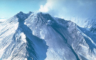
Geological Summary. The modern Bezymianny, much smaller than its massive neighbors Kamen and Kliuchevskoi on the Kamchatka Peninsula, was formed about 4,700 years ago over a late-Pleistocene lava-dome complex and an edifice built about 11,000-7,000 years ago. Three periods of intensified activity have occurred during the past 3,000 years. The latest period, which was preceded by a 1,000-year quiescence, began with the dramatic 1955-56 eruption. This eruption, similar to that of St. Helens in 1980, produced a large open crater that was formed by collapse of the summit and an associated lateral blast. Subsequent episodic but ongoing lava-dome growth, accompanied by intermittent explosive activity and pyroclastic flows, has largely filled the 1956 crater.
Information Contacts: Vladimir Kirianov, Kamchatka Volcanic Eruptions Response Team, IVGG, Piip Blvd, 9 Petropavlovsk-Kamchatskiy, 683006, Russia; Tom Miller, Alaska Volcano Observatory (AVO), a cooperative program of a) U.S. Geological Survey, 4200 University Drive, Anchorage, AK 99508-4667, USA (URL: http://www.avo.alaska.edu/), b) Geophysical Institute, University of Alaska, PO Box 757320, Fairbanks, AK 99775-7320, USA, and c) Alaska Division of Geological & Geophysical Surveys, 794 University Ave., Suite 200, Fairbanks, AK 99709, USA; NOAA/NESDIS Satellite Analysis Branch (SAB), Room 401, 5200 Auth Road, Camp Spring, MD 20746, USA.