Report on Chiginagak (United States) — November 1997
Bulletin of the Global Volcanism Network, vol. 22, no. 11 (November 1997)
Managing Editor: Richard Wunderman.
Chiginagak (United States) Increased fumarolic activity in late October
Please cite this report as:
Global Volcanism Program, 1997. Report on Chiginagak (United States) (Wunderman, R., ed.). Bulletin of the Global Volcanism Network, 22:11. Smithsonian Institution. https://doi.org/10.5479/si.GVP.BGVN199711-312110
Chiginagak
United States
57.135°N, 156.99°W; summit elev. 2221 m
All times are local (unless otherwise noted)
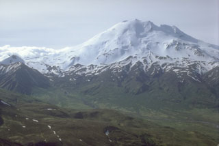
Beginning 22 October, the Alaska Volcano Observatory (AVO) received several reports of increased steaming, snowmelt, and sulfur smells at Chiginagak volcano. Residents of the area, including the community of Pilot Point (60 km NW), noticed increased steam emissions as early as mid-summer 1997. Possible new thermal anomalies were detected on AVHRR satellite imagery in late October. According to AVO, this change in fumarolic activity may have reflected increased heat flux at the volcano.
On 30 October, observers on an AVO flight reported an enlarged area of fumarolic activity directly above previously known sites, including new fumaroles at approximately 1,920 m. However, there were no signs of recently erupted ash, large-scale melting, or mud flows. Observers at Pilot Point reported vigorous steam emissions over the following weeks. During the first week of December, persistent poor weather conditions obscured observations; however, steam was observed on 2 and 3 December. No thermal anomalies were observed on satellite images during the first week of December.
Chiginagak is not monitored by scientific instrumentation; however, satellite imagery and observers in Pilot Point provide information. In addition, Chiginagak is located in a National Wildlife Refuge; the U.S. Fish and Wildlife Service frequently overflies the area, especially when activity persists or intensifies.
Geological Summary. The symmetrical, calc-alkaline Chiginagak stratovolcano located about 15 km NW of Chiginagak Bay contains a small summit crater, which is breached to the south, and one or more summit lava domes. Satellitic lava domes occur high on the NW and SE flanks of the glacier-mantled volcano. An unglaciated lava flow and an overlying pyroclastic-flow deposit extending east from the summit are the most recent products of Chiginagak. They most likely originated from a lava dome at 1687 m on the SE flank, 1 km from the summit of the volcano, which has variably been estimated to be from 2075 to 2221 m high. Brief ash eruptions were reported in July 1971 and August 1998. Fumarolic activity occurs at 1600 m elevation on the NE flank of the volcano, and two areas of hot-spring travertine deposition are located at the NW base of the volcano near Volcano Creek.
Information Contacts: Alaska Volcano Observatory (AVO), a cooperative program of a) U.S. Geological Survey, 4200 University Drive, Anchorage, AK 99508-4667, USA (URL: http://www.avo.alaska.edu/), b) Geophysical Institute, University of Alaska, PO Box 757320, Fairbanks, AK 99775-7320, USA, and c) Alaska Division of Geological & Geophysical Surveys, 794 University Ave., Suite 200, Fairbanks, AK 99709, USA.