Report on Soufriere Hills (United Kingdom) — November 1997

Bulletin of the Global Volcanism Network, vol. 22, no. 11 (November 1997)
Managing Editor: Richard Wunderman.
Soufriere Hills (United Kingdom) Explosions and dome growth
Please cite this report as:
Global Volcanism Program, 1997. Report on Soufriere Hills (United Kingdom) (Wunderman, R., ed.). Bulletin of the Global Volcanism Network, 22:11. Smithsonian Institution. https://doi.org/10.5479/si.GVP.BGVN199711-360050
Soufriere Hills
United Kingdom
16.72°N, 62.18°W; summit elev. 915 m
All times are local (unless otherwise noted)
The following summarizes Scientific Reports of the Montserrat Volcano Observatory (MVO) during 12 October-23 November 1997.
General. During September, activity was dominated by collapses with simultaneous pyroclastic flows down ghauts (BGVN 22:10). Particular events differed in magnitude, column height, or pyroclastic runout, possibly due to time elapsed between events. During 12-21 October, 29 explosions were recorded for a total of 61 since the latest episode began on 28 September. After the last explosion on 21 October, a new dome was seen in the crater, extruding at a rate of up to 8 m3/s. The new dome grew during the following week on the S side, weakening the crater wall on the Galway's side (figure 33) and creating two large vertical cracks on the outside of the wall by 2 November. Further growth in the weakened area led to a 4 November collapse, which removed much of the pre-explosion dome complex material. A subsequent collapse on the 6th removed a significant portion of the new dome and old material. Pyroclastic flows from these collapses reached the sea and a fan deposit at the mouth of White River was significantly extended. Dome growth coincided with large swarms of hybrid earthquakes. After the 6 November collapse, the swarms subsided yet seismicity remained relatively high. Low levels of eruptive activity prevailed for the rest of November. Although bad weather limited observation of the dome, the lobe in the Galway's area was seen as the focus of growth during 9-23 November but at a slower rate. Seismicity included rockfall signals and small-amplitude hybrid earthquakes.
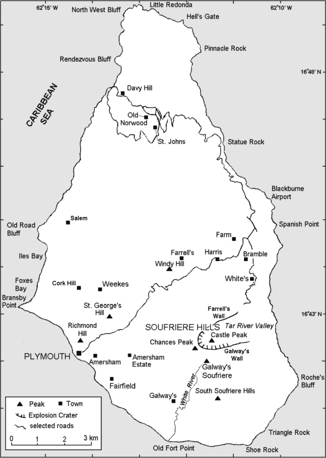 |
Figure 33. Map of Montserrat showing selected towns and features around the Soufriere Hills volcano. |
Visual observations. Vulcanian explosions up to 21 October resulted in pyroclastic flows into surrounding ghauts. Intervals between explosions averaged 8.5 hours with a range of 2.75 to 20.5 hours. During 14-16 October, 12 explosions occurred; intervals between single events lengthened towards the end of the period. Three vigorous explosions on 20-21 October sent plumes to 9,100 m, pumice to Salem and Olveston, and ash to the N. Pumice from Cork's Hill measured up to 10 cm in diameter and ballistics fell 2 km N from the vent. Pyroclastic flows were generally radial for larger explosions; however, the N ghauts were preferred routes because the crater is open to the N. Some flows had relatively small runouts (<1 km) in only one or two ghauts. Pyroclastic flows over the past month have left thin (0.3-1 m) deposits on all flanks, accumulating and infilling the topography. Fort Ghaut in Plymouth and Mosquito Ghaut were completely filled, and Tuitt's and White's Ghauts were partially filled, resulting in fans advancing into towns. Gage's Soufriere was significantly filled with material stacked in front of St. George's hill.
A new dome was first recorded as an incandescence inside the scar during the evening of 22 October. The next day, fresh lava overspilled the tephra rampart between the scar and crater and, by 25 October, occupied a substantial portion of the scar. The lava appeared to be blocky, coarse material, which, due to oxidation at the top of the conduit, is darker than normal (similar to last October; BGVN 21:10). By 25 October the dome's peak had risen to 910 m, 40 m below the crater rim. Growth to the N and vertical infilling of the scar caused rockfalls that traveled a few hundred meters down Tuitt's Ghaut; however, rockfalls were few in number considering the rate and blockiness of the extrusion as well as the steepness of the ghaut. Dome growth continued over the next few weeks with vigorous ash-and-steam venting. Rockfalls from the new dome and old crater coincided with hybrid earthquake swarms.
An overflight on 2 November revealed two large vertical cracks on the Galway's side of the crater; by the next day, these had evolved to deep gullies. Rockfalls on the dome's S side occurred on the morning of 4 November. At 1206 on 4 November, a wide section of the crater in the Galway's area collapsed and caused an hour of pyroclastic flows. Some of the flows reached the sea at O'Garra's and formed a delta. Ash clouds rose to 3000 m. The collapse removed a large part of the old dome but left the 22 October dome mostly intact. Observations on 6 November included two distinct lobes of the new dome separated by a small crater venting ash; the N lobe remained at its 2 November height of 937 m while the S lobe grew. Following 18 hours of high- amplitude tremor a second collapse in the Galway's area began at 1430 on 6 November and lasted 35 minutes. More material was removed than in the previous collapse, rockfalls occurred in Tar River valley and Gage's areas, and an ash plume reaching 4,500 m drifted W.
After a few days of poor visibility, growth of the new dome in the collapse area was revealed. A fin-shaped lobe had grown almost vertically in the old crater wall position; it had a coarse, blocky outer face but a smooth appearance on the inner surface where it extruded out of a cleft in the dome center that exhibited vigorous degassing and venting of ash. The distinct N and S lobes divided by a central cleft or vent were similar to earlier structures (BGVN 21:08 and 22:05), although in this case the N lobe extruded first to reach a certain size then relaxed while growth shifted to the S lobe; this in turn lead to a catastrophic collapse of the old crater wall. Overflight observation on 11 November showed that the S lobe had doubled in size in 3 days to fill the collapse scar of 4-6 November; however, it was extruding at a slower rate. Ash and steam continued to vent from the central cleft. Ash clouds rose to 1800 m drifting W and fell out over Plymouth. Rockfall spalling off the S lobe eroded chutes S of the dome and accumulated in thick deposits in Galway's Soufriere.
Seismicity. Figures 34, 35, and 36 show seismicity during 12 October-23 November. The sequence that began on 22 September (BGVN 22:10) continued until 21 October. Seventy-six explosions at intervals of 3-34 hours were recorded. The explosions appeared as 1-Hz signals of varying relative amplitude and were followed by pyroclastic-flow signals; long-period energy continued through the flow duration and persisted as lower-amplitude tremor of 0.5 to 3 hours duration. Signals coincided with ash venting but there was little or no precursor activity.
 |
Figure 34. Daily events at Soufriere Hills triggering the broadband network system, 12 October-23 November 1997. Event counts are from 1600 on the previous day to 1600 on the date indicated. Data courtesy of MVO. |
 |
Figure 35. Seismic swarms at Soufriere Hills during 20 October-13 November 1997. Data courtesy of MVO. |
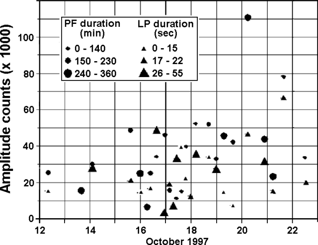 |
Figure 36. Explosions from Soufriere Hills measured at the Windy Hill broadband station during 12-23 October 1997. Amplitudes are peak-to-peak in counts. Data courtesy of MVO. |
The second explosion of 20 October and the first of 21 October were accompanied by swarms of hybrid and volcano-tectonic earthquakes. The second explosion of 21 October initiated 24 hours of hybrid and volcano- tectonic earthquakes and rockfalls down Tuitt's ghaut before ending in a long, sparse swarm on 23 October, although a high level of long-period earthquakes lingered thereafter. Volcano-tectonic earthquakes typically occurred 2-4 km from the top of the dome.
During late October and early November, intense swarms sometimes merged with tremor having frequencies similar to individual hybrids. Hybrid swarms during 1-2 November produced the highest amplitudes since 24 June, reported from stations in Antigua, Dominica, and Nevis. Large pyroclastic-flow signals were recorded on 4 and 6 November. During 6-8 November, particularly high levels of tremor occurred. Individual hybrids were detected on paper but not on the networks due to high background noise; thus low numbers of events did not reflect low activity. Tremor and hybrids were associated with ash venting at the dome. Small pyroclastic flows were recorded on 9 November, but otherwise hybrid earthquakes did not generate external activity. Amplitudes became progressively smaller later in November; from 14 November to the end of the month, rockfall signals dominated, although a significant number of low-amplitude hybrids not grouped in swarms occurred but were not detected by the network.
Ground deformation. On 20 October, a GPS survey was taken; however, the only sites accessible were White's, Harris, and Windy Hill due to thick ash cover. Measurement from Harris to White's showed a 2-cm increase since 20 September, closer to the pre-June 1997 level. Although less than two standard deviations below the mean, this single measurement did not indicate an acceleration in deformation. The line from Harris to Windy Hill showed slight shortening since 12 August. EDM measurements to Lee's Yard from MVO on 14 October revealed an increase of 1 cm since July.
Volume measurements. Gross morphology of the pre-21 September dome was unchanged since the collapse on that day (BGVN 22:10) until 22 October with some exceptions (see Visual observations). The volume of the 22 October dome was measured by geometric calculation until a survey was taken. Assuming the dome completely filled the explosion crater by 23 October (when overspilling was observed), the volume was approximately 1.7 x 10⁶ m3 resulting in an extrusion rate of 8-10 m3/s, depending on the time of first appearance. A detailed survey was made on 6 November, before the collapse, from several points; theodolite points from Jackboy Hill, Center Hills, and Flemings, a GPS point at Center Hills (to be used in future surveys as an additional static photo point), and helicopter survey photographs of most areas around the dome except the Galway's side. Good coverage of the N lobe of the 22 October dome was obtained. Since this area had not changed since 3 November, the volume was calculated at 5 x 10⁶ m3. Collapse volumes were calculated separately for an average extrusion rate of 5 m3/s over the first 11 days of the "22 October" dome growth. Visual observation revealed that the 4 November collapse involved less material than the 6 November collapse. The latest estimates of collapse volumes were 1.8 x 10⁶ m3 from 4 November and 3.4 x 10⁶ m3 from 6 November. The bulk of the collapse material was deposited in fans at the end of valleys that will be surveyed when the ash subsides. A 17 November survey of the White River valley fan revealed total deposits of 13.6 x 10⁶ m3, an increase of 5.5 x 10⁶ m3 since 15 May, resulting mostly from the 4 and 6 November collapses. The survey did not include recent deposits in the upper valley still covered in ash.
Environmental monitoring. Dust Trak sampling to measure airborne particulates was carried out at four fixed sites. The values at the fixed sites were low (3) during 12 October-23 November, except for the Catholic school site, which sometimes recorded elevated levels (0.05-0.1 mg/m3). This effect is caused by the large amount of human activity at this site and its location near a main road. Towards the end of this reporting period the three sites (not including the school) all had remarkably similar average concentrations each day. A new Dust Trak site was established at Mango Drive in Woodlands on 16 November to replace the Runaway site.
Geological Summary. The complex, dominantly andesitic Soufrière Hills volcano occupies the southern half of the island of Montserrat. The summit area consists primarily of a series of lava domes emplaced along an ESE-trending zone. The volcano is flanked by Pleistocene complexes to the north and south. English's Crater, a 1-km-wide crater breached widely to the east by edifice collapse, was formed about 2000 years ago as a result of the youngest of several collapse events producing submarine debris-avalanche deposits. Block-and-ash flow and surge deposits associated with dome growth predominate in flank deposits, including those from an eruption that likely preceded the 1632 CE settlement of the island, allowing cultivation on recently devegetated land to near the summit. Non-eruptive seismic swarms occurred at 30-year intervals in the 20th century, but no historical eruptions were recorded until 1995. Long-term small-to-moderate ash eruptions beginning in that year were later accompanied by lava-dome growth and pyroclastic flows that forced evacuation of the southern half of the island and ultimately destroyed the capital city of Plymouth, causing major social and economic disruption.
Information Contacts: Montserrat Volcano Observatory (MVO), c/o Chief Minister's Office, PO Box 292, Plymouth, Montserrat (URL: http://www.mvo.ms/).