Report on Villarrica (Chile) — March 1998
Bulletin of the Global Volcanism Network, vol. 23, no. 3 (March 1998)
Managing Editor: Richard Wunderman.
Villarrica (Chile) Escalating seismic amplitudes in March prelude to more explosions and ash
Please cite this report as:
Global Volcanism Program, 1998. Report on Villarrica (Chile) (Wunderman, R., ed.). Bulletin of the Global Volcanism Network, 23:3. Smithsonian Institution. https://doi.org/10.5479/si.GVP.BGVN199803-357120
Villarrica
Chile
39.42°S, 71.93°W; summit elev. 2847 m
All times are local (unless otherwise noted)
Luis Hernan Ecueñique, a manager in charge of "Las Cavernas," a tourist attraction 8 km from Villarrica's active crater, noted that during late March through at least early April there had been an ascent of magma in the central crater. Erupted material reached ~100 m from the crater's edge. Local tour guides had also informed him that explosions had deposited tephra on the N flanks. Measurements within "Las Cavernas" (which are lava tubes) indicated the air temperature rose by about 2°C.
A digital seismic station 21 km from the crater failed to detect either an increase in the number of seismic events or a shift in their character; the system did register a minor increase in event amplitude.
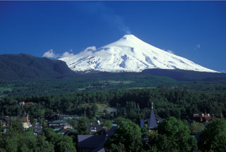
Geological Summary. The glacier-covered Villarrica stratovolcano, in the northern Lakes District of central Chile, is ~15 km south of the city of Pucon. A 2-km-wide caldera that formed about 3,500 years ago is located at the base of the presently active, dominantly basaltic to basaltic andesite cone at the NW margin of a 6-km-wide Pleistocene caldera. More than 30 scoria cones and fissure vents are present on the flanks. Plinian eruptions and pyroclastic flows that have extended up to 20 km from the volcano were produced during the Holocene. Lava flows up to 18 km long have issued from summit and flank vents. Eruptions documented since 1558 CE have consisted largely of mild-to-moderate explosive activity with occasional lava effusion. Glaciers cover 40 km2 of the volcano, and lahars have damaged towns on its flanks.
Information Contacts: Gustavo Fuentealba1 and Paola Peña S., Observatorio Volcanológico de Los Andes del Sur (OVDAS), Manantial 1710-Carmino del Alba, Temuco, Chile; 1Universidad de La Frontera (UFRO), Departamento Ciencias Fisicas, Universidad de la Frontera, Avda. Francisco Salazar 01145, Casilla 54-D, Temuco, Chile.

