Report on Whakaari/White Island (New Zealand) — April 1998

Bulletin of the Global Volcanism Network, vol. 23, no. 4 (April 1998)
Managing Editor: Richard Wunderman.
Whakaari/White Island (New Zealand) Hydrothermal eruptions in late March
Please cite this report as:
Global Volcanism Program, 1998. Report on Whakaari/White Island (New Zealand) (Wunderman, R., ed.). Bulletin of the Global Volcanism Network, 23:4. Smithsonian Institution. https://doi.org/10.5479/si.GVP.BGVN199804-241040
Whakaari/White Island
New Zealand
37.52°S, 177.18°E; summit elev. 294 m
All times are local (unless otherwise noted)
Minor hydrothermal eruptions occurred at White Island over the period 28-29 March. Lake floor mud, blocks, and tephra were ejected across the main crater floor and over the N flank of the 1978/1990 crater complex. Tephra was thickest around Noisy Nellie crater, and numerous impact craters were also observed. Small scale steam eruptions were continuing from a vent in the Crater Complex.
Deformation. A leveling survey on 8 April showed a decline in the subsidence rate; minor uplift was apparent across much of the crater floor. Figure 30 shows differences in height between 8 December 1997 and 8 April 1998. Figure 31 shows a time series of selected pegs. Some subsidence is continuing, particularly in the Donald Mound area.
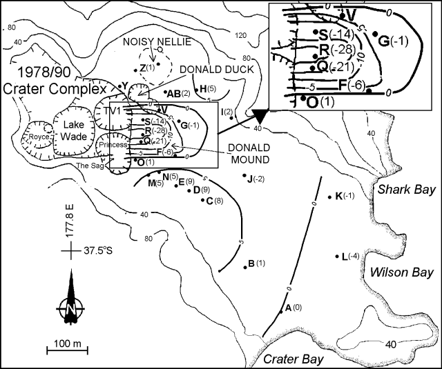 |
Figure 30. Contour map of White Island showing height changes in millimeters between 8 December 1997 and 8 April 1998. Contours are in meters above sea level. Courtesy IGNS. |
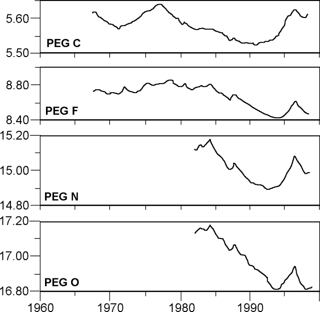 |
Figure 31. Time series showing height changes at selected pegs. Heights are meters above origin. Courtesy IGNS. |
Seismicity. The recent hydrothermal activity was accompanied by an increase in the level of volcanic tremor. Figure 32 shows the daily average tremor for 1998. The dominant frequency did not change significantly.
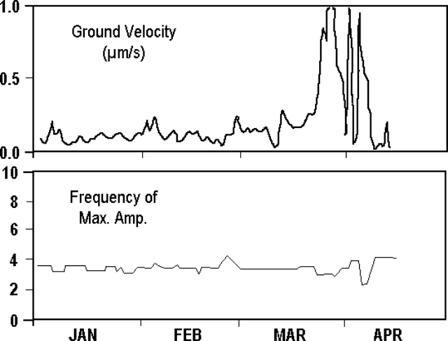 |
Figure 32. Time series showing ground velocity (upper) and dominant frequency (lower) of volcanic tremor at White Island. Courtesy IGNS. |
Gas and fumarole chemistry. Gas and water samples collected during recent visits initially showed a decrease in water content. Fumarole temperatures showed little change. During a COSPEC flight on 20 March only 140 tons per day of SO2 were recorded; a flight 3 April indicated an increase to over 400 tons per day, consistent with the fumaroles drying out and allowing more gas to escape.
Magnetics. Three notable trends can be seen between 6 May 1997 and 8 April 1998 (figure 33). Magnetic increases N of Donald Mound correspond to decreases to the S: for example, an increase of 140 nT at site 'S' corresponds to a decrease of 43 nT at site 'P'. These may indicate shallow ( ± 50 m depth) cooling under Donald Mound. The decreases further N around Donald Duck and Noisy Nellie (e.g. -45 nT at site 'Y') could indicate deeper heating that is being masked by the shallow cooling. Both trends are continuations of those seen early in 1997 (BGVN 22:02). A third trend could be indicated by the decrease at 'CT5' (24 nT) and corresponding increase at 'CT3' (20 nT). These suggest localized, very shallow ( ± 20 m) heating in the vicinity of fumaroles SE of Donald Mound. Sites to the extreme N and S of the crater were not surveyed. Overall, the magnetic changes remain smaller than in 1995-96.
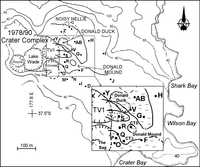 |
Figure 33. Contour map showing magnetic changes (in nT) between 6 May 1997 and 8 April 1998. Courtesy IGNS. |
Summary. Monitoring data suggest the deflationary-cooling trends of the last 2-3 years are starting to reverse. This could lead to further eruptions. Should magmatic activity occur it would be stronger than the present hydrothermal activity and likely pose a risk to visitors on shore.
Geological Summary. The uninhabited Whakaari/White Island is the 2 x 2.4 km emergent summit of a 16 x 18 km submarine volcano in the Bay of Plenty about 50 km offshore of North Island. The island consists of two overlapping andesitic-to-dacitic stratovolcanoes. The SE side of the crater is open at sea level, with the recent activity centered about 1 km from the shore close to the rear crater wall. Volckner Rocks, sea stacks that are remnants of a lava dome, lie 5 km NW. Descriptions of volcanism since 1826 have included intermittent moderate phreatic, phreatomagmatic, and Strombolian eruptions; activity there also forms a prominent part of Maori legends. The formation of many new vents during the 19th and 20th centuries caused rapid changes in crater floor topography. Collapse of the crater wall in 1914 produced a debris avalanche that buried buildings and workers at a sulfur-mining project. Explosive activity in December 2019 took place while tourists were present, resulting in many fatalities. The official government name Whakaari/White Island is a combination of the full Maori name of Te Puia o Whakaari ("The Dramatic Volcano") and White Island (referencing the constant steam plume) given by Captain James Cook in 1769.
Information Contacts: B.J. Scott, Institute of Geological and Nuclear Sciences (IGNS), Private Bag 2000, Wairakei, New Zealand.