Report on Atka Volcanic Complex (United States) — June 1998
Bulletin of the Global Volcanism Network, vol. 23, no. 6 (June 1998)
Managing Editor: Richard Wunderman.
Atka Volcanic Complex (United States) Low eruption plume seen in June, dusting of ash in Atka
Please cite this report as:
Global Volcanism Program, 1998. Report on Atka Volcanic Complex (United States) (Wunderman, R., ed.). Bulletin of the Global Volcanism Network, 23:6. Smithsonian Institution. https://doi.org/10.5479/si.GVP.BGVN199806-311160
Atka Volcanic Complex
United States
52.331°N, 174.139°W; summit elev. 1518 m
All times are local (unless otherwise noted)
At about 1000 on 30 June, the Alaska Volcano Observatory (AVO) received a report of an eruption at Korovin from an observer in the village of Atka, near the volcano. The crew of a Coast Guard C-130 airplane confirmed that a low-level eruption plume had risen to almost 5 km above sea level by 1030, and late in the afternoon a pilot reported the plume at 9 km. The low-level ash-and-steam plume was not visible on satellite imagery due to meteorological clouds. Local winds at the time were light and to the SSW. A dusting of ash was reported in Atka. Poor weather on 1 July prohibited both direct and satellite observations.
Korovin volcano is located on the north end of Atka Island in the central Aleutians (figure 1), 538 km W of Dutch Harbor. It is 21 km N of the village of Atka, which has a population of about 100. The last reported eruption was in March 1987. AVO does not maintain seismic monitoring equipment on Atka Island.
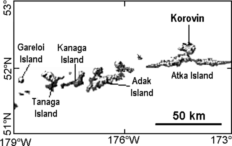 |
Figure 1. Location of Korovin [Atka] volcano in the Aleutians. Map courtesy of AVO. |
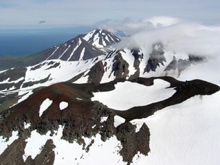
Geological Summary. The Atka Volcanic Complex consists of a central shield and Pleistocene caldera and four notable volcanic cones. A major explosive dacitic eruption accompanied formation of the caldera about 500,000 to 300,000 years ago; approximately half of the caldera rime remains, open towards the NW. The Sarichef cone, ~5 km ESE of the caldera rim, retains a symmetrical profile, unlike most other heavily eroded features outside the caldera to the S and W. The Kliuchef stratovolcano grew within the caldera and exhibits five eruptive vents striking NE, including two at the summit, that have been active in the Holocene. A 700-m-diameter crater 1 km NE of the summit may have been the source vent for a large 1812 CE eruption. Hot springs and fumaroles are located on the flanks of Kliuchef and in a glacial valley to the SW. The most frequently active volcano of the complex is Korovin, at the NE tip of Atka Island about 5 km N of Kliuchef. An 800-m-diameter crater on the SE side of the summit contains a deep circular pit that sometimes contains a crater lake thought to be the source of phreatic ash explosions. The smaller Konia cone, slightly offset to the E, lies between Kliuchef and Korovin. Most of the lava flows in the complex are basaltic, though some dacitic flows are also present.
Information Contacts: Alaska Volcano Observatory (AVO), a cooperative program of a) U.S. Geological Survey, 4200 University Drive, Anchorage, AK 99508-4667, USA (URL: http://www.avo.alaska.edu/), b) Geophysical Institute, University of Alaska, PO Box 757320, Fairbanks, AK 99775-7320, USA, and c) Alaska Division of Geological & Geophysical Surveys, 794 University Ave., Suite 200, Fairbanks, AK 99709, USA.