Report on Merapi (Indonesia) — July 1998

Bulletin of the Global Volcanism Network, vol. 23, no. 7 (July 1998)
Managing Editor: Richard Wunderman.
Merapi (Indonesia) Increasing activity culminates in mid-July pyroclastic flows
Please cite this report as:
Global Volcanism Program, 1998. Report on Merapi (Indonesia) (Wunderman, R., ed.). Bulletin of the Global Volcanism Network, 23:7. Smithsonian Institution. https://doi.org/10.5479/si.GVP.BGVN199807-263250
Merapi
Indonesia
7.54°S, 110.446°E; summit elev. 2910 m
All times are local (unless otherwise noted)
Seismic activity and avalanches increased significantly at Merapi beginning in June, and reached a climax in mid-July. According to Xinhua News Agency reports, pyroclastic flows and ashfall near populated areas caused concern among Volcanological Survey of Indonesia (VSI) scientists and civil authorities; evacuations were considered. VSI ranks alert status as follows, in increasing level of concern: Normal, Waspada, Siap, and Awas.
Increasing eruptive activity during the last week of June prompted officials to increase the alert level to Waspada on 2 July. As activity progressed to more dangerous levels, the alert status increased to Siaga at 0500 on 8 July, eventually reaching Awas at 0438 on 11 July, before returning to Siaga at 1200 on 12 July. A solfatara plume was observed during late June and early July; gases escaped with varying pressure to form a thin (or sometimes thick) white cloud attaining maximum heights of 1,400 m above the summit in the first week of July, and 2,000 m by 11 July. Avalanches extending as long as 1.5 km coursed through the upper portions of the Senowo river, and others were seen in the Lamat, Krasak/Bebeng and Boyong rivers (figure 18). Glowing at the summit resumed in late June. During the reporting interval seismic activity showed a significant increase; specifically, the number of shallow volcanic (B-type), multi-phase (MP), low-frequency (LF), and rockfall events increased sharply (table 9).
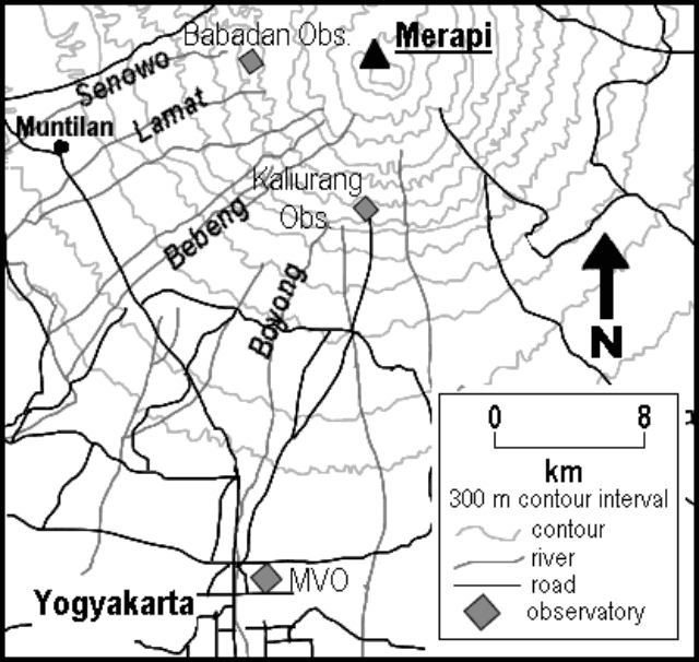 |
Figure 18. Contour map of Merapi's southern segment indicating locations referred to in the text. Courtesy of Merapi Volcano Observatory. |
Table 9. The number of daily seismic events of various types at Merapi as recorded from mid-June to mid-July 1998. Data courtesy of VSI's Merapi Volcano Observatory.
| Dates | B-type | Low-frequency | Multiphase | Rockfalls | Tremor | Tectonic |
| 15 Jun-21 Jun 1998 | 4 | -- | 33 | 5 | -- | 4 |
| 22 Jun-28 Jun 1998 | 3 | -- | 45 | 15 | -- | 3 |
| 29 Jun-06 Jul 1998 | 47 | 3 | 925 | 142 | -- | 5 |
| 07 Jul-12 Jul 1998 | 21 | 1 | 2029 | 613 | -- | 2 |
| 17 Jul-21 Jul 1998 | 19 | 2 | 605 | 860 | 2 | 1 |
The amount of measured deformation also increased (although the summit tiltmeter station was rendered inoperative after 8 July). Explosions on 11 July could be heard as far away as 20 km S in the city of Yogyakarta. VSI noted, "lava was seen ejecting from the crater." In addition, and presumably with undue exaggeration, Xinhua news reporters claimed that some areas near the volcano were under 1.5 m of ash that blanketed crops and plantations.
On 19 July, Babadan Observatory located 4 km W of the summit reported three 'guguran' (pyroclastic flows resulting from dome collapse in the crater). These occurred between midnight and 0600, some reaching as far as 2,500 m down the Lamat River. VSI also noted a "thick white solfataric ash plume"; it stood 50 m in height and was observed from Kaliurang beginning at 0545. Pyroclastic flows during the remaining morning ran 5,000 m down the Lamat River valley, and an eruptive column rose up to 4,500 m above the summit. Between 0600 and 1313, seismic stations recorded 347 multiphase (MP) events. Tremor occurred between 1325 and 1503 and was accompanied by five pyroclastic flows that reached 2,000-5,000 m from the summit. At 1330 VSI ordered workers on the W sector of the volcano to leave the area. At 1501 Merapi erupted violently; several pyroclastic flows traveled 5,500 m down Lamat River and an eruptive column rose up to 6,000 m above the summit by 1507. At about 1615 ash showered the W side of the volcano, accumulating up to 2 mm in Muntilan. Ash also fell in Purworejo (42 km W of Yogyakarta) and Temanggung (35 km NW of the crater). Shallow volcanic earthquakes at 1625 were followed by small tremor. As many as 25 pyroclastic flows continued until 1800, some causing ash showers in nearby villages. There were B-type events (16), MP events ( 399 ), pyroclastic flows (119), and some glowing rockfalls throughout the afternoon.
Activity had subsided by 21 June, although fog obscured the summit area. Thick white ash rose to 460 m. Glowing rockfalls sometimes ran 1,250 m down the Lamat River valley.
This hazardous stratovolcano is located 70 km SE of Dieng and immediately N of Yogyakarta, a city of half a million people. In 32 of its 67 historical eruptions, nuées ardentes took place-more than known at any other volcano in the world-and 11 of them have caused fatalities. The volcano is carefully watched by several VSI observatories and heavily monitored instrumentally.
Geological Summary. Merapi, one of Indonesia's most active volcanoes, lies in one of the world's most densely populated areas and dominates the landscape immediately north of the major city of Yogyakarta. It is the youngest and southernmost of a volcanic chain extending NNW to Ungaran volcano. Growth of Old Merapi during the Pleistocene ended with major edifice collapse perhaps about 2,000 years ago, leaving a large arcuate scarp cutting the eroded older Batulawang volcano. Subsequent growth of the steep-sided Young Merapi edifice, its upper part unvegetated due to frequent activity, began SW of the earlier collapse scarp. Pyroclastic flows and lahars accompanying growth and collapse of the steep-sided active summit lava dome have devastated cultivated lands on the western-to-southern flanks and caused many fatalities.
Information Contacts: Mas Atje Purbawinata, Director, Merapi Volcano Observatory, Volcanological Survey of Indonesia, Jalan Cendana 15 Yogyakarta 55166 (URL: http://www.vsi.esdm.go.id/); Xinhua News Agency, 5 Sharp Street West, Wanchai, Hong Kong.