Report on Hokkaido-Komagatake (Japan) — September 1998
Bulletin of the Global Volcanism Network, vol. 23, no. 9 (September 1998)
Managing Editor: Richard Wunderman.
Hokkaido-Komagatake (Japan) Phreatic eruption spreads ash 25 October
Please cite this report as:
Global Volcanism Program, 1998. Report on Hokkaido-Komagatake (Japan) (Wunderman, R., ed.). Bulletin of the Global Volcanism Network, 23:9. Smithsonian Institution. https://doi.org/10.5479/si.GVP.BGVN199809-285020
Hokkaido-Komagatake
Japan
42.063°N, 140.677°E; summit elev. 1131 m
All times are local (unless otherwise noted)
The Japan Meteorological Agency (JMA) issued an advisory and three observation reports concerning Hokkaido-Komaga-take volcano on 25 October following a small-scale phreatic eruption that began at 0912 the same day. Ash rose in a column to a height of ~1,200 m above the crater. The eruptive activity soon declined. There were no report of injuries or damage caused by the eruption, and no evacuation order was issued.
Volcanologists surveyed the activity from a helicopter the afternoon of 25 October (figure 2). They reported that the eruption originated from the same crater that opened during the 1929 eruption, which was also the site of the March 1996 eruption. Ash covered a significant area around and to the E of the crater. The scale of this eruption apparently was smaller than that of the March 1996 eruption.
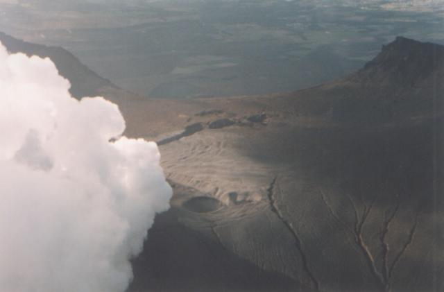 |
Figure 2. An aerial view of Komaga-take showing fuming activity from the 1929 Crater about 6 hours after the 25 October 1998 eruption. View is from the SE looking towards the Komanose Rim (back) and the Sawaradake Rim (back right). The 1942 Large Fissure (middle, diagonal) and the 1996 Southern Fissure Crater (middle center) can also be seen. Hyoutan Crater (front center) is adjacent to the 1929 Crater. Photograph by Bousai Heli; courtesy of Hiromu Okada, Usu Volcano Observatory. |
Volcanic tremor lasting six minutes was associated with this eruption. In addition, five volcanic earthquakes were recorded in the 12 hours following the first eruption signs.
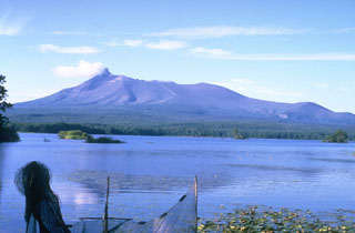
Komaga-take is located 30 km N of Hakodate City (population 320,000). The andesitic stratovolcano has a 2-km-wide horseshoe-shaped caldera open to the E. The volcano has generated large pyroclastic eruptions, including major historical eruptions in 1640, 1856, and 1929. In the 1640 eruption, debris from a partial summit collapse entered the sea resulting in a tsunami that killed 700 people. Although the 1929 eruption was one of the largest 20th-century eruptions in Japan, it may not have had clear geophysical precursors.
Geological Summary. Much of the truncated Hokkaido-Komagatake andesitic volcano on the Oshima Peninsula of southern Hokkaido is Pleistocene in age. The sharp-topped summit lies at the western side of a large breached crater that formed as a result of edifice collapse in 1640 CE. Hummocky debris avalanche material occurs at the base of the volcano on three sides. Two late-Pleistocene and two Holocene Plinian eruptions occurred prior to the first historical eruption in 1640, which began a period of more frequent explosive activity. The 1640 eruption, one of the largest in Japan during historical time, deposited ash as far away as central Honshu and produced a debris avalanche that reached the sea. The resulting tsunami caused 700 fatalities. Three Plinian eruptions have occurred since 1640; in 1694, 1856, and 1929.
Information Contacts: J. Miyamura, Sapporo District, Japan Meteorological Agency, 1-3-4 Ote-machi, Chiyoda-ku, Tokyo 100, Japan; Hiromu Okada, Usu Volcano Observatory, Institute of Seismology and Volcanology, Hokkaido University, Sohbetsu-cho, Hokkaido 052-0103, Japan.